
| Memorials | : | 0 |
| Location | : | Lodsworth, Chichester District, England |
| Coordinate | : | 50.9968230, -0.6746850 |
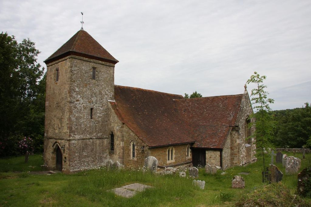
| Description | : | The church of ST. PETER stands south-east of the village. It is built of local sandstone ashlar and roofed with tile; the tower is plastered. To a nave and chancel of earlier, but uncertain, date a tower was added in about the 14th century; in the 19th a transept and aisle were added on each side of the nave, and the chancel was rebuilt and a vestry added to the north of it. The spring near St Peters church was a place of pilgrimage in the Middle Ages, especially for people with eye problems, and a source of revenue for the... Read More |
frequently asked questions (FAQ):
-
Where is St Peter Churchyard?
St Peter Churchyard is located at Lodsworth, Chichester District ,West Sussex ,England.
-
St Peter Churchyard cemetery's updated grave count on graveviews.com?
0 memorials
-
Where are the coordinates of the St Peter Churchyard?
Latitude: 50.9968230
Longitude: -0.6746850


Nearby Cemetories:
1. Pitshill Garden of Rest
Tillington, Chichester District, England
Coordinate: 50.9893710, -0.6320950
2. All Hallows Churchyard Extension
Tillington, Chichester District, England
Coordinate: 50.9893231, -0.6313783
3. All Hallows Churchyard
Tillington, Chichester District, England
Coordinate: 50.9893180, -0.6291640
4. Easebourne Priory
Easebourne, Chichester District, England
Coordinate: 50.9950335, -0.7258487
5. St Mary Magdelene Churchyard
West Lavington, Chichester District, England
Coordinate: 50.9773640, -0.7311840
6. Hampers Green Cemetery
Petworth, Chichester District, England
Coordinate: 50.9963280, -0.6101350
7. St Laurence Churchyard
Lurgashall, Chichester District, England
Coordinate: 51.0372620, -0.6634070
8. St Mary the Virgin Churchyard
Petworth, Chichester District, England
Coordinate: 50.9879345, -0.6096756
9. Horsham Road Cemetery
Petworth, Chichester District, England
Coordinate: 50.9920830, -0.6066060
10. Bartons Lane Cemetery
Petworth, Chichester District, England
Coordinate: 50.9870920, -0.6073540
11. Carron Lane Cemetery
Midhurst, Chichester District, England
Coordinate: 50.9857040, -0.7513620
12. St James Churchyard
Heyshott, Chichester District, England
Coordinate: 50.9556210, -0.7238880
13. Holy Trinity Churchyard
Duncton, Chichester District, England
Coordinate: 50.9491400, -0.6337740
14. St Richard's Church
Duncton, Chichester District, England
Coordinate: 50.9486600, -0.6230000
15. Fernhurst Burial Ground
Fernhurst, Chichester District, England
Coordinate: 51.0486080, -0.7220610
16. St Peters Churchyard
East Lavington, Chichester District, England
Coordinate: 50.9379250, -0.6550920
17. St. James Churchyard
Stedham, Chichester District, England
Coordinate: 50.9962590, -0.7703560
18. Ebernoe Holy Trinity Churchyard
Ebernoe, Chichester District, England
Coordinate: 51.0415420, -0.6099770
19. St Michael Churchyard
Northchapel, Chichester District, England
Coordinate: 51.0561371, -0.6426890
20. St Bartholomew Churchyard
Egdean, Chichester District, England
Coordinate: 50.9716740, -0.5819790
21. St. Mary's Churchyard
Iping, Chichester District, England
Coordinate: 51.0000351, -0.7865786
22. St. Luke's Churchyard
Linch, Chichester District, England
Coordinate: 51.0404840, -0.7720810
23. St Mary the Virgin Churchyard
Fittleworth, Chichester District, England
Coordinate: 50.9641190, -0.5641100
24. St. John The Baptist Churchyard Cemetery
Sutton, Chichester District, England
Coordinate: 50.9316638, -0.6080123