
| Memorials | : | 0 |
| Location | : | New Hutton, South Lakeland District, England |
| Website | : | www.achurchnearyou.com/church/12371/ |
| Coordinate | : | 54.3156560, -2.6747130 |
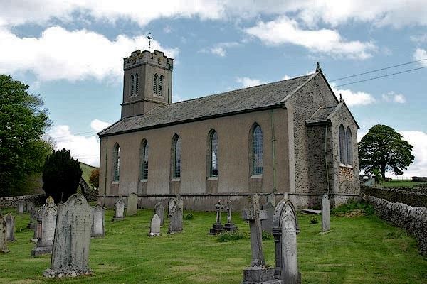
| Description | : | Church of St. Stephen, New Hutton, South Lakeland, Cumbria. Parish Church. 1828-29 by George Webster. Pebble-dashed rubble on battered plinth; hammer-dressed stone details. Graduated slate roofs with stone copings and kneelers. 3-stage western tower partly incorporated into 5-bay nave; single-bay chancel. String above plinth. Panelled double door in splayed surround with pointed head; window set back on either side, window and louvred belfry opening above. Tower has stepped crenellation to parapet. 5 windows to nave, paired east window to chancel. All windows in splayed surrounds with pointed heads; all, except east windows, square-leaded panes. Moulded cast iron guttering. Interior: Original numbered... Read More |
frequently asked questions (FAQ):
-
Where is St. Stephen's Churchyard?
St. Stephen's Churchyard is located at New Hutton, South Lakeland District ,Cumbria , LA8 0ASEngland.
-
St. Stephen's Churchyard cemetery's updated grave count on graveviews.com?
0 memorials
-
Where are the coordinates of the St. Stephen's Churchyard?
Latitude: 54.3156560
Longitude: -2.6747130
Nearby Cemetories:
1. Quaker Burial Ground
Kendal, South Lakeland District, England
Coordinate: 54.3278200, -2.7285500
2. Parkside Cemetery
Kendal, South Lakeland District, England
Coordinate: 54.3210870, -2.7362680
3. Castle Street Cemetery
Kendal, South Lakeland District, England
Coordinate: 54.3301600, -2.7365160
4. St Mark's Churchyard
Natland, South Lakeland District, England
Coordinate: 54.2961380, -2.7374200
5. Holy Trinity Church
Kendal, South Lakeland District, England
Coordinate: 54.3223970, -2.7448770
6. Kendal Quaker Meeting House
Kendal, South Lakeland District, England
Coordinate: 54.3287200, -2.7431900
7. Kendal Unitarian Chapel Burial Ground
Kendal, South Lakeland District, England
Coordinate: 54.3287120, -2.7450940
8. The Sepulchre Quaker Burial Ground
Kendal, South Lakeland District, England
Coordinate: 54.3270022, -2.7502978
9. St. Thomas Churchyard
Kendal, South Lakeland District, England
Coordinate: 54.3316130, -2.7489140
10. Stricklandgate Methodist
Kendal, South Lakeland District, England
Coordinate: 54.3321160, -2.7493720
11. St. John The Baptist Cemetery Extension
Skelsmergh, South Lakeland District, England
Coordinate: 54.3519250, -2.7249650
12. St. John the Baptist Cemetery
Skelsmergh, South Lakeland District, England
Coordinate: 54.3521700, -2.7253800
13. St. Thomas' Churchyard
Crosscrake, South Lakeland District, England
Coordinate: 54.2763700, -2.7335300
14. Quaker Burial Ground - Grayrigg
Grayrigg, South Lakeland District, England
Coordinate: 54.3664563, -2.6483654
15. St John the Evangelist Churchyard
Grayrigg, South Lakeland District, England
Coordinate: 54.3681500, -2.6501200
16. St John the Evangelist Churchyard
Firbank, South Lakeland District, England
Coordinate: 54.3365050, -2.5737670
17. St Oswald Churchyard
Burneside, South Lakeland District, England
Coordinate: 54.3546500, -2.7634950
18. St Gregory Churchyard
Sedbergh, South Lakeland District, England
Coordinate: 54.3240650, -2.5637360
19. Friends Meeting House Burial Ground
Preston Patrick, South Lakeland District, England
Coordinate: 54.2499970, -2.7042040
20. Helsington Churchyard
Helsington, South Lakeland District, England
Coordinate: 54.2934390, -2.7871630
21. Quaker Graveyard
Brigflatts, South Lakeland District, England
Coordinate: 54.3146190, -2.5533360
22. Church of Holy Ghost
Middleton, South Lakeland District, England
Coordinate: 54.2697500, -2.5800700
23. Holy Trinity Churchyard
Sedbergh, South Lakeland District, England
Coordinate: 54.3494590, -2.5651420
24. St. Patrick's Churchyard
Preston Patrick, South Lakeland District, England
Coordinate: 54.2451230, -2.7120480