
| Memorials | : | 0 |
| Location | : | Kendal, South Lakeland District, England |
| Coordinate | : | 54.3270022, -2.7502978 |
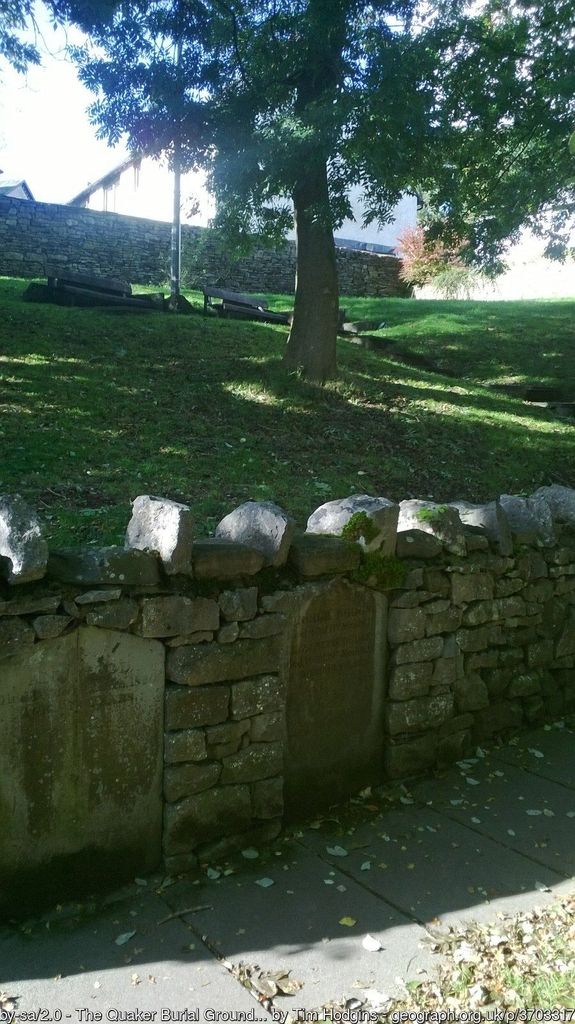
| Description | : | This is a disused burial ground now landscaped into a public garden. It is Kendal's earliest Quaker burial ground. Sometimes known as Fellside Quaker Cemetery. The burial ground on which the small park is now built on, was bought in 1656 by the Kendal Quakers for £9 3s 0d. It was extended to accommodate burials from Underbarrow Quakers chapter when their own burial ground was ploughed up by a 'renegade' member. It was closed to burials in 1855 and in 1863 the graves were levelled and part of the burial ground was made into gardens. There are three headstones remaining, but... Read More |
frequently asked questions (FAQ):
-
Where is The Sepulchre Quaker Burial Ground?
The Sepulchre Quaker Burial Ground is located at Kendal, South Lakeland District ,Cumbria ,England.
-
The Sepulchre Quaker Burial Ground cemetery's updated grave count on graveviews.com?
0 memorials
-
Where are the coordinates of the The Sepulchre Quaker Burial Ground?
Latitude: 54.3270022
Longitude: -2.7502978
Nearby Cemetories:
1. Kendal Unitarian Chapel Burial Ground
Kendal, South Lakeland District, England
Coordinate: 54.3287120, -2.7450940
2. Kendal Quaker Meeting House
Kendal, South Lakeland District, England
Coordinate: 54.3287200, -2.7431900
3. St. Thomas Churchyard
Kendal, South Lakeland District, England
Coordinate: 54.3316130, -2.7489140
4. Stricklandgate Methodist
Kendal, South Lakeland District, England
Coordinate: 54.3321160, -2.7493720
5. Holy Trinity Church
Kendal, South Lakeland District, England
Coordinate: 54.3223970, -2.7448770
6. Castle Street Cemetery
Kendal, South Lakeland District, England
Coordinate: 54.3301600, -2.7365160
7. Parkside Cemetery
Kendal, South Lakeland District, England
Coordinate: 54.3210870, -2.7362680
8. Quaker Burial Ground
Kendal, South Lakeland District, England
Coordinate: 54.3278200, -2.7285500
9. St Oswald Churchyard
Burneside, South Lakeland District, England
Coordinate: 54.3546500, -2.7634950
10. St. John The Baptist Cemetery Extension
Skelsmergh, South Lakeland District, England
Coordinate: 54.3519250, -2.7249650
11. St. John the Baptist Cemetery
Skelsmergh, South Lakeland District, England
Coordinate: 54.3521700, -2.7253800
12. St Mark's Churchyard
Natland, South Lakeland District, England
Coordinate: 54.2961380, -2.7374200
13. Helsington Churchyard
Helsington, South Lakeland District, England
Coordinate: 54.2934390, -2.7871630
14. All Saints Churchyard
Underbarrow, South Lakeland District, England
Coordinate: 54.3262900, -2.8268240
15. St. Stephen's Churchyard
New Hutton, South Lakeland District, England
Coordinate: 54.3156560, -2.6747130
16. St. Thomas' Churchyard
Crosscrake, South Lakeland District, England
Coordinate: 54.2763700, -2.7335300
17. Crook Chapel of Saint Catherine
Crook, South Lakeland District, England
Coordinate: 54.3445250, -2.8477290
18. St. Catherine's Churchyard
Crook, South Lakeland District, England
Coordinate: 54.3480260, -2.8462220
19. St. Mary's Churchyard
Crosthwaite, South Lakeland District, England
Coordinate: 54.3129300, -2.8526100
20. St. Thomas' Churchyard
Selside, South Lakeland District, England
Coordinate: 54.3861600, -2.7169400
21. Crosthwaite Cemetery
Crosthwaite, South Lakeland District, England
Coordinate: 54.3126000, -2.8546900
22. St James Churchyard
Staveley, South Lakeland District, England
Coordinate: 54.3801350, -2.8183670
23. St John the Evangelist Churchyard
Levens, South Lakeland District, England
Coordinate: 54.2647380, -2.7920660
24. Quaker Burial Ground - Grayrigg
Grayrigg, South Lakeland District, England
Coordinate: 54.3664563, -2.6483654