
| Memorials | : | 0 |
| Location | : | Kendal, South Lakeland District, England |
| Coordinate | : | 54.3287200, -2.7431900 |
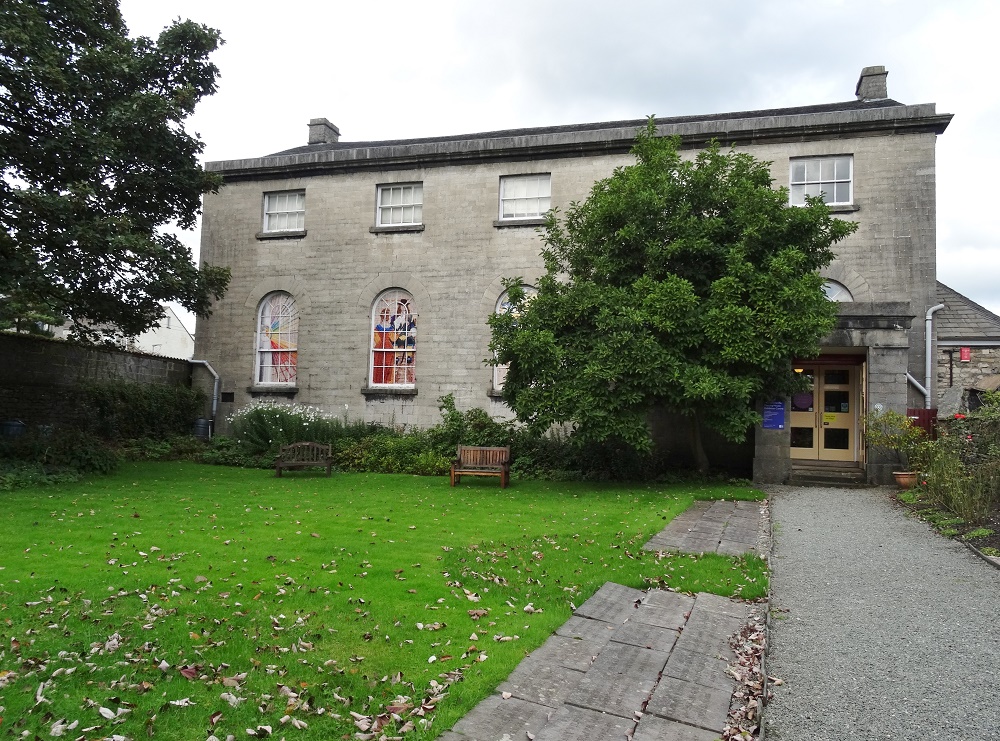
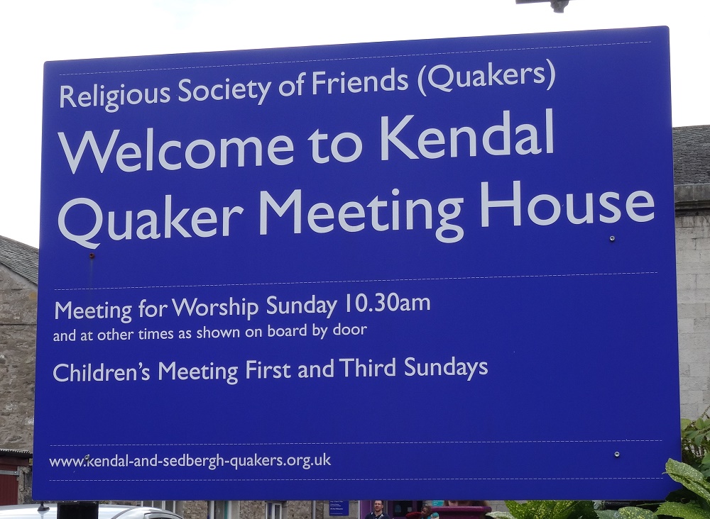
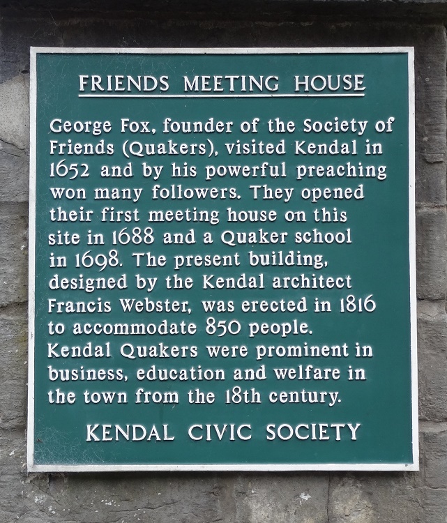
| Description | : | George Fox, founder of the Society of Friends (Quakers), visited Kendal in 1652 and by his powerful preaching won many followers. Meetings were originally held at private houses but in 1688 a meeting house was opened here at Stramongate. During the following century the premises were altered and enlarged but by 1814 it was decided that a completely new Meeting House was needed. The current building was opened in 1816, and not only is it still used for meetings; it is the home of the Quaker Tapestry Exhibition. As far as burials are concerned, it is known that the oldest site in... Read More |
frequently asked questions (FAQ):
-
Where is Kendal Quaker Meeting House?
Kendal Quaker Meeting House is located at Stramongate Kendal, South Lakeland District ,Cumbria , LA9 4BHEngland.
-
Kendal Quaker Meeting House cemetery's updated grave count on graveviews.com?
0 memorials
-
Where are the coordinates of the Kendal Quaker Meeting House?
Latitude: 54.3287200
Longitude: -2.7431900
Nearby Cemetories:
1. Kendal Unitarian Chapel Burial Ground
Kendal, South Lakeland District, England
Coordinate: 54.3287120, -2.7450940
2. Castle Street Cemetery
Kendal, South Lakeland District, England
Coordinate: 54.3301600, -2.7365160
3. St. Thomas Churchyard
Kendal, South Lakeland District, England
Coordinate: 54.3316130, -2.7489140
4. The Sepulchre Quaker Burial Ground
Kendal, South Lakeland District, England
Coordinate: 54.3270022, -2.7502978
5. Stricklandgate Methodist
Kendal, South Lakeland District, England
Coordinate: 54.3321160, -2.7493720
6. Holy Trinity Church
Kendal, South Lakeland District, England
Coordinate: 54.3223970, -2.7448770
7. Quaker Burial Ground
Kendal, South Lakeland District, England
Coordinate: 54.3278200, -2.7285500
8. Parkside Cemetery
Kendal, South Lakeland District, England
Coordinate: 54.3210870, -2.7362680
9. St. John The Baptist Cemetery Extension
Skelsmergh, South Lakeland District, England
Coordinate: 54.3519250, -2.7249650
10. St. John the Baptist Cemetery
Skelsmergh, South Lakeland District, England
Coordinate: 54.3521700, -2.7253800
11. St Oswald Churchyard
Burneside, South Lakeland District, England
Coordinate: 54.3546500, -2.7634950
12. St Mark's Churchyard
Natland, South Lakeland District, England
Coordinate: 54.2961380, -2.7374200
13. St. Stephen's Churchyard
New Hutton, South Lakeland District, England
Coordinate: 54.3156560, -2.6747130
14. Helsington Churchyard
Helsington, South Lakeland District, England
Coordinate: 54.2934390, -2.7871630
15. All Saints Churchyard
Underbarrow, South Lakeland District, England
Coordinate: 54.3262900, -2.8268240
16. St. Thomas' Churchyard
Crosscrake, South Lakeland District, England
Coordinate: 54.2763700, -2.7335300
17. St. Thomas' Churchyard
Selside, South Lakeland District, England
Coordinate: 54.3861600, -2.7169400
18. Crook Chapel of Saint Catherine
Crook, South Lakeland District, England
Coordinate: 54.3445250, -2.8477290
19. St. Catherine's Churchyard
Crook, South Lakeland District, England
Coordinate: 54.3480260, -2.8462220
20. St. Mary's Churchyard
Crosthwaite, South Lakeland District, England
Coordinate: 54.3129300, -2.8526100
21. Quaker Burial Ground - Grayrigg
Grayrigg, South Lakeland District, England
Coordinate: 54.3664563, -2.6483654
22. Crosthwaite Cemetery
Crosthwaite, South Lakeland District, England
Coordinate: 54.3126000, -2.8546900
23. St John the Evangelist Churchyard
Grayrigg, South Lakeland District, England
Coordinate: 54.3681500, -2.6501200
24. St James Churchyard
Staveley, South Lakeland District, England
Coordinate: 54.3801350, -2.8183670