
| Birth | : | 16 Aug 1914 Indiana, USA |
| Death | : | 20 Feb 2012 Sacramento County, California, USA |
| Burial | : | Mount Vernon Memorial Park, Fair Oaks, Sacramento County, USA |
| Coordinate | : | 38.6800003, -121.2566986 |
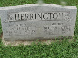
| Description | : | Alma died at age 97. She was a member of the Church of Christ. Survived by her sister, Lillie Sarpolis; brother, Charles Herrington(Marjorie); step-son Keith Ball(Marsha); daughter, Ann Garvin(Norman), daughter-in-law, Betty Herrington & Margaret Thompson; 10 grandchildren, 18 gr-grandchildren, and many other relatives & friends. Services: Feb 24, 2012, 12:00 noon, at Mount Vernon Memorial Park. (Source: Sacramento Bee Newspaper, Feb 23, 2012, pg. B-4) |
frequently asked questions (FAQ):
-
Where is Alma Finefrock Herrington Ball's memorial?
Alma Finefrock Herrington Ball's memorial is located at: Mount Vernon Memorial Park, Fair Oaks, Sacramento County, USA.
-
When did Alma Finefrock Herrington Ball death?
Alma Finefrock Herrington Ball death on 20 Feb 2012 in Sacramento County, California, USA
-
Where are the coordinates of the Alma Finefrock Herrington Ball's memorial?
Latitude: 38.6800003
Longitude: -121.2566986
Family Members:
Parent

Spouse

Siblings
Flowers:


Nearby Cemetories:
1. Mount Vernon Memorial Park
Fair Oaks, Sacramento County, USA
Coordinate: 38.6800003, -121.2566986
2. Sylvan Cemetery
Citrus Heights, Sacramento County, USA
Coordinate: 38.7001534, -121.2904587
3. Fair Oaks Cemetery
Fair Oaks, Sacramento County, USA
Coordinate: 38.6501167, -121.2792000
4. Fair Oaks United Methodist Church Memorial Garden
Fair Oaks, Sacramento County, USA
Coordinate: 38.6396300, -121.2744600
5. Calvary Catholic Cemetery and Mausoleum
Sacramento, Sacramento County, USA
Coordinate: 38.6937180, -121.3233109
6. Sierra Hills Memorial Park
Sacramento, Sacramento County, USA
Coordinate: 38.6843987, -121.3281021
7. China Mission-Chung Wah Chinese Cemetery
Folsom, Sacramento County, USA
Coordinate: 38.6698410, -121.1851790
8. Lakeside Memorial Lawn Cemetery
Folsom, Sacramento County, USA
Coordinate: 38.6715300, -121.1841000
9. Young Wo Cemetery
Folsom, Sacramento County, USA
Coordinate: 38.6733400, -121.1835000
10. Sierra Hills Pet Cemetery
Sacramento, Sacramento County, USA
Coordinate: 38.6863500, -121.3305300
11. Saint John the Baptist Catholic Church Cemetery
Folsom, Sacramento County, USA
Coordinate: 38.6721900, -121.1803000
12. F.O.E. 929 Cemetery
Folsom, Sacramento County, USA
Coordinate: 38.6717010, -121.1801010
13. Folsom Prison Cemetery
Folsom, Sacramento County, USA
Coordinate: 38.6952860, -121.1636690
14. Boothill Cemetery
Roseville, Placer County, USA
Coordinate: 38.7598730, -121.2712130
15. Roseville Public Cemetery District
Roseville, Placer County, USA
Coordinate: 38.7606010, -121.2707977
16. Kilgore Cemetery
Rancho Cordova, Sacramento County, USA
Coordinate: 38.5978012, -121.2683029
17. Carmichael Presbyterian Church Columbarium
Carmichael, Sacramento County, USA
Coordinate: 38.6179500, -121.3324500
18. Rocklin Cemetery
Rocklin, Placer County, USA
Coordinate: 38.7827670, -121.2337980
19. Saint Michaels Episcopal Church Columbarium
Carmichael, Sacramento County, USA
Coordinate: 38.6042800, -121.3547200
20. Mormon Island Relocation Cemetery
El Dorado Hills, El Dorado County, USA
Coordinate: 38.6986084, -121.1093521
21. Union Cemetery
Roseville, Placer County, USA
Coordinate: 38.7302600, -121.3924200
22. Saint Marks Methodist Church Memorial Tree
Sacramento, Sacramento County, USA
Coordinate: 38.6076500, -121.3750680
23. Shepherd of the Sierra Memorial Garden
Loomis, Placer County, USA
Coordinate: 38.7890800, -121.1944200
24. Kim Quang Temple Columbarium
Sacramento, Sacramento County, USA
Coordinate: 38.5996600, -121.3904700