


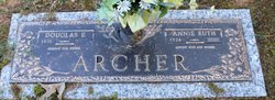
Annie Ruth Stevens Archer
| Birth | : | 10 Jul 1934 Stanly County, North Carolina, USA |
| Death | : | 24 Oct 2010 Albemarle, Stanly County, North Carolina, USA |
| Burial | : | St Peter and St Paul Churchyard, Lingfield, Tandridge District, England |
| Coordinate | : | 51.1763840, -0.0142480 |
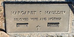
| Description | : | Albemarle - Annie Ruth Stevens Archer, of 1008 North 11th Street, Albemarle, passed away on October 24, 2010 at Stanly Regional Medical Center in Albemarle. The family will receive friends at Hartsell Funeral Home, Albemarle, Wednesday from 10:30 to 11:30 AM. At other times the family will meet at her home. Graveside service will be at Fariview Memorial Park on Wednesday at 12 PM. Born in Stanly County on July 10, 1934, she was the daughter of the late Margaret Stevens Mauldin. She was also preceded in death by her stepfather, Billy Edward Mauldin. She was a homemaker and a member of... Read More |
frequently asked questions (FAQ):
-
Where is Annie Ruth Stevens Archer's memorial?
Annie Ruth Stevens Archer's memorial is located at: St Peter and St Paul Churchyard, Lingfield, Tandridge District, England.
-
When did Annie Ruth Stevens Archer death?
Annie Ruth Stevens Archer death on 24 Oct 2010 in Albemarle, Stanly County, North Carolina, USA
-
Where are the coordinates of the Annie Ruth Stevens Archer's memorial?
Latitude: 51.1763840
Longitude: -0.0142480
Family Members:
Parent
Spouse
Siblings
Flowers:


Nearby Cemetories:
1. St Peter and St Paul Churchyard
Lingfield, Tandridge District, England
Coordinate: 51.1763840, -0.0142480
2. Dormansland Baptist Chapelyard
Dormansland, Tandridge District, England
Coordinate: 51.1634300, 0.0073300
3. St John the Evangelist Churchyard
Dormansland, Tandridge District, England
Coordinate: 51.1597320, 0.0054300
4. St. John the Evangelist Churchyard
Blindley Heath, Tandridge District, England
Coordinate: 51.1961510, -0.0536070
5. St John The Divine
Felbridge, Tandridge District, England
Coordinate: 51.1414480, -0.0392460
6. Mount Noddy Cemetery
East Grinstead, Mid Sussex District, England
Coordinate: 51.1316231, -0.0066281
7. St. Mary the Virgin Churchyard
Horne, Tandridge District, England
Coordinate: 51.1827330, -0.0886630
8. St. Swithun's Churchyard
East Grinstead, Mid Sussex District, England
Coordinate: 51.1240380, -0.0058020
9. St. Lawrence's Catholic Churchyard
Edenbridge, Sevenoaks District, England
Coordinate: 51.1951354, 0.0654156
10. St Peter and St Paul Churchyard
Edenbridge, Sevenoaks District, England
Coordinate: 51.1959000, 0.0661400
11. Edenbridge Cemetery
Edenbridge, Sevenoaks District, England
Coordinate: 51.1962400, 0.0680000
12. Smallfield Ebenezer Chapel Cemetery
Smallfield, Tandridge District, England
Coordinate: 51.1770230, -0.1151960
13. St John the Baptist Churchyard
Outwood, Tandridge District, England
Coordinate: 51.1981770, -0.1127510
14. St Peter Churchyard
Tandridge, Tandridge District, England
Coordinate: 51.2429480, -0.0320950
15. All Saints Churchyard
Crawley Down, Mid Sussex District, England
Coordinate: 51.1211200, -0.0830650
16. St Bartholomew Churchyard
Burstow, Tandridge District, England
Coordinate: 51.1558610, -0.1247750
17. St. Peter's Churchyard
Holtye, Wealden District, England
Coordinate: 51.1338783, 0.0821108
18. St John the Evangelist Churchyard
Copthorne, Crawley Borough, England
Coordinate: 51.1394100, -0.1175700
19. Saint Nicholas Churchyard
Godstone, Tandridge District, England
Coordinate: 51.2465740, -0.0567650
20. Cowden New Burial Ground
Cowden, Sevenoaks District, England
Coordinate: 51.1447210, 0.0958650
21. Holy Trinity Churchyard
Markbeech, Sevenoaks District, England
Coordinate: 51.1651750, 0.1077720
22. Hever Castle Grounds
Hever, Sevenoaks District, England
Coordinate: 51.1843770, 0.1111220
23. St Peter Churchyard
Hever, Sevenoaks District, England
Coordinate: 51.1838050, 0.1112430
24. Bletchingley Cemetery
Bletchingley, Tandridge District, England
Coordinate: 51.2411080, -0.0911120