
| Birth | : | 31 Mar 1824 Darmstadt, Stadtkreis Darmstadt, Hessen, Germany |
| Death | : | 22 Apr 1903 Champaign County, Ohio, USA |
| Burial | : | Sylvan Cemetery, Citrus Heights, Sacramento County, USA |
| Coordinate | : | 38.7001534, -121.2904587 |
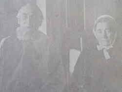
| Description | : | HERALD OF TRUTH, Vol. XL, No. 20, MAY 14, 1903 - PAGE 159-160 Bish John Warye- On the 22nd of April, 1903 five miles north of Urbana, Champaign Co., Ohio, Bishop John Warye at the age of 79 Y., 22 D. Deceased's death was due to a failure of health incident to his advanced age. He was born in Hesse Darmstadt, Germany, in 1824, emigrated with his parents to America in 1825, and located in Mifflin Co., Pa. He was united in marriage with Rebecca Lantz in 1849. To this union were born six sons and one daughter;two sons in infancy... Read More |
frequently asked questions (FAQ):
-
Where is Bishop John Warye's memorial?
Bishop John Warye's memorial is located at: Sylvan Cemetery, Citrus Heights, Sacramento County, USA.
-
When did Bishop John Warye death?
Bishop John Warye death on 22 Apr 1903 in Champaign County, Ohio, USA
-
Where are the coordinates of the Bishop John Warye's memorial?
Latitude: 38.7001534
Longitude: -121.2904587
Family Members:
Parent
Spouse

Siblings
Children
Flowers:


Nearby Cemetories:
1. Sylvan Cemetery
Citrus Heights, Sacramento County, USA
Coordinate: 38.7001534, -121.2904587
2. Calvary Catholic Cemetery and Mausoleum
Sacramento, Sacramento County, USA
Coordinate: 38.6937180, -121.3233109
3. Mount Vernon Memorial Park
Fair Oaks, Sacramento County, USA
Coordinate: 38.6800003, -121.2566986
4. Sierra Hills Memorial Park
Sacramento, Sacramento County, USA
Coordinate: 38.6843987, -121.3281021
5. Sierra Hills Pet Cemetery
Sacramento, Sacramento County, USA
Coordinate: 38.6863500, -121.3305300
6. Fair Oaks Cemetery
Fair Oaks, Sacramento County, USA
Coordinate: 38.6501167, -121.2792000
7. Boothill Cemetery
Roseville, Placer County, USA
Coordinate: 38.7598730, -121.2712130
8. Fair Oaks United Methodist Church Memorial Garden
Fair Oaks, Sacramento County, USA
Coordinate: 38.6396300, -121.2744600
9. Roseville Public Cemetery District
Roseville, Placer County, USA
Coordinate: 38.7606010, -121.2707977
10. Union Cemetery
Roseville, Placer County, USA
Coordinate: 38.7302600, -121.3924200
11. China Mission-Chung Wah Chinese Cemetery
Folsom, Sacramento County, USA
Coordinate: 38.6698410, -121.1851790
12. Young Wo Cemetery
Folsom, Sacramento County, USA
Coordinate: 38.6733400, -121.1835000
13. Lakeside Memorial Lawn Cemetery
Folsom, Sacramento County, USA
Coordinate: 38.6715300, -121.1841000
14. Carmichael Presbyterian Church Columbarium
Carmichael, Sacramento County, USA
Coordinate: 38.6179500, -121.3324500
15. Saint John the Baptist Catholic Church Cemetery
Folsom, Sacramento County, USA
Coordinate: 38.6721900, -121.1803000
16. F.O.E. 929 Cemetery
Folsom, Sacramento County, USA
Coordinate: 38.6717010, -121.1801010
17. Rocklin Cemetery
Rocklin, Placer County, USA
Coordinate: 38.7827670, -121.2337980
18. Folsom Prison Cemetery
Folsom, Sacramento County, USA
Coordinate: 38.6952860, -121.1636690
19. School House Park Cemetery
Roseville, Placer County, USA
Coordinate: 38.7893180, -121.3578670
20. Kilgore Cemetery
Rancho Cordova, Sacramento County, USA
Coordinate: 38.5978012, -121.2683029
21. Saint Michaels Episcopal Church Columbarium
Carmichael, Sacramento County, USA
Coordinate: 38.6042800, -121.3547200
22. Saint Marks Methodist Church Memorial Tree
Sacramento, Sacramento County, USA
Coordinate: 38.6076500, -121.3750680
23. Shepherd of the Sierra Memorial Garden
Loomis, Placer County, USA
Coordinate: 38.7890800, -121.1944200
24. Sunset Lawn Chapel of the Chimes Memorial Park
Sacramento, Sacramento County, USA
Coordinate: 38.6514816, -121.4384842