
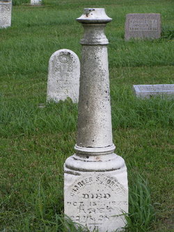

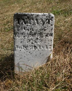
Charles Silas Horton
| Birth | : | 17 Sep 1850 Miami County, Indiana, USA |
| Death | : | 15 Oct 1877 Logansport, Cass County, Indiana, USA |
| Burial | : | St Hilda Churchyard, Danby, Scarborough Borough, England |
| Coordinate | : | 54.4475240, -0.9281480 |
| Plot | : | South Section, Row 12 |
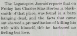
| Description | : | Published in the Rochester(IN) Union Spy, Friday, October 19, 1877 Just before going to press we received the shocking news through the Logansport PHAROS that Mr. C. S. HORTON, the well-known blacksmith and edge-tool maker, recently of Fulton, in this county, committed suicide by hanging in a hay loft. He moved to Logansport some two weeks ago for the purpose of entering more extensively in the business with a Mr. WOODWORTH. It seems from the letters left that he intended killing his wife also but later wrote her an affectionate letter and took his own life by hanging. He... Read More |
frequently asked questions (FAQ):
-
Where is Charles Silas Horton's memorial?
Charles Silas Horton's memorial is located at: St Hilda Churchyard, Danby, Scarborough Borough, England.
-
When did Charles Silas Horton death?
Charles Silas Horton death on 15 Oct 1877 in Logansport, Cass County, Indiana, USA
-
Where are the coordinates of the Charles Silas Horton's memorial?
Latitude: 54.4475240
Longitude: -0.9281480
Family Members:
Parent
Siblings
Flowers:


Nearby Cemetories:
1. St Hilda Churchyard
Danby, Scarborough Borough, England
Coordinate: 54.4475240, -0.9281480
2. Westerdale Green Burial Ground
Westerdale, Scarborough Borough, England
Coordinate: 54.4409040, -0.9555864
3. Quakers Burial Ground
Castleton, Scarborough Borough, England
Coordinate: 54.4614010, -0.9478360
4. Botton Village Cemetery
Danby, Scarborough Borough, England
Coordinate: 54.4290000, -0.9282700
5. Christ Church Churchyard Westerdale
Westerdale, Scarborough Borough, England
Coordinate: 54.4450870, -0.9781360
6. St Peter Churchyard
Commondale, Scarborough Borough, England
Coordinate: 54.4863700, -0.9766200
7. Glaisdale Head Methodist Church
Glaisdale, Scarborough Borough, England
Coordinate: 54.4294940, -0.8331749
8. Quaker Burial Ground
Lealholm, Scarborough Borough, England
Coordinate: 54.4575270, -0.8285030
9. St James the Greater Churchyard
Lealholm, Scarborough Borough, England
Coordinate: 54.4586200, -0.8240300
10. Our Lady of Sacred Heart Roman Catholic Churchyard
Lealholm, Scarborough Borough, England
Coordinate: 54.4592200, -0.8234600
11. St Thomas Churchyard
Glaisdale, Scarborough Borough, England
Coordinate: 54.4373700, -0.8083400
12. St Mary Churchyard
Moorsholm, Redcar and Cleveland Unitary Authority, England
Coordinate: 54.5207800, -0.9375800
13. St Mary Churchyard
Farndale East, Ryedale District, England
Coordinate: 54.3693000, -0.9663000
14. St Cuthbert Churchyard
Kildale, Hambleton District, England
Coordinate: 54.4779100, -1.0689200
15. St. Michael Churchyard
Liverton, Redcar and Cleveland Unitary Authority, England
Coordinate: 54.5370370, -0.9025160
16. Egton Cemetery
Egton, Scarborough Borough, England
Coordinate: 54.4482300, -0.7690700
17. St Mary and St Laurence Churchyard
Rosedale Abbey, Ryedale District, England
Coordinate: 54.3537300, -0.8872700
18. St. Nicholas' Churchyard
Bransdale, Ryedale District, England
Coordinate: 54.3777000, -1.0464000
19. St Aidan Churchyard
Boosbeck, Redcar and Cleveland Unitary Authority, England
Coordinate: 54.5428560, -0.9786800
20. Boosbeck Cemetery
Boosbeck, Redcar and Cleveland Unitary Authority, England
Coordinate: 54.5434900, -0.9779200
21. St Hilda Churchyard
Egton, Scarborough Borough, England
Coordinate: 54.4414240, -0.7535720
22. Christ Church Churchyard
Ugthorpe, Scarborough Borough, England
Coordinate: 54.4892300, -0.7672700
23. St. Andrew's Churchyard
Ingleby Greenhow, Hambleton District, England
Coordinate: 54.4487300, -1.1051300
24. St Nicholas Churchyard
Roxby, Scarborough Borough, England
Coordinate: 54.5365810, -0.8256590