
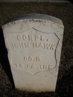

Corp John Nelson Hawk
| Birth | : | 29 Aug 1843 Scranton, Lackawanna County, Pennsylvania, USA |
| Death | : | 15 Aug 1917 Placer County, California, USA |
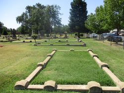
| Burial | : | Lincoln Cemetery, Lincoln, Placer County, USA |
| Coordinate | : | 38.8864310, -121.3020500 |
| Description | : | John N. Hawk was born in Scranton, PA. He served in the Union army during the Civil War in the 76th Pennsylvania Infantry was known as the "Keystone Zouves" from September 1861 to July 1865 "serving nearly four years and participating in some of the hardest battles of the war." He journeyed to California in 1875, and later married Ellen Holmes and had several children. He was a member of the I.O.O.F and the G.A.R. and served in many positions over the years. John Hawk was son of Samuel Hawk and Sarah Buchanan who were born... Read More |
frequently asked questions (FAQ):
-
Where is Corp John Nelson Hawk's memorial?
Corp John Nelson Hawk's memorial is located at: Lincoln Cemetery, Lincoln, Placer County, USA.
-
When did Corp John Nelson Hawk death?
Corp John Nelson Hawk death on 15 Aug 1917 in Placer County, California, USA
-
Where are the coordinates of the Corp John Nelson Hawk's memorial?
Latitude: 38.8864310
Longitude: -121.3020500
Family Members:
Spouse
Children

Flowers:


Nearby Cemetories:
1. Lincoln Cemetery
Lincoln, Placer County, USA
Coordinate: 38.8864310, -121.3020500
2. Santa Clara Memorial Park
Lincoln, Placer County, USA
Coordinate: 38.8894710, -121.3260560
3. Manzanita Cemetery
Lincoln, Placer County, USA
Coordinate: 38.9444008, -121.3032990
4. Whitney Family Mausoleum
Rocklin, Placer County, USA
Coordinate: 38.8256500, -121.2477000
5. Morgan Oaks Eternal Preserve
Lincoln, Placer County, USA
Coordinate: 38.9629050, -121.2860530
6. Gold Hill Cemetery
Gold Hill, Placer County, USA
Coordinate: 38.9025000, -121.1802200
7. Sheridan Cemetery
Sheridan, Placer County, USA
Coordinate: 38.9741000, -121.3585300
8. School House Park Cemetery
Roseville, Placer County, USA
Coordinate: 38.7893180, -121.3578670
9. Rocklin Cemetery
Rocklin, Placer County, USA
Coordinate: 38.7827670, -121.2337980
10. Newcastle Cemetery
Newcastle, Placer County, USA
Coordinate: 38.8708880, -121.1444060
11. Stewarts Flat Cemetery
Penryn, Placer County, USA
Coordinate: 38.8447360, -121.1507950
12. Roseville Public Cemetery District
Roseville, Placer County, USA
Coordinate: 38.7606010, -121.2707977
13. Shepherd of the Sierra Memorial Garden
Loomis, Placer County, USA
Coordinate: 38.7890800, -121.1944200
14. Boothill Cemetery
Roseville, Placer County, USA
Coordinate: 38.7598730, -121.2712130
15. Ophir Cemetery
Placer County, USA
Coordinate: 38.8928870, -121.1273790
16. Lone Star Cemetery
Placer County, USA
Coordinate: 38.9757996, -121.1380997
17. Camp Far West Cemetery
Wheatland, Yuba County, USA
Coordinate: 39.0395500, -121.3431400
18. Prosser Family Cemetery
Loomis, Placer County, USA
Coordinate: 38.8071900, -121.1285600
19. Mansur Family Cemetery
Loomis, Placer County, USA
Coordinate: 38.8139600, -121.1214000
20. Wheatland Cemetery
Wheatland, Yuba County, USA
Coordinate: 39.0083008, -121.4360962
21. New Auburn Cemetery
Auburn, Placer County, USA
Coordinate: 38.9026900, -121.0870800
22. Union Cemetery
Roseville, Placer County, USA
Coordinate: 38.7302600, -121.3924200
23. Old Auburn Cemetery
Auburn, Placer County, USA
Coordinate: 38.9023720, -121.0812230
24. Wells Cemetery
Auburn, Placer County, USA
Coordinate: 38.9667000, -121.1054900