
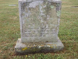
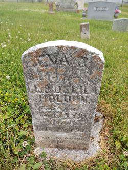
Delila Alilah Hill Holden
| Birth | : | 27 Feb 1891 |
| Death | : | 14 May 1920 |
| Burial | : | All Saints Churchyard, Lamport, Daventry District, England |
| Coordinate | : | 52.3637900, -0.8883600 |
| Inscription | : | Delila A. Hill wife of I. Luther Holden Feb. 27, 1891 May 14, 1920 My voice shalt Thou hear in the morning, O Lord; in the morn- ing will I direct my prayer unto Thee, and will look up |
frequently asked questions (FAQ):
-
Where is Delila Alilah Hill Holden's memorial?
Delila Alilah Hill Holden's memorial is located at: All Saints Churchyard, Lamport, Daventry District, England.
-
When did Delila Alilah Hill Holden death?
Delila Alilah Hill Holden death on 14 May 1920 in
-
Where are the coordinates of the Delila Alilah Hill Holden's memorial?
Latitude: 52.3637900
Longitude: -0.8883600
Family Members:
Parent
Spouse
Siblings
Children
Flowers:


Nearby Cemetories:
1. All Saints Churchyard
Lamport, Daventry District, England
Coordinate: 52.3637900, -0.8883600
2. St Peter and St Paul Churchyard
Scaldwell, Daventry District, England
Coordinate: 52.3459100, -0.8732100
3. Saint Catherine
Draughton, Daventry District, England
Coordinate: 52.3840770, -0.8821840
4. Saint Mary the Virgin
Maidwell, Daventry District, England
Coordinate: 52.3854950, -0.9007770
5. Independent Chapel Burial Yard
Old, Daventry District, England
Coordinate: 52.3514947, -0.8506201
6. Saint Andrew Churchyard
Old, Daventry District, England
Coordinate: 52.3503600, -0.8484200
7. Walgrave Cemetery
Walgrave, Daventry District, England
Coordinate: 52.3385720, -0.8314720
8. All Saints Churchyard
Cottesbrooke, Daventry District, England
Coordinate: 52.3552260, -0.9588300
9. St. Peter's Churchyard
Walgrave, Daventry District, England
Coordinate: 52.3404255, -0.8248900
10. St. Deny's Churchyard
Kelmarsh, Daventry District, England
Coordinate: 52.4060590, -0.9207120
11. Saint Michael's Churchyard
Haselbech, Daventry District, England
Coordinate: 52.3891890, -0.9556720
12. St. Mary & All Saints Churchyard
Holcot, Daventry District, England
Coordinate: 52.3208630, -0.8390120
13. St Andrew Churchyard
Spratton, Daventry District, England
Coordinate: 52.3243520, -0.9483460
14. All Saints Churchyard
Pitsford, Daventry District, England
Coordinate: 52.3066700, -0.8952200
15. All Saints Churchyard
Orton, Kettering Borough, England
Coordinate: 52.4068200, -0.8171200
16. Saint Leonard's Churchyard
Loddington, Kettering Borough, England
Coordinate: 52.3971985, -0.8041003
17. St Andrew Churchyard
Arthingworth, Daventry District, England
Coordinate: 52.4255400, -0.8914700
18. St Andrew's Church
Great Cransley, Kettering Borough, England
Coordinate: 52.3816667, -0.7850000
19. St James Churchyard
Hollowell, Daventry District, England
Coordinate: 52.3404638, -0.9912752
20. All Saints Churchyard
Naseby, Daventry District, England
Coordinate: 52.3968790, -0.9889740
21. All Saints Churchyard
Clipston, Daventry District, England
Coordinate: 52.4273400, -0.9517300
22. St Etheldreda Churchyard
Guilsborough, Daventry District, England
Coordinate: 52.3480310, -1.0089780
23. Rothwell Cemetery
Rothwell, Kettering Borough, England
Coordinate: 52.4165400, -0.8000300
24. St John the Baptist Churchyard
Boughton, Daventry District, England
Coordinate: 52.2861187, -0.8971496