
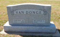
Edward Van Donge Jr.
| Birth | : | 9 Oct 1922 Hawarden, Sioux County, Iowa, USA |
| Death | : | 26 Feb 1991 Sioux City, Woodbury County, Iowa, USA |
| Burial | : | Holy Trinity, Godington, Cherwell District, England |
| Coordinate | : | 51.9452700, -1.0667470 |
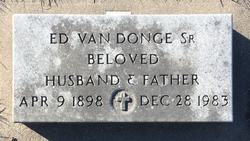
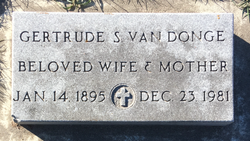
| Description | : | Edward Van Donge, 68, of Ireton died Tuesday, Feb. 26, 1991, at a Sioux City hospital. Services., were held at 2 p.m. Friday at the First Reformed, church of Ireton with the Rev. Steven Bakker officiating. Burial was in Pleasant Hill cemetery, under direction Porter-Dow funeral home in Ireton. Van Donge was born Oct. 9, 1922, in Hawarden, the son of Ed and Gertrude (Schut) Von Donge. He married Mildred Ten Napel Jan. 1, 1945, in Ireton. The couple farmed near Craig until moving to Ireton in 1979. He then worked for the Siouxland Implement Company in Ireton. |
frequently asked questions (FAQ):
-
Where is Edward Van Donge Jr.'s memorial?
Edward Van Donge Jr.'s memorial is located at: Holy Trinity, Godington, Cherwell District, England.
-
When did Edward Van Donge Jr. death?
Edward Van Donge Jr. death on 26 Feb 1991 in Sioux City, Woodbury County, Iowa, USA
-
Where are the coordinates of the Edward Van Donge Jr.'s memorial?
Latitude: 51.9452700
Longitude: -1.0667470
Family Members:
Parent
Spouse
Siblings
Flowers:


Nearby Cemetories:
1. Holy Trinity
Godington, Cherwell District, England
Coordinate: 51.9452700, -1.0667470
2. Ss Mary and Nicholas Churchyard
Chetwode, Aylesbury Vale District, England
Coordinate: 51.9630520, -1.0694610
3. Assumption of BVM Churchyard
Twyford, Aylesbury Vale District, England
Coordinate: 51.9345860, -1.0341060
4. St. John the Baptist Churchyard
Preston Bissett, Aylesbury Vale District, England
Coordinate: 51.9637380, -1.0440980
5. St James Churchyard
Barton Harthshorn, Aylesbury Vale District, England
Coordinate: 51.9730300, -1.0686650
6. St Michael & All Angels Churchyard
Newton Purcell, Cherwell District, England
Coordinate: 51.9723110, -1.0915630
7. St Michaels and All Angels Churchyard
Fringford, Cherwell District, England
Coordinate: 51.9573680, -1.1189880
8. SS Mary & Edburga Churchyard
Stratton Audley, Cherwell District, England
Coordinate: 51.9294810, -1.1164160
9. All Saints Churchyard
Hillesden, Aylesbury Vale District, England
Coordinate: 51.9582028, -1.0045972
10. St Mary the Virgin Churchyard
Marsh Gibbon, Aylesbury Vale District, England
Coordinate: 51.9038310, -1.0601060
11. Marsh Gibbon Cemetery
Bicester, Cherwell District, England
Coordinate: 51.9000250, -1.0607810
12. St. Edmund and St. George Churchyard
Hethe, Cherwell District, England
Coordinate: 51.9604830, -1.1384690
13. Tingewick Cemetery
Tingewick, Aylesbury Vale District, England
Coordinate: 51.9917800, -1.0514420
14. St. Michael and All Angels
Finmere, Cherwell District, England
Coordinate: 51.9931740, -1.0740240
15. St. Mary's Churchyard
Tingewick, Aylesbury Vale District, England
Coordinate: 51.9919690, -1.0432400
16. Holy Trinity Churchyard
Gawcott-with-Lenborough, Aylesbury Vale District, England
Coordinate: 51.9809000, -1.0114000
17. Holy Trinity Churchyard
Hethe, Cherwell District, England
Coordinate: 51.9615600, -1.1452100
18. Bethel Congregational Church
Launton, Cherwell District, England
Coordinate: 51.8979200, -1.1151020
19. St Michael and All Angels Churchyard
Edgcott, Aylesbury Vale District, England
Coordinate: 51.8995450, -1.0132210
20. St Marys Churchyard
Launton, Cherwell District, England
Coordinate: 51.9006740, -1.1230300
21. St. Mary's Churchyard
Cottisford, Cherwell District, England
Coordinate: 51.9749070, -1.1464410
22. St. Michael Churchyard
Steeple Claydon, Aylesbury Vale District, England
Coordinate: 51.9345150, -0.9752060
23. St Laurence Churchyard
Caversfield, Cherwell District, England
Coordinate: 51.9223030, -1.1571690
24. St Mary the Virgin Churchyard
Hardwick, Cherwell District, England
Coordinate: 51.9616750, -1.1615570