
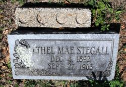
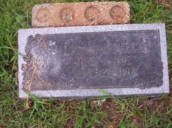
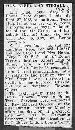
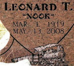
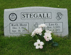
Ethel Mae Link Stegall
| Birth | : | 4 Dec 1892 Bonne Terre, St. Francois County, Missouri, USA |
| Death | : | 27 Sep 1963 Bonne Terre, St. Francois County, Missouri, USA |
| Burial | : | Methodist Protestant Cemetery (Defunct), Cincinnati, Hamilton County, USA |
| Coordinate | : | 39.1324770, -84.4983160 |
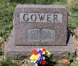
| Description | : | Wife of Charles Stegall Daughter of George Link & Elizabeth Easter |
frequently asked questions (FAQ):
-
Where is Ethel Mae Link Stegall's memorial?
Ethel Mae Link Stegall's memorial is located at: Methodist Protestant Cemetery (Defunct), Cincinnati, Hamilton County, USA.
-
When did Ethel Mae Link Stegall death?
Ethel Mae Link Stegall death on 27 Sep 1963 in Bonne Terre, St. Francois County, Missouri, USA
-
Where are the coordinates of the Ethel Mae Link Stegall's memorial?
Latitude: 39.1324770
Longitude: -84.4983160
Family Members:
Spouse

Children
Flowers:


Nearby Cemetories:
1. Methodist Protestant Cemetery (Defunct)
Cincinnati, Hamilton County, USA
Coordinate: 39.1324770, -84.4983160
2. Walnut Hills Cemetery
Cincinnati, Hamilton County, USA
Coordinate: 39.1355950, -84.4809040
3. First German Protestant Cemetery
Avondale, Hamilton County, USA
Coordinate: 39.1492004, -84.4863968
4. Vine Street Hill Cemetery
Cincinnati, Hamilton County, USA
Coordinate: 39.1516991, -84.5091019
5. Walnut Hills Jewish Cemetery
Evanston, Hamilton County, USA
Coordinate: 39.1403700, -84.4731300
6. Hillside Chapel Crematory and Columbarium
Cincinnati, Hamilton County, USA
Coordinate: 39.1393509, -84.5247192
7. Calvary Cemetery
Cincinnati, Hamilton County, USA
Coordinate: 39.1403008, -84.4697037
8. Christ Church Cemetery
Over-The-Rhine, Hamilton County, USA
Coordinate: 39.1126480, -84.5157623
9. Christ Episcopal Churchyard (Defunct)
Cincinnati, Hamilton County, USA
Coordinate: 39.1100520, -84.5177220
10. Thomas Williams Cemetery (Defunct)
Cincinnati, Hamilton County, USA
Coordinate: 39.1085060, -84.5146050
11. Potters Field
Cincinnati, Hamilton County, USA
Coordinate: 39.1094440, -84.5188890
12. Clifton United Jewish Cemetery
Cincinnati, Hamilton County, USA
Coordinate: 39.1470871, -84.5292816
13. Presbyterian Burying Ground
Cincinnati, Hamilton County, USA
Coordinate: 39.1082510, -84.5175720
14. Second Quaker Cemetery (Defunct)
Cincinnati, Hamilton County, USA
Coordinate: 39.1153090, -84.5305240
15. Chestnut Street Cemetery
Over-The-Rhine, Hamilton County, USA
Coordinate: 39.1071610, -84.5212210
16. Wesleyan Chapel Methodist Church Cemetery
Cincinnati, Hamilton County, USA
Coordinate: 39.1022390, -84.5073540
17. Christ Church Cathedral Columbarium
Cincinnati, Hamilton County, USA
Coordinate: 39.1009690, -84.5073790
18. Saint John Cemetery
Saint Bernard, Hamilton County, USA
Coordinate: 39.1643982, -84.5053024
19. Enon Baptist Church Burying Ground (Defunct)
Cincinnati, Hamilton County, USA
Coordinate: 39.1065420, -84.5238110
20. Catherine Street Methodist Cemetery (Defunct)
Cincinnati, Hamilton County, USA
Coordinate: 39.1064840, -84.5243150
21. Catherine Street Burying Ground
Cincinnati, Hamilton County, USA
Coordinate: 39.1067490, -84.5252700
22. First Presbyterian Church Cemetery
Cincinnati, Hamilton County, USA
Coordinate: 39.1005310, -84.5102830
23. Saint Mary Cemetery
Saint Bernard, Hamilton County, USA
Coordinate: 39.1664009, -84.4880981
24. Lincoln Park Potters Field (Defunct)
Cincinnati, Hamilton County, USA
Coordinate: 39.1097710, -84.5346450