
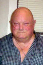
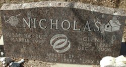

Glen R Nicholas
| Birth | : | 1 Jun 1927 Hand County, South Dakota, USA |
| Death | : | 7 Dec 2006 Pierre, Hughes County, South Dakota, USA |
| Burial | : | Grantham Cemetery and Crematorium, Grantham, South Kesteven District, England |
| Coordinate | : | 52.9095320, -0.6326120 |
| Plot | : | Section 2 Lot 176 Grave 4 |
| Description | : | Glen R. Nicholas, 79, of Pierre, died Thursday, Dec. 7, 2006 at St. Mary's Hospital in Pierre. Funeral services were held Tuesday, Dec. 12 at Isburg Funeral Chapel in Pierre. Burial was in Scotty Philip Cemetery. Glen was born June 1, 1927 in Hand County (at what is now Lake Louise) to Raleigh and Dollie (Walton) Nicholas. He grew up in Miller and attended country school in Hand County through the eighth grade. He joined the Army in 1950 and was discharged in 1959. Glen married Susanna Hendrich on April 2, 1955 in Germany. Glen worked as a ranch hand, in construction... Read More |
frequently asked questions (FAQ):
-
Where is Glen R Nicholas's memorial?
Glen R Nicholas's memorial is located at: Grantham Cemetery and Crematorium, Grantham, South Kesteven District, England.
-
When did Glen R Nicholas death?
Glen R Nicholas death on 7 Dec 2006 in Pierre, Hughes County, South Dakota, USA
-
Where are the coordinates of the Glen R Nicholas's memorial?
Latitude: 52.9095320
Longitude: -0.6326120
Family Members:
Parent

Spouse
Siblings
Flowers:


Nearby Cemetories:
1. Grantham Cemetery and Crematorium
Grantham, South Kesteven District, England
Coordinate: 52.9095320, -0.6326120
2. St. Wulfram Churchyard
Grantham, South Kesteven District, England
Coordinate: 52.9148180, -0.6408520
3. Manthorpe Road Old Cemetery
Grantham, South Kesteven District, England
Coordinate: 52.9173900, -0.6409900
4. St John the Evangelist Churchyard
Manthorpe, South Kesteven District, England
Coordinate: 52.9306320, -0.6323160
5. St. Guthlac Churchyard
Little Ponton, South Kesteven District, England
Coordinate: 52.8796100, -0.6271200
6. St Sebastian Churchyard
Great Gonerby, South Kesteven District, England
Coordinate: 52.9329260, -0.6657700
7. St John the Baptist Churchyard
Londonthorpe, South Kesteven District, England
Coordinate: 52.9312060, -0.5837350
8. St. Peter and St. Paul's Churchyard
Belton, South Kesteven District, England
Coordinate: 52.9451000, -0.6177000
9. All Saints Churchyard
Barrowby, South Kesteven District, England
Coordinate: 52.9186420, -0.6946810
10. St. Mary Magdalene Churchyard
Old Somerby, South Kesteven District, England
Coordinate: 52.8944900, -0.5672830
11. St Mary and St Peter Churchyard
Harlaxton, South Kesteven District, England
Coordinate: 52.8836860, -0.6895640
12. All Saints Churchyard
Stroxton, South Kesteven District, England
Coordinate: 52.8695300, -0.6609700
13. Holy Cross Churchyard
Great Ponton, South Kesteven District, England
Coordinate: 52.8638270, -0.6275570
14. St Marys Churchyard
Syston, South Kesteven District, England
Coordinate: 52.9578420, -0.6172940
15. St Nicholas Churchyard
Barkston, South Kesteven District, England
Coordinate: 52.9629960, -0.6129380
16. St Andrew Churchyard
Denton, South Kesteven District, England
Coordinate: 52.8828830, -0.7151840
17. St. Lawrence Churchyard
Sedgebrook, South Kesteven District, England
Coordinate: 52.9329460, -0.7256530
18. Saint Andrew Churchyard
Boothby Pagnell, South Kesteven District, England
Coordinate: 52.8660600, -0.5578600
19. St. Peter's Churchyard
Ropsley, South Kesteven District, England
Coordinate: 52.8959736, -0.5259958
20. Ropsley Churchyard Extension
Ropsley, South Kesteven District, England
Coordinate: 52.8958475, -0.5254147
21. St James Churchyard
Allington, South Kesteven District, England
Coordinate: 52.9525695, -0.7245301
22. St. Wilfrid Churchyard
Honington, South Kesteven District, England
Coordinate: 52.9795600, -0.5965700
23. St Thomas a Beckett Churchyard
Bassingthorpe, South Kesteven District, England
Coordinate: 52.8457500, -0.5669900
24. St James Churchyard
Woolsthorpe-by-Belvoir, South Kesteven District, England
Coordinate: 52.8957880, -0.7578370