

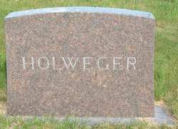
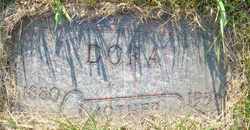
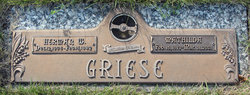
Gottlieb Holweger
| Birth | : | 30 Jan 1910 Pleasant View Township, Grand Forks County, North Dakota, USA |
| Death | : | 4 Jun 1992 |
| Burial | : | Calvary Catholic Cemetery and Mausoleum, Sacramento, Sacramento County, USA |
| Coordinate | : | 38.6937180, -121.3233109 |
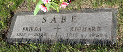
| Inscription | : | Son |
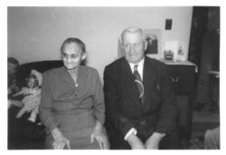
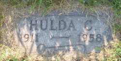
| Description | : | GOTTLIEB HOLWEGER: Newspaper Obituary and Death Notice Grand Forks Herald (ND) - Saturday, June 6, 1992 Deceased Name: GOTTLIEB HOLWEGER Gottlieb Holweger, 82, 2206 11th Ave. S., died Thursday, June 4, 1992, at home. Gottlieb Holweger was born Jan. 30, 1910, in Pleasant View Township, Grand Forks County, the son of Gottlieb and Dora Holweger. He farmed in Pleasant View Township until he retired. He married Hulda C. Holweger Nov. 17, 1932, in Emerado, N.D. She died in June 1958. Survivors are his daughters, Gertrude (Mrs. Delmer) Roeder, Thompson, N.D., stepson, Rick Holweger, Bismarck; six grandchildren; 14 great-grandchildren;... Read More |
frequently asked questions (FAQ):
-
Where is Gottlieb Holweger's memorial?
Gottlieb Holweger's memorial is located at: Calvary Catholic Cemetery and Mausoleum, Sacramento, Sacramento County, USA.
-
When did Gottlieb Holweger death?
Gottlieb Holweger death on 4 Jun 1992 in
-
Where are the coordinates of the Gottlieb Holweger's memorial?
Latitude: 38.6937180
Longitude: -121.3233109
Family Members:
Parent
Spouse
Siblings
Children
Flowers:


Nearby Cemetories:
1. Calvary Catholic Cemetery and Mausoleum
Sacramento, Sacramento County, USA
Coordinate: 38.6937180, -121.3233109
2. Sierra Hills Pet Cemetery
Sacramento, Sacramento County, USA
Coordinate: 38.6863500, -121.3305300
3. Sierra Hills Memorial Park
Sacramento, Sacramento County, USA
Coordinate: 38.6843987, -121.3281021
4. Sylvan Cemetery
Citrus Heights, Sacramento County, USA
Coordinate: 38.7001534, -121.2904587
5. Mount Vernon Memorial Park
Fair Oaks, Sacramento County, USA
Coordinate: 38.6800003, -121.2566986
6. Fair Oaks Cemetery
Fair Oaks, Sacramento County, USA
Coordinate: 38.6501167, -121.2792000
7. Union Cemetery
Roseville, Placer County, USA
Coordinate: 38.7302600, -121.3924200
8. Fair Oaks United Methodist Church Memorial Garden
Fair Oaks, Sacramento County, USA
Coordinate: 38.6396300, -121.2744600
9. Carmichael Presbyterian Church Columbarium
Carmichael, Sacramento County, USA
Coordinate: 38.6179500, -121.3324500
10. Boothill Cemetery
Roseville, Placer County, USA
Coordinate: 38.7598730, -121.2712130
11. Roseville Public Cemetery District
Roseville, Placer County, USA
Coordinate: 38.7606010, -121.2707977
12. Saint Michaels Episcopal Church Columbarium
Carmichael, Sacramento County, USA
Coordinate: 38.6042800, -121.3547200
13. Saint Marks Methodist Church Memorial Tree
Sacramento, Sacramento County, USA
Coordinate: 38.6076500, -121.3750680
14. School House Park Cemetery
Roseville, Placer County, USA
Coordinate: 38.7893180, -121.3578670
15. Sunset Lawn Chapel of the Chimes Memorial Park
Sacramento, Sacramento County, USA
Coordinate: 38.6514816, -121.4384842
16. Kilgore Cemetery
Rancho Cordova, Sacramento County, USA
Coordinate: 38.5978012, -121.2683029
17. Kim Quang Temple Columbarium
Sacramento, Sacramento County, USA
Coordinate: 38.5996600, -121.3904700
18. China Mission-Chung Wah Chinese Cemetery
Folsom, Sacramento County, USA
Coordinate: 38.6698410, -121.1851790
19. Lakeside Memorial Lawn Cemetery
Folsom, Sacramento County, USA
Coordinate: 38.6715300, -121.1841000
20. Young Wo Cemetery
Folsom, Sacramento County, USA
Coordinate: 38.6733400, -121.1835000
21. Rocklin Cemetery
Rocklin, Placer County, USA
Coordinate: 38.7827670, -121.2337980
22. Saint John the Baptist Catholic Church Cemetery
Folsom, Sacramento County, USA
Coordinate: 38.6721900, -121.1803000
23. F.O.E. 929 Cemetery
Folsom, Sacramento County, USA
Coordinate: 38.6717010, -121.1801010
24. Folsom Prison Cemetery
Folsom, Sacramento County, USA
Coordinate: 38.6952860, -121.1636690