
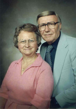
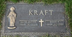
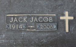
Jacob Joseph “Jack” Kraft
| Birth | : | 21 Feb 1914 Strasburg, Emmons County, North Dakota, USA |
| Death | : | 8 Apr 2006 King County, Washington, USA |
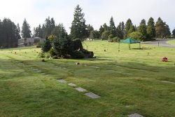
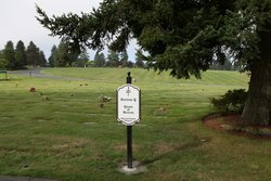
| Burial | : | Preston Old Cemetery, Ribbleton, City of Preston, England |
| Coordinate | : | 53.7686352, -2.6623154 |
| Plot | : | Section Q, Lot 920, Site 29 |
| Description | : | Husband of Rose (Blotske) Kraft. He entered into marriage with Rose Blotske on February 18, 1941 in Selfridge, North Dakota. He was the father of Marie Schmidt, Larry, Juliann Kraft, Patrick and Ronald J. Kraft. Father-in-law of Peter Schmidt, Ann Hansen, Frank Kraft, Dale Hogg and Shaughn Barron. Grandfather to Erik, Tor, Katherine, Douglas, Tina, Jack, Richard, Laura, Jody, Stephanie, Jacob, Travis and Rochelle Kraft. Grandfather to Paul, Genevieve and Marie Schmidt. |
frequently asked questions (FAQ):
-
Where is Jacob Joseph “Jack” Kraft's memorial?
Jacob Joseph “Jack” Kraft's memorial is located at: Preston Old Cemetery, Ribbleton, City of Preston, England.
-
When did Jacob Joseph “Jack” Kraft death?
Jacob Joseph “Jack” Kraft death on 8 Apr 2006 in King County, Washington, USA
-
Where are the coordinates of the Jacob Joseph “Jack” Kraft's memorial?
Latitude: 53.7686352
Longitude: -2.6623154
Family Members:
Parent

Spouse
Siblings
Children
Flowers:


Nearby Cemetories:
1. Preston Old Cemetery
Ribbleton, City of Preston, England
Coordinate: 53.7686352, -2.6623154
2. Preston New Cemetery
Ribbleton, City of Preston, England
Coordinate: 53.7717400, -2.6620900
3. St. Paul Churchyard
Preston, City of Preston, England
Coordinate: 53.7625360, -2.6947080
4. St. Ignatius RC Churchyard
Preston, City of Preston, England
Coordinate: 53.7635270, -2.6965870
5. St Leonard Churchyard
Walton-le-Dale, South Ribble Borough, England
Coordinate: 53.7476530, -2.6666950
6. St Augustine of Canterbury
Preston, City of Preston, England
Coordinate: 53.7560420, -2.6912650
7. St. James' Churchyard
Preston, City of Preston, England
Coordinate: 53.7566010, -2.6941110
8. St John Churchyard
Preston, City of Preston, England
Coordinate: 53.7582080, -2.6959750
9. St. Leonard the Less Churchyard
Samlesbury, South Ribble Borough, England
Coordinate: 53.7680000, -2.6237000
10. Preston Crematorium
Preston, City of Preston, England
Coordinate: 53.7863750, -2.6340170
11. Holy Trinity
Preston, City of Preston, England
Coordinate: 53.7613030, -2.7030580
12. Friends Meeting House Burial Ground (Defunct)
Preston, City of Preston, England
Coordinate: 53.7610250, -2.7030380
13. Christ Church Churchyard
Fulwood, City of Preston, England
Coordinate: 53.7771920, -2.7028700
14. St. George the Martyr
Preston, City of Preston, England
Coordinate: 53.7591220, -2.7025660
15. St. Mary's and St. John RC Churchyard, Southworth
Samlesbury, South Ribble Borough, England
Coordinate: 53.7676690, -2.6183400
16. St. Wilfrid's Catholic Cemetery
Preston, City of Preston, England
Coordinate: 53.7581670, -2.7044930
17. Saint Peter Churchyard
Preston, City of Preston, England
Coordinate: 53.7634100, -2.7080700
18. Grey Friars' Church
Preston, City of Preston, England
Coordinate: 53.7601480, -2.7084600
19. Christ Church Churchyard
Preston, City of Preston, England
Coordinate: 53.7573210, -2.7103080
20. All Saints Churchyard
Walton-le-Dale, South Ribble Borough, England
Coordinate: 53.7407250, -2.6408280
21. Our Lady and St Patrick's Church
Walton-le-Dale, South Ribble Borough, England
Coordinate: 53.7407250, -2.6408280
22. St Walburge's RC Church
Preston, City of Preston, England
Coordinate: 53.7629690, -2.7149620
23. St. Mary's Churchyard
Preston, City of Preston, England
Coordinate: 53.8010830, -2.6779600
24. St. Michael's Churchyard
Grimsargh, City of Preston, England
Coordinate: 53.7990710, -2.6352530