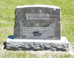
| Birth | : | 25 Oct 1843 |
| Death | : | 19 Apr 1924 Nuckolls County, Nebraska, USA |
| Burial | : | St. John the Baptist Churchyard, Church Preen, Shropshire Unitary Authority, England |
| Coordinate | : | 52.5792000, -2.6754000 |
| Plot | : | Block 18 Lot 5 Grave 5 Row 1 |
| Inscription | : | Mason Symbol April 2, 1883 |
| Description | : | JOHN Q. JOHNSTON John Q. Johnston, one of the real old timers of this county, died at his home just west of Oak, on last Saturday. He was 81 years and 6 months old and had been a resident of this county for more than forty years. He was at one time a member of our Board of County Commissioners. The funeral was held from the home Tuesday, the Rev. S.H. Jones of Nelson Presbyterian church (sic), officiating. The Masons conducted their ritualistic ceremony at the grave of their departed brother. Quite a number of the local Lodge... Read More |
frequently asked questions (FAQ):
-
Where is John Quincy Johnston Sr.'s memorial?
John Quincy Johnston Sr.'s memorial is located at: St. John the Baptist Churchyard, Church Preen, Shropshire Unitary Authority, England.
-
When did John Quincy Johnston Sr. death?
John Quincy Johnston Sr. death on 19 Apr 1924 in Nuckolls County, Nebraska, USA
-
Where are the coordinates of the John Quincy Johnston Sr.'s memorial?
Latitude: 52.5792000
Longitude: -2.6754000
Family Members:
Spouse
Children
Flowers:
Nearby Cemetories:
1. St. John the Baptist Churchyard
Church Preen, Shropshire Unitary Authority, England
Coordinate: 52.5792000, -2.6754000
2. St. John’s Churchyard
Hughley, Shropshire Unitary Authority, England
Coordinate: 52.5774550, -2.6435850
3. St. John The Baptist Churchyard
Kenley, Shropshire Unitary Authority, England
Coordinate: 52.6030460, -2.6469840
4. St Peter's Churchyard
Easthope, Shropshire Unitary Authority, England
Coordinate: 52.5522350, -2.6413020
5. St. Mary's Churchyard
Acton Burnell, Shropshire Unitary Authority, England
Coordinate: 52.6131390, -2.6907390
6. St. Mark's Churchyard
Frodesley, Shropshire Unitary Authority, England
Coordinate: 52.6052775, -2.7166580
7. St. James's Churchyard
Cardington, Shropshire Unitary Authority, England
Coordinate: 52.5520200, -2.7296220
8. Holy Trinity Churchyard
Bourton, Shropshire Unitary Authority, England
Coordinate: 52.5636887, -2.5957174
9. St. Mary's Churchyard
Harley, Shropshire Unitary Authority, England
Coordinate: 52.6094750, -2.5976600
10. St Peter's Church
Cound, Shropshire Unitary Authority, England
Coordinate: 52.6409160, -2.6542780
11. Christ Church Churchyard
Cressage, Shropshire Unitary Authority, England
Coordinate: 52.6322770, -2.6040810
12. Holy Trinity Churchyard
Holdgate, Shropshire Unitary Authority, England
Coordinate: 52.5024450, -2.6471900
13. All Saints Churchyard
Berrington, Shropshire Unitary Authority, England
Coordinate: 52.6574020, -2.6957330
14. St. Andrew's Churchyard
Hope Bowdler, Shropshire Unitary Authority, England
Coordinate: 52.5271160, -2.7739830
15. St. Mary & St. Andrew Churchyard
Condover, Shropshire Unitary Authority, England
Coordinate: 52.6474199, -2.7484076
16. Eaton- under- Heywood St Edith
Eaton-under-Heywood, Shropshire Unitary Authority, England
Coordinate: 52.5056520, -2.7382880
17. St. Mary's Churchyard
Acton Round, Shropshire Unitary Authority, England
Coordinate: 52.5573080, -2.5406470
18. St. John’s Churchyard
Condover, Shropshire Unitary Authority, England
Coordinate: 52.6356110, -2.7833220
19. St Laurence Churchyard
Church Stretton, Shropshire Unitary Authority, England
Coordinate: 52.5381750, -2.8087400
20. Church Stretton Cemetery
Church Stretton, Shropshire Unitary Authority, England
Coordinate: 52.5365590, -2.8097950
21. Greenhills Cemetery
Church Stretton, Shropshire Unitary Authority, England
Coordinate: 52.5310170, -2.8142480
22. St. Eata's Churchyard
Atcham, Shropshire Unitary Authority, England
Coordinate: 52.6785350, -2.6803958
23. St. John The Baptist Churchyard
Ditton Priors, Shropshire Unitary Authority, England
Coordinate: 52.4990090, -2.5784720
24. Holy Trinity Churchyard
Buildwas, Shropshire Unitary Authority, England
Coordinate: 52.6393710, -2.5380180


