
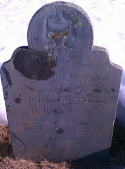
John Sherman
| Birth | : | 19 Jul 1720 Marshfield, Plymouth County, Massachusetts, USA |
| Death | : | 17 Dec 1800 Carver, Plymouth County, Massachusetts, USA |
| Burial | : | Bishops Corner Cemetery, Southbridge, Selwyn District, New Zealand |
| Coordinate | : | -43.7824100, 172.2422900 |
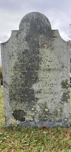
| Description | : | Son of William Sherman 1672-1739 and Mercy White 1670-1739. Grandson of William Sherman and Desire Doty, Peregrine White and Sarah Bassett. Husband of Elizabeth Dingley, the daughter of John Dingley and Sarah Porter. John and Elizabeth were married 21 August 1746 in Marshfield and had the following children: * Capt Nathaniel Sherman born 9 Feb 1748 Marshfield, Plymouth, MA, died 11 Jul 1829. Nathaniel married Mariah Clark 30 Nov 1769 at Plymouth County, MA. From the union of Nathaniel and Mariah were born the following known issues: 1. Elizabeth Sherman born 18 Jan 1770 Plympton, MA. Married John Prince 22 Aug 1790. Died 28... Read More |
frequently asked questions (FAQ):
-
Where is John Sherman's memorial?
John Sherman's memorial is located at: Bishops Corner Cemetery, Southbridge, Selwyn District, New Zealand.
-
When did John Sherman death?
John Sherman death on 17 Dec 1800 in Carver, Plymouth County, Massachusetts, USA
-
Where are the coordinates of the John Sherman's memorial?
Latitude: -43.7824100
Longitude: 172.2422900
Family Members:
Parent
Spouse
Siblings
Children

Flowers:


Nearby Cemetories:
1. Ellesmere Public Cemetery
Leeston, Selwyn District, New Zealand
Coordinate: -43.7775690, 172.2599220
2. Ellesmere Catholic Cemetery
Leeston, Selwyn District, New Zealand
Coordinate: -43.7845860, 172.2690990
3. St James Churchyard
Southbridge, Selwyn District, New Zealand
Coordinate: -43.8092360, 172.2502680
4. Killinchy Cemetery
Leeston, Selwyn District, New Zealand
Coordinate: -43.7325610, 172.2411540
5. Sedgemere Cemetery
Sedgemere, Selwyn District, New Zealand
Coordinate: -43.8366600, 172.3149500
6. St Luke's Anglican Churchyard
Brookside, Selwyn District, New Zealand
Coordinate: -43.6903100, 172.3029000
7. Brookside Cemetery
Brookside, Selwyn District, New Zealand
Coordinate: -43.6751800, 172.2683700
8. Hone Wetere Churchyard
Taumutu, Selwyn District, New Zealand
Coordinate: -43.8567680, 172.3586330
9. Dunsandel Cemetery
Dunsandel, Selwyn District, New Zealand
Coordinate: -43.6710940, 172.1382620
10. Dorie Cemetery
Dorie, Ashburton District, New Zealand
Coordinate: -43.8772900, 172.0862500
11. Kyle Cemetery
Dorie, Ashburton District, New Zealand
Coordinate: -43.9193236, 172.0979192
12. Rakaia Cemetery
Rakaia, Ashburton District, New Zealand
Coordinate: -43.7548910, 171.9939270
13. St Mary's Churchyard
Springston, Selwyn District, New Zealand
Coordinate: -43.6446560, 172.4263590
14. Springston Cemetery
Lincoln, Selwyn District, New Zealand
Coordinate: -43.6404360, 172.4509420
15. Chertsey Cemetery
Chertsey, Ashburton District, New Zealand
Coordinate: -43.8030500, 171.9319400
16. Lincoln Cemetery
Lincoln, Selwyn District, New Zealand
Coordinate: -43.6311790, 172.4862570
17. Weedons Cemetery
Weedons, Selwyn District, New Zealand
Coordinate: -43.5670010, 172.4015870
18. Greendale Cemetery
Greendale, Selwyn District, New Zealand
Coordinate: -43.5447560, 172.0772460
19. Shands Road Cemetery
Prebbleton, Selwyn District, New Zealand
Coordinate: -43.5792540, 172.4888630
20. Prebbleton Cemetery
Prebbleton, Selwyn District, New Zealand
Coordinate: -43.5887200, 172.5053500
21. St Paul's Anglican Church Cemetery
West Melton, Selwyn District, New Zealand
Coordinate: -43.5261700, 172.3701800
22. All Saint's Churchyard
Prebbleton, Selwyn District, New Zealand
Coordinate: -43.5781040, 172.5131430
23. Church of the Epiphany Churchyard
Teddington, Christchurch City, New Zealand
Coordinate: -43.7016200, 172.6182200
24. St Saviours Churchyard
Templeton, Christchurch City, New Zealand
Coordinate: -43.5501420, 172.4714620