

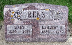
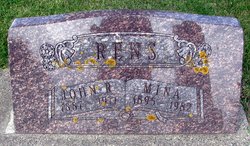
Lammert R. Rens
| Birth | : | 5 Mar 1885 Sioux Center, Sioux County, Iowa, USA |
| Death | : | 22 Dec 1962 Orange City, Sioux County, Iowa, USA |
| Burial | : | St Hilda Churchyard, Danby, Scarborough Borough, England |
| Coordinate | : | 54.4475240, -0.9281480 |
| Description | : | Lammert R. Rens passed away at the Orange City hospital Saturday, December 22, after a brief illness at the age of 77 years, 9 months and 17 days. He was a son of the late Reyer Rens and Engeltjie Van Sloten, and was born on a farm near Sioux Center on March 5, 1885. At a very young age, he with his parents, moved onto a farm three miles south of Hull. On October 23, 1913, he was united in marriage to Mary Willemsen, who preceded him in death on November 15, 1957. They lived on this farm until their retirement in... Read More |
frequently asked questions (FAQ):
-
Where is Lammert R. Rens's memorial?
Lammert R. Rens's memorial is located at: St Hilda Churchyard, Danby, Scarborough Borough, England.
-
When did Lammert R. Rens death?
Lammert R. Rens death on 22 Dec 1962 in Orange City, Sioux County, Iowa, USA
-
Where are the coordinates of the Lammert R. Rens's memorial?
Latitude: 54.4475240
Longitude: -0.9281480
Family Members:
Parent
Spouse
Siblings

Children
Flowers:


Nearby Cemetories:
1. St Hilda Churchyard
Danby, Scarborough Borough, England
Coordinate: 54.4475240, -0.9281480
2. Westerdale Green Burial Ground
Westerdale, Scarborough Borough, England
Coordinate: 54.4409040, -0.9555864
3. Quakers Burial Ground
Castleton, Scarborough Borough, England
Coordinate: 54.4614010, -0.9478360
4. Botton Village Cemetery
Danby, Scarborough Borough, England
Coordinate: 54.4290000, -0.9282700
5. Christ Church Churchyard Westerdale
Westerdale, Scarborough Borough, England
Coordinate: 54.4450870, -0.9781360
6. St Peter Churchyard
Commondale, Scarborough Borough, England
Coordinate: 54.4863700, -0.9766200
7. Glaisdale Head Methodist Church
Glaisdale, Scarborough Borough, England
Coordinate: 54.4294940, -0.8331749
8. Quaker Burial Ground
Lealholm, Scarborough Borough, England
Coordinate: 54.4575270, -0.8285030
9. St James the Greater Churchyard
Lealholm, Scarborough Borough, England
Coordinate: 54.4586200, -0.8240300
10. Our Lady of Sacred Heart Roman Catholic Churchyard
Lealholm, Scarborough Borough, England
Coordinate: 54.4592200, -0.8234600
11. St Thomas Churchyard
Glaisdale, Scarborough Borough, England
Coordinate: 54.4373700, -0.8083400
12. St Mary Churchyard
Moorsholm, Redcar and Cleveland Unitary Authority, England
Coordinate: 54.5207800, -0.9375800
13. St Mary Churchyard
Farndale East, Ryedale District, England
Coordinate: 54.3693000, -0.9663000
14. St Cuthbert Churchyard
Kildale, Hambleton District, England
Coordinate: 54.4779100, -1.0689200
15. St. Michael Churchyard
Liverton, Redcar and Cleveland Unitary Authority, England
Coordinate: 54.5370370, -0.9025160
16. Egton Cemetery
Egton, Scarborough Borough, England
Coordinate: 54.4482300, -0.7690700
17. St Mary and St Laurence Churchyard
Rosedale Abbey, Ryedale District, England
Coordinate: 54.3537300, -0.8872700
18. St. Nicholas' Churchyard
Bransdale, Ryedale District, England
Coordinate: 54.3777000, -1.0464000
19. St Aidan Churchyard
Boosbeck, Redcar and Cleveland Unitary Authority, England
Coordinate: 54.5428560, -0.9786800
20. Boosbeck Cemetery
Boosbeck, Redcar and Cleveland Unitary Authority, England
Coordinate: 54.5434900, -0.9779200
21. St Hilda Churchyard
Egton, Scarborough Borough, England
Coordinate: 54.4414240, -0.7535720
22. Christ Church Churchyard
Ugthorpe, Scarborough Borough, England
Coordinate: 54.4892300, -0.7672700
23. St. Andrew's Churchyard
Ingleby Greenhow, Hambleton District, England
Coordinate: 54.4487300, -1.1051300
24. St Nicholas Churchyard
Roxby, Scarborough Borough, England
Coordinate: 54.5365810, -0.8256590