
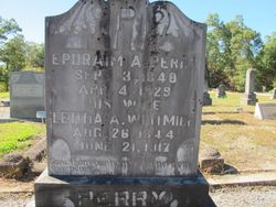

Leticia A Whitmire Perry
| Birth | : | 26 Aug 1844 Pickens County, South Carolina, USA |
| Death | : | 21 Jun 1917 Keowee, Oconee County, South Carolina, USA |
| Burial | : | St. Helen's Churchyard, Wheathampstead, St Albans District, England |
| Coordinate | : | 51.8124510, -0.2946400 |
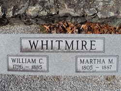
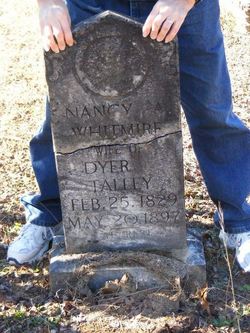
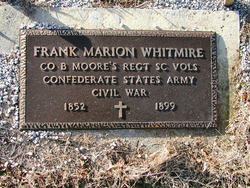
| Description | : | Wife of Ephraim A. Perry. Daughter of William Carlisle Whitmire and Martha J. McAfee. |
frequently asked questions (FAQ):
-
Where is Leticia A Whitmire Perry's memorial?
Leticia A Whitmire Perry's memorial is located at: St. Helen's Churchyard, Wheathampstead, St Albans District, England.
-
When did Leticia A Whitmire Perry death?
Leticia A Whitmire Perry death on 21 Jun 1917 in Keowee, Oconee County, South Carolina, USA
-
Where are the coordinates of the Leticia A Whitmire Perry's memorial?
Latitude: 51.8124510
Longitude: -0.2946400
Family Members:
Parent
Spouse

Siblings

Children

Flowers:


Nearby Cemetories:
1. St. Helen's Churchyard
Wheathampstead, St Albans District, England
Coordinate: 51.8124510, -0.2946400
2. Wheathampstead United Churchyard
Wheathampstead, St Albans District, England
Coordinate: 51.8108170, -0.2972210
3. St Lawrence Churchyard
Ayot St Lawrence, Welwyn Hatfield District, England
Coordinate: 51.8379490, -0.2717340
4. Ayot St Lawrence Old Churchyard
Ayot St Lawrence, Welwyn Hatfield District, England
Coordinate: 51.8377038, -0.2678795
5. St Leonard Churchyard & Extension
Sandridge, St Albans District, England
Coordinate: 51.7813690, -0.3036580
6. St Peter Churchyard
Ayot St Peter, Welwyn Hatfield District, England
Coordinate: 51.8201700, -0.2331800
7. Westfield Road Cemetery
Harpenden, St Albans District, England
Coordinate: 51.8270720, -0.3540300
8. St Nicholas Churchyard
Harpenden, St Albans District, England
Coordinate: 51.8169470, -0.3583300
9. Ss Peter and Paul Churchyard
Kimpton, North Hertfordshire District, England
Coordinate: 51.8527990, -0.2918240
10. St John the Evangelist Churchyard
Lemsford, Welwyn Hatfield District, England
Coordinate: 51.7934510, -0.2355890
11. National Children's Home Cemetery
Harpenden, St Albans District, England
Coordinate: 51.8305000, -0.3563000
12. St Mary Churchyard
Childwickbury, St Albans District, England
Coordinate: 51.7836980, -0.3473020
13. Childwickbury Manor
Childwickbury, St Albans District, England
Coordinate: 51.7809460, -0.3499100
14. Welwyn Cemetery
Welwyn, Welwyn Hatfield District, England
Coordinate: 51.8331340, -0.2199520
15. St. Mary's Churchyard
Welwyn, Welwyn Hatfield District, England
Coordinate: 51.8311660, -0.2151400
16. Holy Trinity Churchyard
East Hyde, Central Bedfordshire Unitary Authority, England
Coordinate: 51.8433710, -0.3640760
17. St John the Evangelist Churchyard
Digswell, Welwyn Hatfield District, England
Coordinate: 51.8186190, -0.2051940
18. Hatfield Road Cemetery
St Albans, St Albans District, England
Coordinate: 51.7523003, -0.3192620
19. St Peter's Churchyard
St Albans, St Albans District, England
Coordinate: 51.7555400, -0.3350270
20. St. Luke's Churchyard
Hatfield, Welwyn Hatfield District, England
Coordinate: 51.7643980, -0.2237710
21. Dagnall Lane Baptist Chapel
St Albans, St Albans District, England
Coordinate: 51.7526990, -0.3405156
22. Spicer Street Chapel Burial Ground
St Albans, St Albans District, England
Coordinate: 51.7523288, -0.3423231
23. Romeland Hill Garden of Rest
St Albans, St Albans District, England
Coordinate: 51.7514540, -0.3438830
24. Saint Alban's Cathedral
St Albans, St Albans District, England
Coordinate: 51.7504425, -0.3423680