
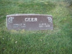


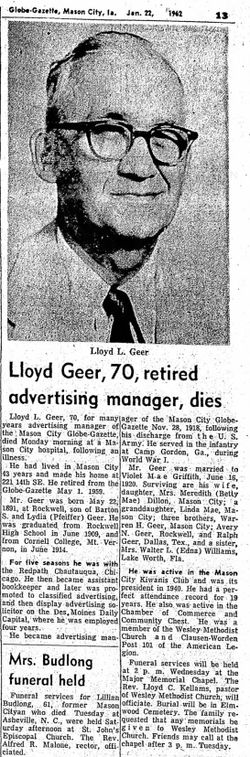
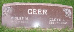
Lloyd Leslie Geer
| Birth | : | 22 May 1891 Rockwell, Cerro Gordo County, Iowa, USA |
| Death | : | 22 Jan 1962 Mason City, Cerro Gordo County, Iowa, USA |
| Burial | : | St Mary the Virgin Churchyard, Kemsing, Sevenoaks District, England |
| Coordinate | : | 51.3068670, 0.2310220 |
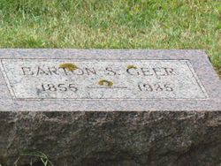
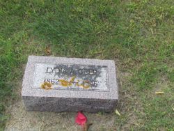
| Description | : | He married Violet Mae Griffith June 16, 1920 in Mason City, Cerro County, Iowa. His parents were Barton Silas Geer & Lydia A. Pfeiffer. |
frequently asked questions (FAQ):
-
Where is Lloyd Leslie Geer's memorial?
Lloyd Leslie Geer's memorial is located at: St Mary the Virgin Churchyard, Kemsing, Sevenoaks District, England.
-
When did Lloyd Leslie Geer death?
Lloyd Leslie Geer death on 22 Jan 1962 in Mason City, Cerro Gordo County, Iowa, USA
-
Where are the coordinates of the Lloyd Leslie Geer's memorial?
Latitude: 51.3068670
Longitude: 0.2310220
Family Members:
Parent
Spouse
Siblings
Flowers:


Nearby Cemetories:
1. St Mary the Virgin Churchyard
Kemsing, Sevenoaks District, England
Coordinate: 51.3068670, 0.2310220
2. St Peter and St Paul Churchyard
Seal, Sevenoaks District, England
Coordinate: 51.2907080, 0.2223010
3. St Mary's Churchyard Woodlands
West Kingsdown, Sevenoaks District, England
Coordinate: 51.3233700, 0.2428600
4. Greatness Park Cemetery
Sevenoaks, Sevenoaks District, England
Coordinate: 51.2906800, 0.2043260
5. St. Bartholomew's Churchyard
Otford, Sevenoaks District, England
Coordinate: 51.3123700, 0.1916890
6. St. Lawrence Churchyard
Seal Chart, Sevenoaks District, England
Coordinate: 51.2742910, 0.2537250
7. St Peter Churchyard
Ightham, Tonbridge and Malling Borough, England
Coordinate: 51.2891680, 0.2858450
8. Sevenoaks War Memorial
Sevenoaks, Sevenoaks District, England
Coordinate: 51.2761078, 0.1927860
9. St. Peter and St. Paul's Churchyard
Shoreham, Sevenoaks District, England
Coordinate: 51.3330170, 0.1844590
10. St Mary's
Dunton Green, Sevenoaks District, England
Coordinate: 51.2986100, 0.1632100
11. St Mary the Virgin Churchyard
Riverhead, Sevenoaks District, England
Coordinate: 51.2840040, 0.1707580
12. St Nicholas Churchyard
Sevenoaks, Sevenoaks District, England
Coordinate: 51.2673310, 0.1933100
13. Church of the Good Shepherd
Borough Green, Tonbridge and Malling Borough, England
Coordinate: 51.2910300, 0.3037660
14. Borough Green Baptist Churchyard
Borough Green, Tonbridge and Malling Borough, England
Coordinate: 51.2916540, 0.3053750
15. OMF International UK
Borough Green, Tonbridge and Malling Borough, England
Coordinate: 51.2937286, 0.3066902
16. Wrotham Cemetery
Wrotham, Tonbridge and Malling Borough, England
Coordinate: 51.3099430, 0.3108890
17. St George Churchyard
Wrotham, Tonbridge and Malling Borough, England
Coordinate: 51.3088360, 0.3110130
18. Ightham Mote
Ightham, Tonbridge and Malling Borough, England
Coordinate: 51.2584610, 0.2695830
19. St Mary the Virgin Churchyard
Stansted, Tonbridge and Malling Borough, England
Coordinate: 51.3355120, 0.3060170
20. Chevening Parish Burial Ground
Chevening, Sevenoaks District, England
Coordinate: 51.2987450, 0.1356290
21. St Botolph Churchyard
Chevening, Sevenoaks District, England
Coordinate: 51.2987650, 0.1345180
22. St. Margaret's Churchyard
Underriver, Sevenoaks District, England
Coordinate: 51.2458191, 0.2291520
23. St Mary the Virgin Churchyard
Platt, Tonbridge and Malling Borough, England
Coordinate: 51.2892070, 0.3252260
24. St Martin Churchyard
Eynsford, Sevenoaks District, England
Coordinate: 51.3675308, 0.2112560