
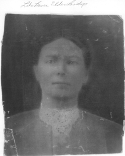


Lula Bruce Elder Bishop
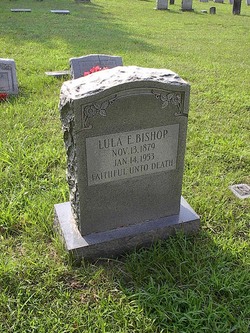
| Birth | : | 13 Nov 1879 Darvills, Dinwiddie County, Virginia, USA |
| Death | : | 14 Jan 1953 Darvills, Dinwiddie County, Virginia, USA |
| Burial | : | Aaron Clark Memorial Cemetery, Montague, Franklin County, USA |
| Coordinate | : | 42.5836200, -72.5471600 |
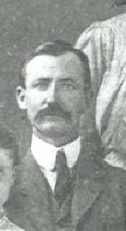
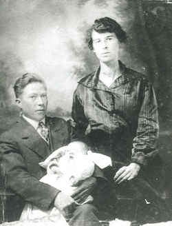
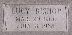
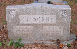
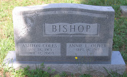
| Description | : | Lula Bruce Elder was the daughter of Hattie Thomas (Dyson) Elder (of Nottoway Co) and Charles Edward Elder(of Lunenburg Co). Hattie and Charles married in Nottoway and moved to Dinwiddie, Lula Bruce was their eldest child. Lula, for her entire life, was called by her middle name "Bruce" (a family surname). She was the sister of Edward B Elder, Lottie I Elder, George F Elder, and Charles T Elder. Lula Bruce married Edward Stokes Bishop on 4 Mar 1896 in Dinwiddie. They were the parents of: John Alfred Bishop, Lucy Thomas Bishop, Mary Gee... Read More |
frequently asked questions (FAQ):
-
Where is Lula Bruce Elder Bishop's memorial?
Lula Bruce Elder Bishop's memorial is located at: Aaron Clark Memorial Cemetery, Montague, Franklin County, USA.
-
When did Lula Bruce Elder Bishop death?
Lula Bruce Elder Bishop death on 14 Jan 1953 in Darvills, Dinwiddie County, Virginia, USA
-
Where are the coordinates of the Lula Bruce Elder Bishop's memorial?
Latitude: 42.5836200
Longitude: -72.5471600
Family Members:
Parent
Spouse
Children
Flowers:


Nearby Cemetories:
1. Aaron Clark Memorial Cemetery
Montague, Franklin County, USA
Coordinate: 42.5836200, -72.5471600
2. Our Lady of Czestochowa Cemetery
Montague, Franklin County, USA
Coordinate: 42.5846000, -72.5469400
3. Saint Marys Cemetery
Montague, Franklin County, USA
Coordinate: 42.5852200, -72.5475100
4. Saint Annes Cemetery
Montague, Franklin County, USA
Coordinate: 42.5861300, -72.5480600
5. Springdale Cemetery
Montague, Franklin County, USA
Coordinate: 42.5884700, -72.5530900
6. Fairway Avenue Cemetery
Montague, Franklin County, USA
Coordinate: 42.5924270, -72.5646970
7. Burnham Cemetery
Montague, Franklin County, USA
Coordinate: 42.5875300, -72.5720140
8. East Mineral Road Cemetery
Montague, Franklin County, USA
Coordinate: 42.5810500, -72.5086300
9. Highland Cemetery
Montague, Franklin County, USA
Coordinate: 42.5778008, -72.5083008
10. East Deerfield Cemetery
Deerfield, Franklin County, USA
Coordinate: 42.5555992, -72.5642014
11. Riverside Cemetery
Gill, Franklin County, USA
Coordinate: 42.6156006, -72.5410995
12. High Street Cemetery
Greenfield, Franklin County, USA
Coordinate: 42.6044840, -72.5806660
13. Town Cemetery
Montague, Franklin County, USA
Coordinate: 42.5595000, -72.5070200
14. Federal Street Cemetery
Greenfield, Franklin County, USA
Coordinate: 42.5941400, -72.5977300
15. Elm Grove Cemetery
Montague, Franklin County, USA
Coordinate: 42.5418600, -72.5359000
16. Green River Cemetery
Greenfield, Franklin County, USA
Coordinate: 42.5804400, -72.6052500
17. Old Catholic Cemetery
Greenfield, Franklin County, USA
Coordinate: 42.5795753, -72.6064215
18. Locust Hill Cemetery
Montague, Franklin County, USA
Coordinate: 42.5394700, -72.5363400
19. Calvary Cemetery
Greenfield, Franklin County, USA
Coordinate: 42.5764008, -72.6138992
20. Durkee Burial Lot
Northfield, Franklin County, USA
Coordinate: 42.6070000, -72.4861000
21. Mater Dolorosa Cemetery
Greenfield, Franklin County, USA
Coordinate: 42.5758000, -72.6165000
22. Lower Meadow Cemetery
Greenfield, Franklin County, USA
Coordinate: 42.5945600, -72.6200300
23. Laurel Hill Cemetery
Deerfield, Franklin County, USA
Coordinate: 42.5416670, -72.5973020
24. Log Plain Cemetery
Greenfield, Franklin County, USA
Coordinate: 42.6378320, -72.5725800