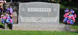
| Birth | : | 16 Mar 1908 Hubbell, Thayer County, Nebraska, USA |
| Death | : | 16 Mar 2000 Osceola, Polk County, Nebraska, USA |
| Burial | : | Morrison Ranch Family Cemetery, Clarksville, El Dorado County, USA |
| Coordinate | : | 38.6552887, -121.0368500 |
| Plot | : | Block 16, Lot 20, Grave 4 |
| Description | : | Thanks to contributor 49091895 STROMSBURG — Lura Ann Clausen, 92, of Stromsburg, died Thursday, March 16, 2000, at Annie Jeffrey Memorial County Health Center in Osceola. Services will be 10 a.m. Monday at the Evangelical Free Church in Stromsburg with the Rev. Kerry Relihan officiating. Burial will be in the Chester Cemetery in Chester at 3 p.m. Monday with the Rev. Ray Berry officiating. Visitation will be from 4 to 7 p.m. Sunday at the Palmer Funeral Home in Stromsburg. Memorials are suggested to the Evangelical Free Church in Stromsburg or Community Bible Church in... Read More |
frequently asked questions (FAQ):
-
Where is Lura Ann Davenport Clausen's memorial?
Lura Ann Davenport Clausen's memorial is located at: Morrison Ranch Family Cemetery, Clarksville, El Dorado County, USA.
-
When did Lura Ann Davenport Clausen death?
Lura Ann Davenport Clausen death on 16 Mar 2000 in Osceola, Polk County, Nebraska, USA
-
Where are the coordinates of the Lura Ann Davenport Clausen's memorial?
Latitude: 38.6552887
Longitude: -121.0368500
Family Members:
Parent
Spouse
Siblings
Children
Flowers:
Nearby Cemetories:
1. Morrison Ranch Family Cemetery
Clarksville, El Dorado County, USA
Coordinate: 38.6552887, -121.0368500
2. Railroad House Cemetery
Clarksville, El Dorado County, USA
Coordinate: 38.6575699, -121.0516129
3. Clarksville Cemetery
Clarksville, El Dorado County, USA
Coordinate: 38.6546707, -121.0615387
4. Rust Family Gravesite
Cameron Park, El Dorado County, USA
Coordinate: 38.6980160, -121.0207130
5. Green Valley Cemetery
Rescue, El Dorado County, USA
Coordinate: 38.6993790, -121.0081406
6. Duroc House Cemetery
Shingle Springs, El Dorado County, USA
Coordinate: 38.6528860, -120.9701690
7. Skinner Ranch Cemetery
Cameron Park, El Dorado County, USA
Coordinate: 38.6981812, -120.9972763
8. Saint Michaels Catholic Cemetery
Cameron Park, El Dorado County, USA
Coordinate: 38.6995010, -120.9985886
9. Mormon Island Relocation Cemetery
El Dorado Hills, El Dorado County, USA
Coordinate: 38.6986084, -121.1093521
10. Litten-McDonald Cemetery
Rescue, El Dorado County, USA
Coordinate: 38.7078750, -120.9628310
11. Planters House Cemetery
Shingle Springs, El Dorado County, USA
Coordinate: 38.6645820, -120.9321300
12. Shingle Springs Cemetery
Shingle Springs, El Dorado County, USA
Coordinate: 38.6648903, -120.9270325
13. Bryant Cemetery
Latrobe, El Dorado County, USA
Coordinate: 38.5830383, -120.9679184
14. Jayhawk Cemetery
Rescue, El Dorado County, USA
Coordinate: 38.7308006, -120.9627991
15. Meyer-Zentgraf Cemetery
Shingle Springs, El Dorado County, USA
Coordinate: 38.6710620, -120.9158490
16. Rose Springs Cemetery
Rescue, El Dorado County, USA
Coordinate: 38.7146150, -120.9398390
17. Heusner Ranch Family Cemetery
Buckeye, El Dorado County, USA
Coordinate: 38.6675770, -120.9135260
18. Frenchtown Cemetery
Frenchtown, El Dorado County, USA
Coordinate: 38.6421585, -120.9132309
19. Latrobe Cemetery
Latrobe, El Dorado County, USA
Coordinate: 38.5613518, -120.9903412
20. Schenck Ranch Cemetery
Frenchtown, El Dorado County, USA
Coordinate: 38.5961120, -120.9281020
21. Folsom Prison Cemetery
Folsom, Sacramento County, USA
Coordinate: 38.6952860, -121.1636690
22. F.O.E. 929 Cemetery
Folsom, Sacramento County, USA
Coordinate: 38.6717010, -121.1801010
23. Saint John the Baptist Catholic Church Cemetery
Folsom, Sacramento County, USA
Coordinate: 38.6721900, -121.1803000
24. Young Wo Cemetery
Folsom, Sacramento County, USA
Coordinate: 38.6733400, -121.1835000


