
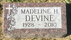
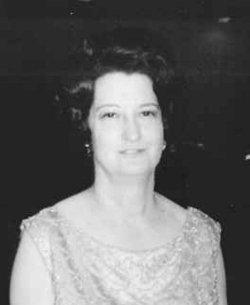
Madeline H. Devine
| Birth | : | 30 Dec 1928 Wakonda, Clay County, South Dakota, USA |
| Death | : | 1 Jul 2010 Sioux Falls, Minnehaha County, South Dakota, USA |
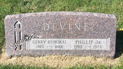
| Burial | : | Blessed Virgin Mary Churchyard, Bruton, South Somerset District, England |
| Coordinate | : | 51.1115790, -2.4520520 |
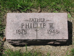
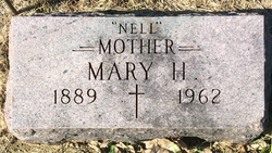
| Description | : | Argus Leader Sioux Falls, S.D. July 2, 2010 Wakonda - Madeline H. Devine, 81, of Sioux Falls, SD passed away Thursday, July 1 at the Dougherty Hospice House in Sioux Falls. Madeline was born December 30, 1928 in Wakonda, SD to Phillip and Nell (Hart) Devine. She grew up on the homestead farm, attended Wakonda Public School and graduated from Mount Marty High School in 1946. She continued her education at Mount Marty College and became an elementary school teacher. Her first teaching assignment was at Ireland country school rural Wakonda. After several years teaching in South Dakota, she was recruited by the... Read More |
frequently asked questions (FAQ):
-
Where is Madeline H. Devine's memorial?
Madeline H. Devine's memorial is located at: Blessed Virgin Mary Churchyard, Bruton, South Somerset District, England.
-
When did Madeline H. Devine death?
Madeline H. Devine death on 1 Jul 2010 in Sioux Falls, Minnehaha County, South Dakota, USA
-
Where are the coordinates of the Madeline H. Devine's memorial?
Latitude: 51.1115790
Longitude: -2.4520520
Family Members:
Parent
Siblings

Flowers:


Nearby Cemetories:
1. Blessed Virgin Mary Churchyard
Bruton, South Somerset District, England
Coordinate: 51.1115790, -2.4520520
2. Bruton Abbey
Bruton, South Somerset District, England
Coordinate: 51.1114890, -2.4530300
3. Bruton Cemetery
Bruton, South Somerset District, England
Coordinate: 51.1208280, -2.4464270
4. St Peter Churchyard
Redlynch, South Somerset District, England
Coordinate: 51.0983279, -2.4299457
5. Church of the Holy Trinity
Bruton, South Somerset District, England
Coordinate: 51.1070450, -2.4843710
6. St Leonard Churchyard and Extension
Pitcombe, South Somerset District, England
Coordinate: 51.0925600, -2.4684600
7. St James Church
Milton Clevedon, Mendip District, England
Coordinate: 51.1381600, -2.4809000
8. Church of St John the Baptist
Brewham, South Somerset District, England
Coordinate: 51.1236330, -2.4017130
9. Saint Mary The Virgin
Batcombe, Mendip District, England
Coordinate: 51.1495900, -2.4433900
10. St. Nicholas' Churchyard
Bratton Seymour, South Somerset District, England
Coordinate: 51.0679406, -2.4625400
11. St Andrew Churchyard
Ansford, South Somerset District, England
Coordinate: 51.0943350, -2.5180470
12. Evercreech Cemetery
Evercreech, Mendip District, England
Coordinate: 51.1461300, -2.4989500
13. St Peter Churchyard
Evercreech, Mendip District, England
Coordinate: 51.1462670, -2.5025440
14. All Saints
Castle Cary, South Somerset District, England
Coordinate: 51.0865760, -2.5165400
15. Saint John's Churchyard
Charlton Musgrove, South Somerset District, England
Coordinate: 51.0840723, -2.3869787
16. Stavordale Priory
Charlton Musgrove, South Somerset District, England
Coordinate: 51.0870410, -2.3778130
17. Castle Cary Cemetery
Castle Cary, South Somerset District, England
Coordinate: 51.0803800, -2.5223600
18. Saint Stephen Churchyard
Charlton Musgrove, South Somerset District, England
Coordinate: 51.0678630, -2.4008550
19. St Mary Magdalene Churchyard
Ditcheat, Mendip District, England
Coordinate: 51.1250270, -2.5362010
20. St Mary's, Chesterblade
Evercreech, Mendip District, England
Coordinate: 51.1692610, -2.4861180
21. The Blessed Virgin Mary Churchyard
Wanstrow, Mendip District, England
Coordinate: 51.1735190, -2.4164890
22. St. Michael Churchyard
Pen Selwood, South Somerset District, England
Coordinate: 51.0816300, -2.3499200
23. Saint Nicholas Churchyard
Holton, South Somerset District, England
Coordinate: 51.0401280, -2.4502641
24. All Saint's Church
Alford, South Somerset District, England
Coordinate: 51.0916210, -2.5659300