
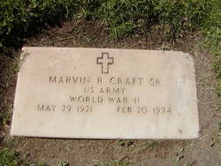

Marvin Richard Craft Sr.
| Birth | : | 29 May 1921 Roseland, Adams County, Nebraska, USA |
| Death | : | 20 Feb 1994 Santa Maria, Santa Barbara County, California, USA |
| Burial | : | Carlton Cemetery, Carlton, Selby District, England |
| Coordinate | : | 53.7129500, -1.0199200 |
| Plot | : | Section 6 East, Lot 159, space 3 |
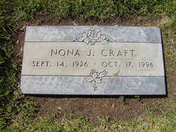
| Description | : | Marvin's 1st marriage Cleo Jeannette Steiger 26 Feb 1923 Grafton, Fillmore, NE, Married 29 Jun 1942 in Grand Island, Hall, NE, (as of 2009 Cleo and Dale Snow her 2nd husband lives in Glenvil, Clay, NE), Marvin and Cleo have 1 son Carl Marvin Craft 26 Sep 1942 Hastings, Adams, NE,(as of 2009 Carl Marvin and Joan (Schmidt) his 3rd wife lives in Giltner, Hamilton, NE) 2nd Marriage Nona Jean Married Marvin Richard (Sr) Craft on 07 Jan 1946 in Smith Center, Smith, KS. They had 5 children 1 son, 4 daughters. 1)Marvin Richard (Jr ) Craft 24 Dec 1946 Hastings, Adams,... Read More |
frequently asked questions (FAQ):
-
Where is Marvin Richard Craft Sr.'s memorial?
Marvin Richard Craft Sr.'s memorial is located at: Carlton Cemetery, Carlton, Selby District, England.
-
When did Marvin Richard Craft Sr. death?
Marvin Richard Craft Sr. death on 20 Feb 1994 in Santa Maria, Santa Barbara County, California, USA
-
Where are the coordinates of the Marvin Richard Craft Sr.'s memorial?
Latitude: 53.7129500
Longitude: -1.0199200
Family Members:
Parent

Spouse
Siblings
Flowers:


Nearby Cemetories:
1. Carlton Cemetery
Carlton, Selby District, England
Coordinate: 53.7129500, -1.0199200
2. St Mary Roman Catholic Church
Carlton, Selby District, England
Coordinate: 53.7111900, -1.0199300
3. St Mary Churchyard
Carlton, Selby District, England
Coordinate: 53.7088060, -1.0209800
4. Drax Cemetery
Drax, Selby District, England
Coordinate: 53.7272540, -0.9875330
5. Holy Trinity Churchyard
East Cowick, East Riding of Yorkshire Unitary Authority, England
Coordinate: 53.6866220, -1.0000200
6. Friends Burial Ground
Drax, Selby District, England
Coordinate: 53.7291640, -0.9771490
7. St Peter and St Paul Churchyard
Drax, Selby District, England
Coordinate: 53.7293790, -0.9771560
8. St. Helen's Churchyard
Barmby on the Marsh, East Riding of Yorkshire Unitary Authority, England
Coordinate: 53.7476490, -0.9549090
9. Barmby on the Marsh Parish Burial Ground
Barmby on the Marsh, East Riding of Yorkshire Unitary Authority, England
Coordinate: 53.7472990, -0.9401910
10. St Mary the Virgin Churchyard
Hemingbrough, Selby District, England
Coordinate: 53.7672100, -0.9796300
11. St John The Baptist Churchyard
Chapel Haddlesey, Selby District, England
Coordinate: 53.7279200, -1.1185700
12. St Paul Churchyard
Hensall, Selby District, England
Coordinate: 53.6967500, -1.1185900
13. St David Churchyard
Airmyn, East Riding of Yorkshire Unitary Authority, England
Coordinate: 53.7178030, -0.9016700
14. Holy Trinity Churchyard
Sykehouse, Metropolitan Borough of Doncaster, England
Coordinate: 53.6449289, -1.0492909
15. St. Wilfrid's Parish Churchyard
Brayton, Selby District, England
Coordinate: 53.7718060, -1.0849010
16. Selby Cemetery
Selby, Selby District, England
Coordinate: 53.7766610, -1.0775960
17. Selby Abbey
Selby, Selby District, England
Coordinate: 53.7840990, -1.0670270
18. All Saints Churchyard
Barlby, Selby District, England
Coordinate: 53.7987840, -1.0415840
19. St. John the Evangelist Churchyard
Goole, East Riding of Yorkshire Unitary Authority, England
Coordinate: 53.7024600, -0.8719260
20. St. Edmund's Churchyard
Kellington, Selby District, England
Coordinate: 53.7142600, -1.1710500
21. Howden Cemetery
Howden, East Riding of Yorkshire Unitary Authority, England
Coordinate: 53.7438890, -0.8770090
22. St. Wilfrith's Churchyard
Moorends, Metropolitan Borough of Doncaster, England
Coordinate: 53.6306940, -0.9502050
23. Catholic Church of The Sacred Heart
Howden, East Riding of Yorkshire Unitary Authority, England
Coordinate: 53.7428360, -0.8709800
24. Howden Minster Churchyard
Howden, East Riding of Yorkshire Unitary Authority, England
Coordinate: 53.7449550, -0.8670300