
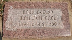
Mary Evelyn Hooper Wohlschlegel Davis
| Birth | : | 11 Oct 1898 Trenton, Grundy County, Missouri, USA |
| Death | : | 13 Apr 1980 Harper, Harper County, Kansas, USA |
| Burial | : | Our Lady of Czestochowa Cemetery, Montague, Franklin County, USA |
| Coordinate | : | 42.5846000, -72.5469400 |
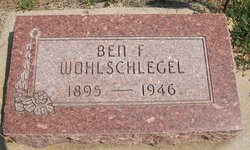
| Description | : | On May 1, 1919 Mary Evelyn Hooper, age 20, married Ben F. Wohlschlegel, age 23, in Lamar, Prowers County, Colorado, United States. Citation: "Colorado Statewide Marriage Index, 1853-2006," database with images, FamilySearch (https://familysearch.org/pal:/MM9.1.1/KNQY-FWN : 8 December 2017), Ben F Wohlschlegel and Mary Evelyn Hooper, 01 May 1919, Lamar, Prowers, Colorado, United States; citing no. 1927, State Archives, Denver; FHL microfilm 1,690,150. Contributor: Teresa Richey Obituary: Mary E. Wohlschlegel Davis passed away Sunday, April 13 1980 at Harper Hospital in Harper, Kansas. She was born on October 11, 1898 in Trenton, Missouri, the daughter of... Read More |
frequently asked questions (FAQ):
-
Where is Mary Evelyn Hooper Wohlschlegel Davis's memorial?
Mary Evelyn Hooper Wohlschlegel Davis's memorial is located at: Our Lady of Czestochowa Cemetery, Montague, Franklin County, USA.
-
When did Mary Evelyn Hooper Wohlschlegel Davis death?
Mary Evelyn Hooper Wohlschlegel Davis death on 13 Apr 1980 in Harper, Harper County, Kansas, USA
-
Where are the coordinates of the Mary Evelyn Hooper Wohlschlegel Davis's memorial?
Latitude: 42.5846000
Longitude: -72.5469400
Family Members:
Parent
Spouse
Siblings

Children
Flowers:


Nearby Cemetories:
1. Our Lady of Czestochowa Cemetery
Montague, Franklin County, USA
Coordinate: 42.5846000, -72.5469400
2. Saint Marys Cemetery
Montague, Franklin County, USA
Coordinate: 42.5852200, -72.5475100
3. Aaron Clark Memorial Cemetery
Montague, Franklin County, USA
Coordinate: 42.5836200, -72.5471600
4. Saint Annes Cemetery
Montague, Franklin County, USA
Coordinate: 42.5861300, -72.5480600
5. Springdale Cemetery
Montague, Franklin County, USA
Coordinate: 42.5884700, -72.5530900
6. Fairway Avenue Cemetery
Montague, Franklin County, USA
Coordinate: 42.5924270, -72.5646970
7. Burnham Cemetery
Montague, Franklin County, USA
Coordinate: 42.5875300, -72.5720140
8. East Mineral Road Cemetery
Montague, Franklin County, USA
Coordinate: 42.5810500, -72.5086300
9. Highland Cemetery
Montague, Franklin County, USA
Coordinate: 42.5778008, -72.5083008
10. Riverside Cemetery
Gill, Franklin County, USA
Coordinate: 42.6156006, -72.5410995
11. East Deerfield Cemetery
Deerfield, Franklin County, USA
Coordinate: 42.5555992, -72.5642014
12. High Street Cemetery
Greenfield, Franklin County, USA
Coordinate: 42.6044840, -72.5806660
13. Federal Street Cemetery
Greenfield, Franklin County, USA
Coordinate: 42.5941400, -72.5977300
14. Town Cemetery
Montague, Franklin County, USA
Coordinate: 42.5595000, -72.5070200
15. Green River Cemetery
Greenfield, Franklin County, USA
Coordinate: 42.5804400, -72.6052500
16. Elm Grove Cemetery
Montague, Franklin County, USA
Coordinate: 42.5418600, -72.5359000
17. Old Catholic Cemetery
Greenfield, Franklin County, USA
Coordinate: 42.5795753, -72.6064215
18. Locust Hill Cemetery
Montague, Franklin County, USA
Coordinate: 42.5394700, -72.5363400
19. Calvary Cemetery
Greenfield, Franklin County, USA
Coordinate: 42.5764008, -72.6138992
20. Durkee Burial Lot
Northfield, Franklin County, USA
Coordinate: 42.6070000, -72.4861000
21. Mater Dolorosa Cemetery
Greenfield, Franklin County, USA
Coordinate: 42.5758000, -72.6165000
22. Lower Meadow Cemetery
Greenfield, Franklin County, USA
Coordinate: 42.5945600, -72.6200300
23. Log Plain Cemetery
Greenfield, Franklin County, USA
Coordinate: 42.6378320, -72.5725800
24. Laurel Hill Cemetery
Deerfield, Franklin County, USA
Coordinate: 42.5416670, -72.5973020