Mary Magdalene Morgan Efird
| Birth | : | 25 May 1923 Oakboro, Stanly County, North Carolina, USA |
| Death | : | 28 Dec 1994 Charlotte, Mecklenburg County, North Carolina, USA |
| Burial | : | Mount Olivet Cemetery, Stet, Carroll County, USA |
| Coordinate | : | 39.4366000, -93.7403000 |
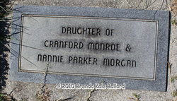
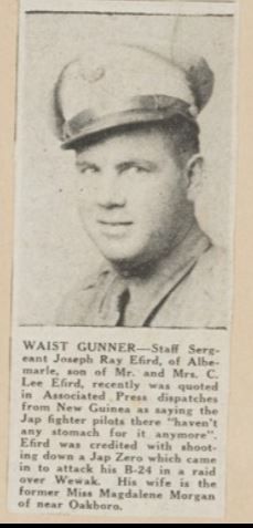
| Description | : | Mrs. Mary Magdalene Morgan Efird 71, homemaker, died Dec. 28, 1994, at Carolinas Medical Center in Charlotte. Funeral is 2 p.m. today at St. Martin's Lutheran Church. Survivors are her sons, Alyre Efird of Charlotte, Nalan Efird of Hickory; brother, Robert Morgan of Oakboro; sister, Ms. Addie Lee Honeycutt of Locust. Stanly Funeral Home is in charge. Memorials may be made to St. Martin's Lutheran Church, 16524 St. Martin's Church Rd., Albemarle, NC 28001. Obituary published in The Charlotte Observer on Dec. 30, 1994. Daughter of Cranford Monroe Morgan & Nannie Parker. |
frequently asked questions (FAQ):
-
Where is Mary Magdalene Morgan Efird's memorial?
Mary Magdalene Morgan Efird's memorial is located at: Mount Olivet Cemetery, Stet, Carroll County, USA.
-
When did Mary Magdalene Morgan Efird death?
Mary Magdalene Morgan Efird death on 28 Dec 1994 in Charlotte, Mecklenburg County, North Carolina, USA
-
Where are the coordinates of the Mary Magdalene Morgan Efird's memorial?
Latitude: 39.4366000
Longitude: -93.7403000
Family Members:
Parent
Spouse
Siblings
Flowers:
Nearby Cemetories:
1. Tevalt-Northern Sympathizers Cemetery
Carroll County, USA
Coordinate: 39.4593010, -93.7379990
2. Union Baptist Church Cemetery
Roads, Carroll County, USA
Coordinate: 39.4486008, -93.7021027
3. Bethany Church Cemetery
Stet, Ray County, USA
Coordinate: 39.4230995, -93.7838974
4. Antioch Cemetery
Norborne, Carroll County, USA
Coordinate: 39.4083519, -93.7010498
5. Silas Keith Cemetery
Regal, Ray County, USA
Coordinate: 39.4387800, -93.8262100
6. Graff Cemetery
Grape Grove Township, Ray County, USA
Coordinate: 39.4909286, -93.8144836
7. New Hope United Methodist Church Cemetery
Millville, Ray County, USA
Coordinate: 39.4236259, -93.8416061
8. Old New Hope Cemetery
Millville, Ray County, USA
Coordinate: 39.4327200, -93.8435900
9. Elder Cemetery
Grape Grove Township, Ray County, USA
Coordinate: 39.5015259, -93.8108826
10. Tinney Grove Cemetery
Tinney Grove, Ray County, USA
Coordinate: 39.5066280, -93.8050000
11. Providence Cemetery
Norborne, Carroll County, USA
Coordinate: 39.3511009, -93.7230988
12. McBee Chapel Cemetery
Carroll County, USA
Coordinate: 39.5239983, -93.7559967
13. McCuistion Cemetery
Richmond, Ray County, USA
Coordinate: 39.4387300, -93.8550900
14. Hawkins Cemetery
Carroll County, USA
Coordinate: 39.5014000, -93.6569977
15. Meinking-Wilson Cemetery
Ray County, USA
Coordinate: 39.3576200, -93.7995600
16. Low Gap Cemetery
Norborne, Carroll County, USA
Coordinate: 39.5244000, -93.7024000
17. Woolard Cemetery
Hardin, Ray County, USA
Coordinate: 39.3769300, -93.8351500
18. Clark Cemetery
Hardin, Ray County, USA
Coordinate: 39.3499985, -93.7956009
19. Unnamed Cemetery #47
Carroll County, USA
Coordinate: 39.3558998, -93.6673965
20. Smith Cemetery
Carroll County, USA
Coordinate: 39.4813995, -93.6205978
21. Liberty Cemetery
Hardin, Ray County, USA
Coordinate: 39.3331800, -93.7667800
22. McCroskie Creek Baptist Church Cemetery
Carroll County, USA
Coordinate: 39.3840179, -93.6199951
23. Carleton Cemetery
Ray County, USA
Coordinate: 39.4014200, -93.8712700
24. Mansur Cemetery
Grape Grove Township, Ray County, USA
Coordinate: 39.4230003, -93.8804016


