

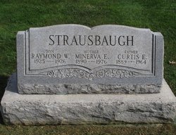
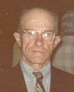
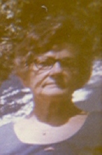
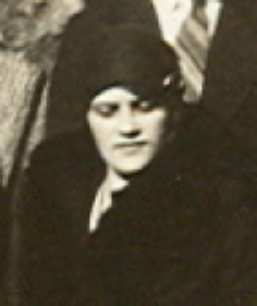
Minerva Edna Wagner Strausbaugh
| Birth | : | 9 Jun 1890 |
| Death | : | 12 Jan 1976 |
| Burial | : | St Andrew Churchyard, Kelby, North Kesteven District, England |
| Coordinate | : | 52.9608000, -0.5074000 |
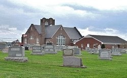
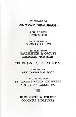
| Description | : | _________________________________________ STRAUSBAUGH - On January 12, 1976, at 7:30 a.m., at her residence, 442 E. Walnut St., Minerva E. Strausbaugh, widow of Curtis E. Strausbaugh, aged 85 years, 7 months, 3 days. Relatives and friends are invited to attend the funeral services Thursday, at 2 p.m., at the Baumeister and Orcutt Colonial Mortuary, South Queen and Jackson Streets. Interment in St. Jacob's Cemetery, York New Salem. Relatives and friends are invited to call at the mortuary Wednesday evening from 7 to 9. York Daily Record, Wednesday January 14, 1976 Mrs. Minerva E. Strausbaugh Mrs. Minerva E. Strausbaugh, 85, widow of Curtis Strausbaugh, formerly of York... Read More |
frequently asked questions (FAQ):
-
Where is Minerva Edna Wagner Strausbaugh's memorial?
Minerva Edna Wagner Strausbaugh's memorial is located at: St Andrew Churchyard, Kelby, North Kesteven District, England.
-
When did Minerva Edna Wagner Strausbaugh death?
Minerva Edna Wagner Strausbaugh death on 12 Jan 1976 in
-
Where are the coordinates of the Minerva Edna Wagner Strausbaugh's memorial?
Latitude: 52.9608000
Longitude: -0.5074000
Family Members:
Parent
Spouse
Siblings
Children

Flowers:


Nearby Cemetories:
1. St Andrew Churchyard
Kelby, North Kesteven District, England
Coordinate: 52.9608000, -0.5074000
2. St. Andrew's Churchyard
South Kesteven District, England
Coordinate: 52.9608000, -0.5074000
3. St. Mary's Churchyard
Wilsford, North Kesteven District, England
Coordinate: 52.9751600, -0.5023700
4. St. Michael's and All Angels Churchyard
Heydour, South Kesteven District, England
Coordinate: 52.9444900, -0.4987800
5. Saint Michael Churchyard
Heydour, South Kesteven District, England
Coordinate: 52.9443700, -0.4987000
6. St. Martin Churchyard
Ancaster, South Kesteven District, England
Coordinate: 52.9804810, -0.5377820
7. Ancaster Cemetery
Ancaster, South Kesteven District, England
Coordinate: 52.9814450, -0.5387892
8. Rauceby Hospital Cemetery
Quarrington, North Kesteven District, England
Coordinate: 52.9807077, -0.4549731
9. St Thomas Churchyard
Aunsby, North Kesteven District, England
Coordinate: 52.9367820, -0.4470450
10. St Peter's Churchyard
North Rauceby, North Kesteven District, England
Coordinate: 53.0056400, -0.4796500
11. St. Lucia Churchyard
Dembleby, North Kesteven District, England
Coordinate: 52.9268000, -0.4512300
12. St. Denis Churchyard
Silk Willoughby, North Kesteven District, England
Coordinate: 52.9738460, -0.4268830
13. St Denys Churchyard
Silk Willoughby, North Kesteven District, England
Coordinate: 52.9736976, -0.4263297
14. St Botolph Churchyard
Quarrington, North Kesteven District, England
Coordinate: 52.9872010, -0.4312350
15. St John the Baptist Churchyard
Londonthorpe, South Kesteven District, England
Coordinate: 52.9312060, -0.5837350
16. St. Wilfrid Churchyard
Honington, South Kesteven District, England
Coordinate: 52.9795600, -0.5965700
17. St. Nicholas Churchyard
Carlton Scroop, South Kesteven District, England
Coordinate: 52.9940290, -0.5895960
18. St Nicholas Churchyard
Barkston, South Kesteven District, England
Coordinate: 52.9629960, -0.6129380
19. St Nicholas Churchyard
Normanton, South Kesteven District, England
Coordinate: 53.0051390, -0.5874570
20. St. Peter's Churchyard
Ropsley, South Kesteven District, England
Coordinate: 52.8959736, -0.5259958
21. Ropsley Churchyard Extension
Ropsley, South Kesteven District, England
Coordinate: 52.8958475, -0.5254147
22. St Peter & St Paul Churchyard
Osbournby, North Kesteven District, England
Coordinate: 52.9298800, -0.4105100
23. St Marys Churchyard
Syston, South Kesteven District, England
Coordinate: 52.9578420, -0.6172940
24. St. Peter and St. Paul's Churchyard
Belton, South Kesteven District, England
Coordinate: 52.9451000, -0.6177000