


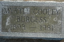
Myrtle Cooley Burgess
| Birth | : | 16 Jul 1893 Clinton, Clinton County, Iowa, USA |
| Death | : | 1981 Clinton, Clinton County, Iowa, USA |
| Burial | : | St. Andrew's Churchyard, Cheddar, Sedgemoor District, England |
| Coordinate | : | 51.2736740, -2.7761330 |
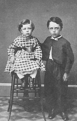
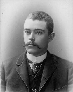
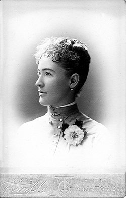
| Description | : | Myrtle Cooley was born July 16,1893 in clinton Iowa to parents, Ward W. Cooley and Bertha Hobein Cooley of Clinton, IA. W. W. Cooley was married July 27, 1886. There were four children born to this mariage: Wendell W. Cooley, March 12, 1887; Albert Cooley March 22, 1889 - December 21, 1902; Myrtle Cooley, born July 16, 1893, and Viola Cooley, born September 4, 1901. Myrtle was married to Homer Burgess of Spring Valley, Illinois They were seperated not long after their marriage |
frequently asked questions (FAQ):
-
Where is Myrtle Cooley Burgess's memorial?
Myrtle Cooley Burgess's memorial is located at: St. Andrew's Churchyard, Cheddar, Sedgemoor District, England.
-
When did Myrtle Cooley Burgess death?
Myrtle Cooley Burgess death on 1981 in Clinton, Clinton County, Iowa, USA
-
Where are the coordinates of the Myrtle Cooley Burgess's memorial?
Latitude: 51.2736740
Longitude: -2.7761330
Family Members:
Parent
Siblings


Flowers:


Nearby Cemetories:
1. St. Andrew's Churchyard
Cheddar, Sedgemoor District, England
Coordinate: 51.2736740, -2.7761330
2. Cheddar Baptist Burial Ground
Cheddar, Sedgemoor District, England
Coordinate: 51.2767330, -2.7792010
3. St. Peter's Churchyard
Draycott, Mendip District, England
Coordinate: 51.2580900, -2.7523800
4. St. Michael Sanatorium Cemetery
Axbridge, Sedgemoor District, England
Coordinate: 51.2904100, -2.8056900
5. St. John the Baptist Churchyard
Axbridge, Sedgemoor District, England
Coordinate: 51.2876300, -2.8162900
6. St. Leonard's Churchyard
Rodney Stoke, Mendip District, England
Coordinate: 51.2455140, -2.7431800
7. St Gregory Churchyard
Weare, Sedgemoor District, England
Coordinate: 51.2699900, -2.8408600
8. St Leonard's Churchyard
Shipham, Sedgemoor District, England
Coordinate: 51.3130980, -2.8001830
9. St. Mary Magdalene Churchyard Extension
Wedmore, Sedgemoor District, England
Coordinate: 51.2327583, -2.8065246
10. Shipham Cemetery
Shipham, Sedgemoor District, England
Coordinate: 51.3201930, -2.7992390
11. St. Mary Churchyard
Wedmore, Sedgemoor District, England
Coordinate: 51.2276790, -2.8110360
12. St Michael and All Angels
Rowberrow, North Somerset Unitary Authority, England
Coordinate: 51.3240000, -2.7915000
13. Allerton Churchyard
Chapel Allerton, Sedgemoor District, England
Coordinate: 51.2479860, -2.8482400
14. Baptist Churchyard
Wedmore, Sedgemoor District, England
Coordinate: 51.2260400, -2.8099800
15. St Lawrence Churchyard
Westbury, Mendip District, England
Coordinate: 51.2354140, -2.7182630
16. St. James the Great Churchyard
Winscombe, North Somerset Unitary Authority, England
Coordinate: 51.3059750, -2.8456900
17. St Congar Churchyard
Badgworth, Sedgemoor District, England
Coordinate: 51.2699300, -2.8674000
18. Holy Trinity Churchyard
Burrington, North Somerset Unitary Authority, England
Coordinate: 51.3307830, -2.7496010
19. Saint Andrew Churchyard
Compton Bishop, Sedgemoor District, England
Coordinate: 51.2943290, -2.8678900
20. Winscombe and Sandford Cemetery
Winscombe, North Somerset Unitary Authority, England
Coordinate: 51.3223861, -2.8386889
21. Methodist Church Burial Ground
Churchill, North Somerset Unitary Authority, England
Coordinate: 51.3344140, -2.8000610
22. Christ Church Theale
Wedmore, Sedgemoor District, England
Coordinate: 51.2113720, -2.7631570
23. St. Lawrence's Churchyard
Priddy, Mendip District, England
Coordinate: 51.2596770, -2.6777600
24. Holy Trinity Churchyard
Blackford, Sedgemoor District, England
Coordinate: 51.2257800, -2.8483000