
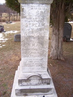
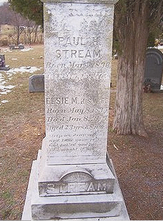
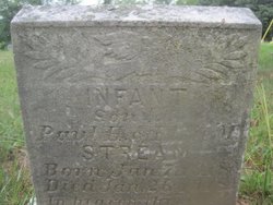
Paul Henry Stream
| Birth | : | 4 Mar 1890 Loudoun County, Virginia, USA |
| Death | : | 18 May 1973 Taylorstown, Loudoun County, Virginia, USA |
| Burial | : | Preston New Cemetery, Ribbleton, City of Preston, England |
| Coordinate | : | 53.7717400, -2.6620900 |
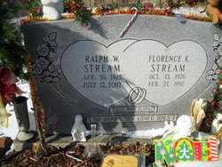
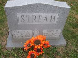
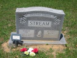
| Description | : | Paul Henry Stream was married to Elsie Myrtle Loy on 20 Jul 1915 He was the son of John Henery Stream and Nannie Gerturude Wenner. They had two children Emory Lee Stream and a Boy that died young, Later he married Sarah Catherine Taylor and the had the following children, Tom Henry, Ralph William, Paul Luther, John David, Mable Marie, Martha Irene, Robert Lee, Ruth Virginia, George Melvin, Elizabeth Gertrude, Mary Louise, Katherine Evelyn, Adrian Martin Stream |
frequently asked questions (FAQ):
-
Where is Paul Henry Stream's memorial?
Paul Henry Stream's memorial is located at: Preston New Cemetery, Ribbleton, City of Preston, England.
-
When did Paul Henry Stream death?
Paul Henry Stream death on 18 May 1973 in Taylorstown, Loudoun County, Virginia, USA
-
Where are the coordinates of the Paul Henry Stream's memorial?
Latitude: 53.7717400
Longitude: -2.6620900
Family Members:
Parent

Spouse
Siblings
Children

Flowers:


Nearby Cemetories:
1. Preston New Cemetery
Ribbleton, City of Preston, England
Coordinate: 53.7717400, -2.6620900
2. Preston Old Cemetery
Ribbleton, City of Preston, England
Coordinate: 53.7686352, -2.6623154
3. St. Paul Churchyard
Preston, City of Preston, England
Coordinate: 53.7625360, -2.6947080
4. St. Ignatius RC Churchyard
Preston, City of Preston, England
Coordinate: 53.7635270, -2.6965870
5. Preston Crematorium
Preston, City of Preston, England
Coordinate: 53.7863750, -2.6340170
6. St. Leonard the Less Churchyard
Samlesbury, South Ribble Borough, England
Coordinate: 53.7680000, -2.6237000
7. St Augustine of Canterbury
Preston, City of Preston, England
Coordinate: 53.7560420, -2.6912650
8. St John Churchyard
Preston, City of Preston, England
Coordinate: 53.7582080, -2.6959750
9. St. James' Churchyard
Preston, City of Preston, England
Coordinate: 53.7566010, -2.6941110
10. St Leonard Churchyard
Walton-le-Dale, South Ribble Borough, England
Coordinate: 53.7476530, -2.6666950
11. Christ Church Churchyard
Fulwood, City of Preston, England
Coordinate: 53.7771920, -2.7028700
12. St. Mary's and St. John RC Churchyard, Southworth
Samlesbury, South Ribble Borough, England
Coordinate: 53.7676690, -2.6183400
13. Holy Trinity
Preston, City of Preston, England
Coordinate: 53.7613030, -2.7030580
14. Friends Meeting House Burial Ground (Defunct)
Preston, City of Preston, England
Coordinate: 53.7610250, -2.7030380
15. St. George the Martyr
Preston, City of Preston, England
Coordinate: 53.7591220, -2.7025660
16. Saint Peter Churchyard
Preston, City of Preston, England
Coordinate: 53.7634100, -2.7080700
17. St. Wilfrid's Catholic Cemetery
Preston, City of Preston, England
Coordinate: 53.7581670, -2.7044930
18. Grey Friars' Church
Preston, City of Preston, England
Coordinate: 53.7601480, -2.7084600
19. St. Mary's Churchyard
Preston, City of Preston, England
Coordinate: 53.8010830, -2.6779600
20. St. Michael's Churchyard
Grimsargh, City of Preston, England
Coordinate: 53.7990710, -2.6352530
21. Christ Church Churchyard
Preston, City of Preston, England
Coordinate: 53.7573210, -2.7103080
22. St Walburge's RC Church
Preston, City of Preston, England
Coordinate: 53.7629690, -2.7149620
23. All Saints Churchyard
Walton-le-Dale, South Ribble Borough, England
Coordinate: 53.7407250, -2.6408280
24. Our Lady and St Patrick's Church
Walton-le-Dale, South Ribble Borough, England
Coordinate: 53.7407250, -2.6408280