
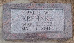
Paul Walter Krehnke
| Birth | : | 3 Mar 1903 Pierce, Pierce County, Nebraska, USA |
| Death | : | 5 Mar 2000 Norfolk, Madison County, Nebraska, USA |
| Burial | : | All Saints Churchyard, Helmsley, Ryedale District, England |
| Coordinate | : | 54.2469000, -1.0625000 |
frequently asked questions (FAQ):
-
Where is Paul Walter Krehnke's memorial?
Paul Walter Krehnke's memorial is located at: All Saints Churchyard, Helmsley, Ryedale District, England.
-
When did Paul Walter Krehnke death?
Paul Walter Krehnke death on 5 Mar 2000 in Norfolk, Madison County, Nebraska, USA
-
Where are the coordinates of the Paul Walter Krehnke's memorial?
Latitude: 54.2469000
Longitude: -1.0625000
Family Members:
Parent

Siblings

Flowers:


Nearby Cemetories:
1. All Saints Churchyard
Helmsley, Ryedale District, England
Coordinate: 54.2469000, -1.0625000
2. Helmsley Town Cemetery
Helmsley, Ryedale District, England
Coordinate: 54.2483300, -1.0620300
3. Rievaulx Abbey
Helmsley, Ryedale District, England
Coordinate: 54.2449170, -1.0639570
4. Harome Village Cemetery
Harome, Ryedale District, England
Coordinate: 54.2308650, -1.0096380
5. St Saviour Churchyard
Harome, Ryedale District, England
Coordinate: 54.2302000, -1.0088000
6. St Oswald Churchyard
Oswaldkirk, Ryedale District, England
Coordinate: 54.2022340, -1.0495510
7. Ampleforth Abbey - Monk's Wood
Ampleforth, Ryedale District, England
Coordinate: 54.2028689, -1.0841344
8. Ampleforth Abbey
Ampleforth, Ryedale District, England
Coordinate: 54.2019630, -1.0838000
9. Our Lady & St Benedict RC Churchyard
Ampleforth, Ryedale District, England
Coordinate: 54.2009700, -1.1055400
10. St Hilda Churchyard
Ampleforth, Ryedale District, England
Coordinate: 54.2000630, -1.1075590
11. Ampleforth Friends Burial Ground
Ampleforth, Ryedale District, England
Coordinate: 54.2023420, -1.1213330
12. Saint Mary’s Churchyard
Scawton, Ryedale District, England
Coordinate: 54.2451000, -1.1591000
13. All Saints Churchyard
Old Byland, Ryedale District, England
Coordinate: 54.2663000, -1.1558000
14. St Gregory Minster Churchyard Extension
Nawton, Ryedale District, England
Coordinate: 54.2628100, -0.9629100
15. St. Gregory's Minster Churchyard
Kirkdale, Ryedale District, England
Coordinate: 54.2628300, -0.9622613
16. St Gregory Minster Churchyard
Nawton, Ryedale District, England
Coordinate: 54.2627570, -0.9621910
17. Gilling New Churchyard
Gilling East, Ryedale District, England
Coordinate: 54.1856070, -1.0559535
18. Holy Cross Churchyard
Gilling East, Ryedale District, England
Coordinate: 54.1841290, -1.0580460
19. All Saints and St James Church
Nunnington, Ryedale District, England
Coordinate: 54.2031000, -0.9806000
20. Stonegrave Minster Churchyard
Stonegrave, Ryedale District, England
Coordinate: 54.1925011, -0.9966000
21. St Michael Churchyard
Cold Kirby, Ryedale District, England
Coordinate: 54.2534580, -1.1827120
22. Byland Abbey
Coxwold, Hambleton District, England
Coordinate: 54.2034480, -1.1589660
23. All Saints Churchyard
Kirkbymoorside, Ryedale District, England
Coordinate: 54.2703470, -0.9310110
24. St. Michael and All Angels Churchyard
Edstone, Ryedale District, England
Coordinate: 54.2469000, -0.9188000