

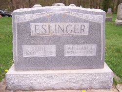
Sadie Pirtle Eslinger
| Birth | : | 17 Dec 1880 Sullivan County, Indiana, USA |
| Death | : | 19 Sep 1958 Sullivan, Sullivan County, Indiana, USA |
| Burial | : | Preston Old Cemetery, Ribbleton, City of Preston, England |
| Coordinate | : | 53.7686352, -2.6623154 |
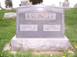
| Description | : | Married to Homer Bruce Eslinger on November 17, 1900. Mother of William L. Eslinger. OBITUARY: Mrs. Sadie Eslinger Sullivan, Ind. Sept. 20 -- (Special) Mrs. Sadie Eslinger, 78 years old, died early Friday morning at the residence. She was a member of the Sullivan Methodist Church. Surviving are a son, William of Sullivan, and a half sister, Mrs. Dorothy Newsom of Gary. The body was taken to the Carrithers Funeral Home where friends may call after 6 o'clock Saturday afternoon. Funeral services will be at 2 o'clock Monday afternoon at the funeral home. The... Read More |
frequently asked questions (FAQ):
-
Where is Sadie Pirtle Eslinger's memorial?
Sadie Pirtle Eslinger's memorial is located at: Preston Old Cemetery, Ribbleton, City of Preston, England.
-
When did Sadie Pirtle Eslinger death?
Sadie Pirtle Eslinger death on 19 Sep 1958 in Sullivan, Sullivan County, Indiana, USA
-
Where are the coordinates of the Sadie Pirtle Eslinger's memorial?
Latitude: 53.7686352
Longitude: -2.6623154
Family Members:
Spouse
Children
Flowers:


Nearby Cemetories:
1. Preston Old Cemetery
Ribbleton, City of Preston, England
Coordinate: 53.7686352, -2.6623154
2. Preston New Cemetery
Ribbleton, City of Preston, England
Coordinate: 53.7717400, -2.6620900
3. St. Paul Churchyard
Preston, City of Preston, England
Coordinate: 53.7625360, -2.6947080
4. St. Ignatius RC Churchyard
Preston, City of Preston, England
Coordinate: 53.7635270, -2.6965870
5. St Leonard Churchyard
Walton-le-Dale, South Ribble Borough, England
Coordinate: 53.7476530, -2.6666950
6. St Augustine of Canterbury
Preston, City of Preston, England
Coordinate: 53.7560420, -2.6912650
7. St. James' Churchyard
Preston, City of Preston, England
Coordinate: 53.7566010, -2.6941110
8. St John Churchyard
Preston, City of Preston, England
Coordinate: 53.7582080, -2.6959750
9. St. Leonard the Less Churchyard
Samlesbury, South Ribble Borough, England
Coordinate: 53.7680000, -2.6237000
10. Preston Crematorium
Preston, City of Preston, England
Coordinate: 53.7863750, -2.6340170
11. Holy Trinity
Preston, City of Preston, England
Coordinate: 53.7613030, -2.7030580
12. Friends Meeting House Burial Ground (Defunct)
Preston, City of Preston, England
Coordinate: 53.7610250, -2.7030380
13. Christ Church Churchyard
Fulwood, City of Preston, England
Coordinate: 53.7771920, -2.7028700
14. St. George the Martyr
Preston, City of Preston, England
Coordinate: 53.7591220, -2.7025660
15. St. Mary's and St. John RC Churchyard, Southworth
Samlesbury, South Ribble Borough, England
Coordinate: 53.7676690, -2.6183400
16. St. Wilfrid's Catholic Cemetery
Preston, City of Preston, England
Coordinate: 53.7581670, -2.7044930
17. Saint Peter Churchyard
Preston, City of Preston, England
Coordinate: 53.7634100, -2.7080700
18. Grey Friars' Church
Preston, City of Preston, England
Coordinate: 53.7601480, -2.7084600
19. Christ Church Churchyard
Preston, City of Preston, England
Coordinate: 53.7573210, -2.7103080
20. All Saints Churchyard
Walton-le-Dale, South Ribble Borough, England
Coordinate: 53.7407250, -2.6408280
21. Our Lady and St Patrick's Church
Walton-le-Dale, South Ribble Borough, England
Coordinate: 53.7407250, -2.6408280
22. St Walburge's RC Church
Preston, City of Preston, England
Coordinate: 53.7629690, -2.7149620
23. St. Mary's Churchyard
Preston, City of Preston, England
Coordinate: 53.8010830, -2.6779600
24. St. Michael's Churchyard
Grimsargh, City of Preston, England
Coordinate: 53.7990710, -2.6352530