
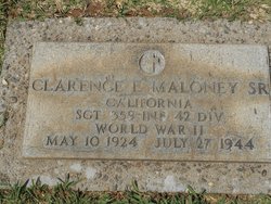
Sgt Clarence Elbert Maloney
| Birth | : | 10 May 1924 California, USA |
| Death | : | 27 Jul 1944 France |
| Burial | : | Lincoln Cemetery, Lincoln, Placer County, USA |
| Coordinate | : | 38.8864310, -121.3020500 |
| Inscription | : | "California - SGT - 359 INF 42 DIV - World War II" |
| Description | : | Clarence was the husband of Doris nee Parscale, father of Clarence Jr., and brother to four sisters and two brothers. Clarence attended Lincoln High School for two years and enlisted in the US Army on August 17, 1943, in Sacramento. The following May he was sent overseas where he was wounded on a battlefield in France and died of his wounds the next day. In a letter home that was received a few days before his death, Sgt. Maloney said the "going was tough," but also added, "we are having lots of fun." On October 5, 1948, his remains were... Read More |
frequently asked questions (FAQ):
-
Where is Sgt Clarence Elbert Maloney's memorial?
Sgt Clarence Elbert Maloney's memorial is located at: Lincoln Cemetery, Lincoln, Placer County, USA.
-
When did Sgt Clarence Elbert Maloney death?
Sgt Clarence Elbert Maloney death on 27 Jul 1944 in France
-
Where are the coordinates of the Sgt Clarence Elbert Maloney's memorial?
Latitude: 38.8864310
Longitude: -121.3020500
Family Members:
Parent
Siblings


Nearby Cemetories:
1. Lincoln Cemetery
Lincoln, Placer County, USA
Coordinate: 38.8864310, -121.3020500
2. Santa Clara Memorial Park
Lincoln, Placer County, USA
Coordinate: 38.8894710, -121.3260560
3. Manzanita Cemetery
Lincoln, Placer County, USA
Coordinate: 38.9444008, -121.3032990
4. Whitney Family Mausoleum
Rocklin, Placer County, USA
Coordinate: 38.8256500, -121.2477000
5. Morgan Oaks Eternal Preserve
Lincoln, Placer County, USA
Coordinate: 38.9629050, -121.2860530
6. Gold Hill Cemetery
Gold Hill, Placer County, USA
Coordinate: 38.9025000, -121.1802200
7. Sheridan Cemetery
Sheridan, Placer County, USA
Coordinate: 38.9741000, -121.3585300
8. School House Park Cemetery
Roseville, Placer County, USA
Coordinate: 38.7893180, -121.3578670
9. Rocklin Cemetery
Rocklin, Placer County, USA
Coordinate: 38.7827670, -121.2337980
10. Newcastle Cemetery
Newcastle, Placer County, USA
Coordinate: 38.8708880, -121.1444060
11. Stewarts Flat Cemetery
Penryn, Placer County, USA
Coordinate: 38.8447360, -121.1507950
12. Roseville Public Cemetery District
Roseville, Placer County, USA
Coordinate: 38.7606010, -121.2707977
13. Shepherd of the Sierra Memorial Garden
Loomis, Placer County, USA
Coordinate: 38.7890800, -121.1944200
14. Boothill Cemetery
Roseville, Placer County, USA
Coordinate: 38.7598730, -121.2712130
15. Ophir Cemetery
Placer County, USA
Coordinate: 38.8928870, -121.1273790
16. Lone Star Cemetery
Placer County, USA
Coordinate: 38.9757996, -121.1380997
17. Camp Far West Cemetery
Wheatland, Yuba County, USA
Coordinate: 39.0395500, -121.3431400
18. Prosser Family Cemetery
Loomis, Placer County, USA
Coordinate: 38.8071900, -121.1285600
19. Mansur Family Cemetery
Loomis, Placer County, USA
Coordinate: 38.8139600, -121.1214000
20. Wheatland Cemetery
Wheatland, Yuba County, USA
Coordinate: 39.0083008, -121.4360962
21. New Auburn Cemetery
Auburn, Placer County, USA
Coordinate: 38.9026900, -121.0870800
22. Union Cemetery
Roseville, Placer County, USA
Coordinate: 38.7302600, -121.3924200
23. Old Auburn Cemetery
Auburn, Placer County, USA
Coordinate: 38.9023720, -121.0812230
24. Wells Cemetery
Auburn, Placer County, USA
Coordinate: 38.9667000, -121.1054900