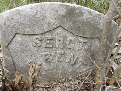
Sgt William Preston Bentley
| Birth | : | 9 May 1838 Rushville, Rush County, Indiana, USA |
| Death | : | 29 Apr 1921 Maryville, Nodaway County, Missouri, USA |
| Burial | : | St. Nicholas Churchyard, Ash, Dover District, England |
| Coordinate | : | 51.2786800, 1.2786400 |
| Inscription | : | Sergt Co H 51st Mo Inf |
| Description | : | Veteran of the Civil War 82y 11n 20d. Husband of Susan J. Brittain, married 10 Oct 1861 Nodaway Co., MO. Father of two: Frank and ? Bentley. Son of Levi and Mary (Cain) Bentley. Brother of Ely H Bentley. MO Death Cert #10175 Price Funeral Home. After the death of his parents William and Eli lived with their maternal grandparents, Jesse and Mariam Cain. They remained close to their grandparents, aunts, uncles and extended family. Both William and Eli are buried near their Cain relatives. |
frequently asked questions (FAQ):
-
Where is Sgt William Preston Bentley's memorial?
Sgt William Preston Bentley's memorial is located at: St. Nicholas Churchyard, Ash, Dover District, England.
-
When did Sgt William Preston Bentley death?
Sgt William Preston Bentley death on 29 Apr 1921 in Maryville, Nodaway County, Missouri, USA
-
Where are the coordinates of the Sgt William Preston Bentley's memorial?
Latitude: 51.2786800
Longitude: 1.2786400
Family Members:
Spouse
Children
Nearby Cemetories:
1. St. Nicholas Churchyard
Ash, Dover District, England
Coordinate: 51.2786800, 1.2786400
2. St James the Great Churchyard
Staple, Dover District, England
Coordinate: 51.2636300, 1.2515200
3. Saint Mary The Virgin Churchyard
Woodnesborough, Dover District, England
Coordinate: 51.2628240, 1.3073810
4. Elmstone Churchyard
Preston, Dover District, England
Coordinate: 51.2967160, 1.2424980
5. St .Mary's Churchyard
Sandwich, Dover District, England
Coordinate: 51.2771930, 1.3386580
6. St Mary the Virgin Churchyard
Eastry, Dover District, England
Coordinate: 51.2453000, 1.3100000
7. St. Peter's Churchyard
Sandwich, Dover District, England
Coordinate: 51.2747680, 1.3405120
8. St Clement's Church
Sandwich, Dover District, England
Coordinate: 51.2736510, 1.3427270
9. St Mary the Virgin Churchyard
Wingham, Dover District, England
Coordinate: 51.2721220, 1.2128950
10. St Mildred Churchyard
Preston, Dover District, England
Coordinate: 51.2985000, 1.2173980
11. St Clement Church
Knowlton, Dover District, England
Coordinate: 51.2348930, 1.2652130
12. Holy Cross
Goodnestone, Dover District, England
Coordinate: 51.2457190, 1.2290550
13. Church of Saint George at Ham
Eastry, Dover District, England
Coordinate: 51.2444830, 1.3319350
14. All Saints Churchyard
Stourmouth, Dover District, England
Coordinate: 51.3202600, 1.2365520
15. St Mary the Virgin Church
Minster-in-Thanet, Thanet District, England
Coordinate: 51.3305810, 1.3156720
16. St Mary the Virgin Churchyard
Betteshanger, Dover District, England
Coordinate: 51.2251200, 1.3118800
17. St Andrew Churchyard
Wickhambreaux, City of Canterbury, England
Coordinate: 51.2844400, 1.1822300
18. St Mary the Virgin Churchyard
Nonington, Dover District, England
Coordinate: 51.2258300, 1.2253800
19. Stodmarsh St Marys Churchyard
Wickhambreaux, City of Canterbury, England
Coordinate: 51.3009500, 1.1836900
20. Saint Andrew Churchyard
Tilmanstone, Dover District, England
Coordinate: 51.2159790, 1.2950400
21. Holy Innocents Churchyard
Adisham, City of Canterbury, England
Coordinate: 51.2440380, 1.1903320
22. Minster Cemetery
Minster-in-Thanet, Thanet District, England
Coordinate: 51.3423100, 1.3160550
23. St Augustine Churchyard
Northbourne, Dover District, England
Coordinate: 51.2221700, 1.3403500
24. St Nicholas’ Barfrestone Church Burial Ground
Eythorne, Dover District, England
Coordinate: 51.2056350, 1.2400870


