| Birth | : | 10 Apr 1950 North Platte, Lincoln County, Nebraska, USA |
| Death | : | 11 Apr 1950 North Platte, Lincoln County, Nebraska, USA |
| Burial | : | Monk Fryston Cemetery, Monk Fryston, Selby District, England |
| Coordinate | : | 53.7604400, -1.2291700 |
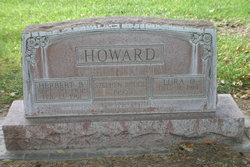
| Description | : | Buried April 12, 1950 Lot 983 Section E Space-01A Stephen Bruce Howard April 10, 1950-April 11,1950 Howard Infant Dies Today Stephen Howard, infant son of Mrs and Mrs Herbert Howard, 709 East 10th, died early this morning within 24 hours after birth. Graveside services will be held at 2:30 p.m. Wednesday in North Platte Cemetery, with the Rev. Seward H. Bean, Pastor Episcopal Church of our Savior officiating. Surviving the infant in addition to his parents are a brother, Herbert Melvin, 3, a half brother, Robert; Grandfather, George W. Howard, North Platte; and a Grandmother, Mrs Myrtle... Read More |
frequently asked questions (FAQ):
-
Where is Stephen Bruce Howard's memorial?
Stephen Bruce Howard's memorial is located at: Monk Fryston Cemetery, Monk Fryston, Selby District, England.
-
When did Stephen Bruce Howard death?
Stephen Bruce Howard death on 11 Apr 1950 in North Platte, Lincoln County, Nebraska, USA
-
Where are the coordinates of the Stephen Bruce Howard's memorial?
Latitude: 53.7604400
Longitude: -1.2291700
Family Members:
Parent
Siblings
Flowers:
Nearby Cemetories:
1. Monk Fryston Cemetery
Monk Fryston, Selby District, England
Coordinate: 53.7604400, -1.2291700
2. St Wilfrid’s Churchyard
Monk Fryston, Selby District, England
Coordinate: 53.7618300, -1.2349700
3. St Mary the Virgin Churchyard
South Milford, Selby District, England
Coordinate: 53.7771700, -1.2547300
4. St Mary Churchyard
Birkin, Selby District, England
Coordinate: 53.7325000, -1.1979000
5. St James Churchyard
Fairburn, Selby District, England
Coordinate: 53.7426700, -1.2841000
6. All Saints Churchyard
Sherburn-in-Elmet, Selby District, England
Coordinate: 53.7956000, -1.2605740
7. Brotherton United Reformed Church
Brotherton, Selby District, England
Coordinate: 53.7277104, -1.2698131
8. Hambleton Cemetery
Hambleton, Selby District, England
Coordinate: 53.7715910, -1.1624600
9. St Mary Churchyard
Hambleton, Selby District, England
Coordinate: 53.7715910, -1.1624600
10. St Edward the Confessor Churchyard
Brotherton, Selby District, England
Coordinate: 53.7259200, -1.2709600
11. All Saints Churchyard
Ledsham, Metropolitan Borough of Leeds, England
Coordinate: 53.7622160, -1.3091920
12. St. Andrew's Old Churchyard
Ferrybridge, Metropolitan Borough of Wakefield, England
Coordinate: 53.7193380, -1.2748540
13. United Reformed Churchyard
Knottingley, Metropolitan Borough of Wakefield, England
Coordinate: 53.7104820, -1.2397270
14. St. Botolph Churchyard
Knottingley, Metropolitan Borough of Wakefield, England
Coordinate: 53.7108080, -1.2441680
15. Ropewalk Methodist Church Burial Ground
Knottingley, Metropolitan Borough of Wakefield, England
Coordinate: 53.7092850, -1.2408320
16. St. Peter's Churchyard
Fryston, Metropolitan Borough of Wakefield, England
Coordinate: 53.7355400, -1.3151100
17. St. Edmund's Churchyard
Kellington, Selby District, England
Coordinate: 53.7142600, -1.1710500
18. Ferrybridge Cemetery
Ferrybridge, Metropolitan Borough of Wakefield, England
Coordinate: 53.7102530, -1.2795200
19. Knottingley Cemetery
Knottingley, Metropolitan Borough of Wakefield, England
Coordinate: 53.7018600, -1.2363390
20. Holy Trinity Churchyard
Barkston Ash, Selby District, England
Coordinate: 53.8189530, -1.2547620
21. St Mary the Virgin Churchyard
Church Fenton, Selby District, England
Coordinate: 53.8243100, -1.2203500
22. St. Mary the Virgin Churchyard
Micklefield, Metropolitan Borough of Leeds, England
Coordinate: 53.7971300, -1.3313700
23. All Saints Churchyard
Saxton, Selby District, England
Coordinate: 53.8261760, -1.2787060
24. Castleford New Extension Cemetery
Castleford, Metropolitan Borough of Wakefield, England
Coordinate: 53.7277600, -1.3391000


