
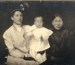
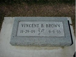
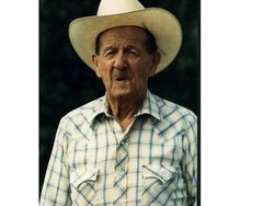
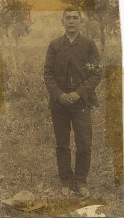
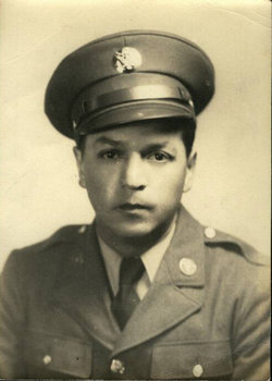
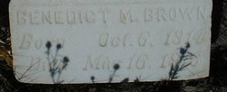
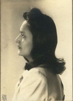
Vincent Bernard Brown
| Birth | : | 29 Nov 1909 Browning, Glacier County, Montana, USA |
| Death | : | 9 Sep 1993 Browning, Glacier County, Montana, USA |
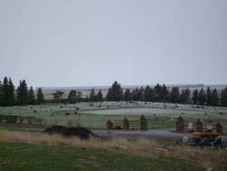
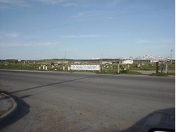
| Burial | : | St. Andrew's Churchyard, Backwell, North Somerset Unitary Authority, England |
| Coordinate | : | 51.4118600, -2.7297400 |
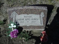
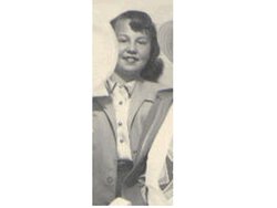
| Description | : | Not much is known about Uncle Vincent. He was a carpenter by Trade. He was married to Evelyn "Evy" Mott for years and years and they had five children together. They divorced. In later years he became partners with Myrtle Running Wolf and they were together until he died. |
frequently asked questions (FAQ):
-
Where is Vincent Bernard Brown's memorial?
Vincent Bernard Brown's memorial is located at: St. Andrew's Churchyard, Backwell, North Somerset Unitary Authority, England.
-
When did Vincent Bernard Brown death?
Vincent Bernard Brown death on 9 Sep 1993 in Browning, Glacier County, Montana, USA
-
Where are the coordinates of the Vincent Bernard Brown's memorial?
Latitude: 51.4118600
Longitude: -2.7297400
Family Members:
Parent
Spouse
Siblings


Children
Flowers:


Nearby Cemetories:
1. St. Andrew's Churchyard
Backwell, North Somerset Unitary Authority, England
Coordinate: 51.4118600, -2.7297400
2. St Michael & All Angels
Flax Bourton, North Somerset Unitary Authority, England
Coordinate: 51.4212620, -2.7109840
3. Ss Mary and Edward Churchyard
Barrow Gurney, North Somerset Unitary Authority, England
Coordinate: 51.4130630, -2.6989510
4. Saint Bridget's Churchyard
Chelvey, North Somerset Unitary Authority, England
Coordinate: 51.4117570, -2.7689680
5. St. Nicholas' Churchyard
Brockley, North Somerset Unitary Authority, England
Coordinate: 51.3988950, -2.7686830
6. Holy Trinity Churchyard
Nailsea, North Somerset Unitary Authority, England
Coordinate: 51.4258140, -2.7692830
7. Christ Church Churchyard
Nailsea, North Somerset Unitary Authority, England
Coordinate: 51.4336490, -2.7612050
8. Nailsea Garden of Rest
Nailsea, North Somerset Unitary Authority, England
Coordinate: 51.4340540, -2.7613880
9. Tyntesfield House Chapel
Wraxall, North Somerset Unitary Authority, England
Coordinate: 51.4407400, -2.7110500
10. St Katharine and The Noble Army Churchyard
Felton, North Somerset Unitary Authority, England
Coordinate: 51.3876440, -2.6979950
11. All Saints Churchyard
Wraxall, North Somerset Unitary Authority, England
Coordinate: 51.4444000, -2.7348000
12. Holy Trinity Churchyard
Cleeve, North Somerset Unitary Authority, England
Coordinate: 51.3908200, -2.7773600
13. Ss Quiricus & Julietta Churchyard
Tickenham, North Somerset Unitary Authority, England
Coordinate: 51.4394000, -2.7814000
14. Christ Church Churchyard
Redhill, North Somerset Unitary Authority, England
Coordinate: 51.3657790, -2.7245240
15. St. Bartholomew's Churchyard
Failand, North Somerset Unitary Authority, England
Coordinate: 51.4584000, -2.7000000
16. Wrington Chapel
Wrington, North Somerset Unitary Authority, England
Coordinate: 51.3651900, -2.7638270
17. Saint Michael Churchyard
Clapton-in-Gordano, North Somerset Unitary Authority, England
Coordinate: 51.4583000, -2.7673000
18. Church of St. Mary and St. Peter
Winford, North Somerset Unitary Authority, England
Coordinate: 51.3820870, -2.6580510
19. All Saints Churchyard
Wrington, North Somerset Unitary Authority, England
Coordinate: 51.3610710, -2.7657110
20. All Saints Churchyard
Long Ashton, North Somerset Unitary Authority, England
Coordinate: 51.4358100, -2.6439400
21. St. Michael Churchyard
Dundry, North Somerset Unitary Authority, England
Coordinate: 51.3990510, -2.6374330
22. St. Michael and All Angels Churchyard
Butcombe, North Somerset Unitary Authority, England
Coordinate: 51.3538470, -2.6973670
23. St. Mary's Churchyard
Yatton, North Somerset Unitary Authority, England
Coordinate: 51.3847720, -2.8185510
24. Yatton Parish Council Burial Grounds
Yatton, North Somerset Unitary Authority, England
Coordinate: 51.3840541, -2.8182519