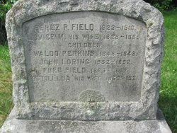
Waldo Perkins Field
| Birth | : | 30 Oct 1848 Stoughton, Norfolk County, Massachusetts, USA |
| Death | : | 31 Aug 1849 Stoughton, Norfolk County, Massachusetts, USA |
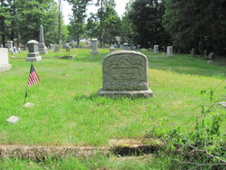
| Burial | : | St Nicholas Churchyard, Piddington, Cherwell District, England |
| Coordinate | : | 51.8477520, -1.0723950 |
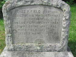
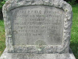
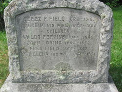
| Description | : | Birth record of Oct. 30, 1848 in Stoughton, Mass. lists name as Waldo Perez, son of Perez P. (Bootmaker) & Lovice M. Field. Gravestone says Waldo Perkins. |
frequently asked questions (FAQ):
-
Where is Waldo Perkins Field's memorial?
Waldo Perkins Field's memorial is located at: St Nicholas Churchyard, Piddington, Cherwell District, England.
-
When did Waldo Perkins Field death?
Waldo Perkins Field death on 31 Aug 1849 in Stoughton, Norfolk County, Massachusetts, USA
-
Where are the coordinates of the Waldo Perkins Field's memorial?
Latitude: 51.8477520
Longitude: -1.0723950
Family Members:
Parent
Siblings
Flowers:
Nearby Cemetories:
1. St Nicholas Churchyard
Piddington, Cherwell District, England
Coordinate: 51.8477520, -1.0723950
2. St John the Baptist Churchyard
Piddington, Cherwell District, England
Coordinate: 51.8477859, -1.0723360
3. St. Mary the Virgin Churchyard
Ludgershall, Aylesbury Vale District, England
Coordinate: 51.8495250, -1.0434220
4. St. James' Churchyard
Boarstall, Aylesbury Vale District, England
Coordinate: 51.8218170, -1.0926460
5. All Saints Churchyard
Brill, Aylesbury Vale District, England
Coordinate: 51.8196440, -1.0490570
6. St Marys Churchyard
Ambrosden, Cherwell District, England
Coordinate: 51.8699990, -1.1255190
7. St Mary Churchyard
Oakley, Aylesbury Vale District, England
Coordinate: 51.8054770, -1.0704700
8. St John the Baptist
Dorton, Aylesbury Vale District, England
Coordinate: 51.8198434, -1.0162377
9. St Leonard Churchyard
Grendon Underwood, Aylesbury Vale District, England
Coordinate: 51.8832800, -1.0174800
10. Marsh Gibbon Cemetery
Bicester, Cherwell District, England
Coordinate: 51.9000250, -1.0607810
11. St Mary the Virgin Churchyard
Marsh Gibbon, Aylesbury Vale District, England
Coordinate: 51.9038310, -1.0601060
12. Bethel Congregational Church
Launton, Cherwell District, England
Coordinate: 51.8979200, -1.1151020
13. St Swithuns Churchyard
Merton, Cherwell District, England
Coordinate: 51.8559670, -1.1633060
14. Studley Priory
Horton-cum-Studley, Cherwell District, England
Coordinate: 51.8054560, -1.1346920
15. St Barnabas Churchyard
Horton-cum-Studley, Cherwell District, England
Coordinate: 51.8077260, -1.1409690
16. St Marys Churchyard
Launton, Cherwell District, England
Coordinate: 51.9006740, -1.1230300
17. St Michael and All Angels Churchyard
Edgcott, Aylesbury Vale District, England
Coordinate: 51.8995450, -1.0132210
18. St Marys Churchyard
Ashendon, Aylesbury Vale District, England
Coordinate: 51.8221320, -0.9784380
19. St. Mary's Churchyard
Chilton, Aylesbury Vale District, England
Coordinate: 51.7988760, -1.0055490
20. Independent Chapel Cemetery
Bicester, Cherwell District, England
Coordinate: 51.8960550, -1.1514940
21. St Marys Churchyard
Westcott, Aylesbury Vale District, England
Coordinate: 51.8482790, -0.9609600
22. St Mary Church Cemetery
Charlton-on-Otmoor, Cherwell District, England
Coordinate: 51.8394100, -1.1838090
23. Bicester Town Cemetery
Bicester, Cherwell District, England
Coordinate: 51.8945880, -1.1553730
24. St Edburg Churchyard
Bicester, Cherwell District, England
Coordinate: 51.8960060, -1.1541930

