
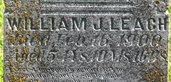
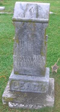
William J. Leach
| Birth | : | 22 Apr 1845 Delaware County, Indiana, USA |
| Death | : | 16 Feb 1900 Monona County, Iowa, USA |
| Burial | : | St Peter and St Paul Churchyard, Lingfield, Tandridge District, England |
| Coordinate | : | 51.1763840, -0.0142480 |
| Plot | : | Block 7, Lot 52 |
| Inscription | : | Aged 54 Years, 10 Months, 16 Days |
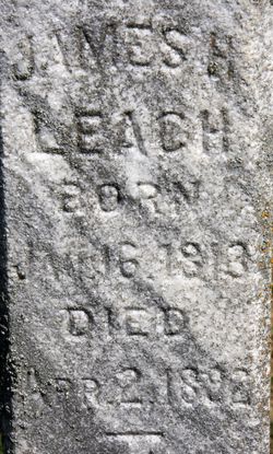
| Description | : | CIVIL WAR VETERAN ~ 149 INDIANA INFANTRY, CO. E. ~ ------------------------- William J. Leach Birth: 22 APR 1845 in Indiana Father: James H. Leach b: 16 JAN 1813 in Ruch County, Indiana Mother: Mary M. Wilson b: 14 AUG 1814 in Butler County, Ohio ---------------------------- Marriage 1 Diana Ball, b: 1856 in Iowa- ----------------------------------------- Diana's marriage history: 1. 1875 Diana Ball married 1st to William J Leach 18 Apr 1875 in Monona County, Iowa, USA Memorial# 60653826 2. 1905 Diana Ball Leach married 2nd to George Horace Smith 15 Oct 1905 in Mapleton, Monona, Iowa, USA 3. 1907 ... Read More |
frequently asked questions (FAQ):
-
Where is William J. Leach's memorial?
William J. Leach's memorial is located at: St Peter and St Paul Churchyard, Lingfield, Tandridge District, England.
-
When did William J. Leach death?
William J. Leach death on 16 Feb 1900 in Monona County, Iowa, USA
-
Where are the coordinates of the William J. Leach's memorial?
Latitude: 51.1763840
Longitude: -0.0142480
Family Members:
Parent
Spouse

Siblings
Flowers:


Nearby Cemetories:
1. St Peter and St Paul Churchyard
Lingfield, Tandridge District, England
Coordinate: 51.1763840, -0.0142480
2. Dormansland Baptist Chapelyard
Dormansland, Tandridge District, England
Coordinate: 51.1634300, 0.0073300
3. St John the Evangelist Churchyard
Dormansland, Tandridge District, England
Coordinate: 51.1597320, 0.0054300
4. St. John the Evangelist Churchyard
Blindley Heath, Tandridge District, England
Coordinate: 51.1961510, -0.0536070
5. St John The Divine
Felbridge, Tandridge District, England
Coordinate: 51.1414480, -0.0392460
6. Mount Noddy Cemetery
East Grinstead, Mid Sussex District, England
Coordinate: 51.1316231, -0.0066281
7. St. Mary the Virgin Churchyard
Horne, Tandridge District, England
Coordinate: 51.1827330, -0.0886630
8. St. Swithun's Churchyard
East Grinstead, Mid Sussex District, England
Coordinate: 51.1240380, -0.0058020
9. St. Lawrence's Catholic Churchyard
Edenbridge, Sevenoaks District, England
Coordinate: 51.1951354, 0.0654156
10. St Peter and St Paul Churchyard
Edenbridge, Sevenoaks District, England
Coordinate: 51.1959000, 0.0661400
11. Edenbridge Cemetery
Edenbridge, Sevenoaks District, England
Coordinate: 51.1962400, 0.0680000
12. Smallfield Ebenezer Chapel Cemetery
Smallfield, Tandridge District, England
Coordinate: 51.1770230, -0.1151960
13. St John the Baptist Churchyard
Outwood, Tandridge District, England
Coordinate: 51.1981770, -0.1127510
14. St Peter Churchyard
Tandridge, Tandridge District, England
Coordinate: 51.2429480, -0.0320950
15. All Saints Churchyard
Crawley Down, Mid Sussex District, England
Coordinate: 51.1211200, -0.0830650
16. St Bartholomew Churchyard
Burstow, Tandridge District, England
Coordinate: 51.1558610, -0.1247750
17. St. Peter's Churchyard
Holtye, Wealden District, England
Coordinate: 51.1338783, 0.0821108
18. St John the Evangelist Churchyard
Copthorne, Crawley Borough, England
Coordinate: 51.1394100, -0.1175700
19. Saint Nicholas Churchyard
Godstone, Tandridge District, England
Coordinate: 51.2465740, -0.0567650
20. Cowden New Burial Ground
Cowden, Sevenoaks District, England
Coordinate: 51.1447210, 0.0958650
21. Holy Trinity Churchyard
Markbeech, Sevenoaks District, England
Coordinate: 51.1651750, 0.1077720
22. Hever Castle Grounds
Hever, Sevenoaks District, England
Coordinate: 51.1843770, 0.1111220
23. St Peter Churchyard
Hever, Sevenoaks District, England
Coordinate: 51.1838050, 0.1112430
24. Bletchingley Cemetery
Bletchingley, Tandridge District, England
Coordinate: 51.2411080, -0.0911120