
| Memorials | : | 1 |
| Location | : | Gloucester, City of Gloucester, England |
| Coordinate | : | 51.8693000, -2.2291000 |
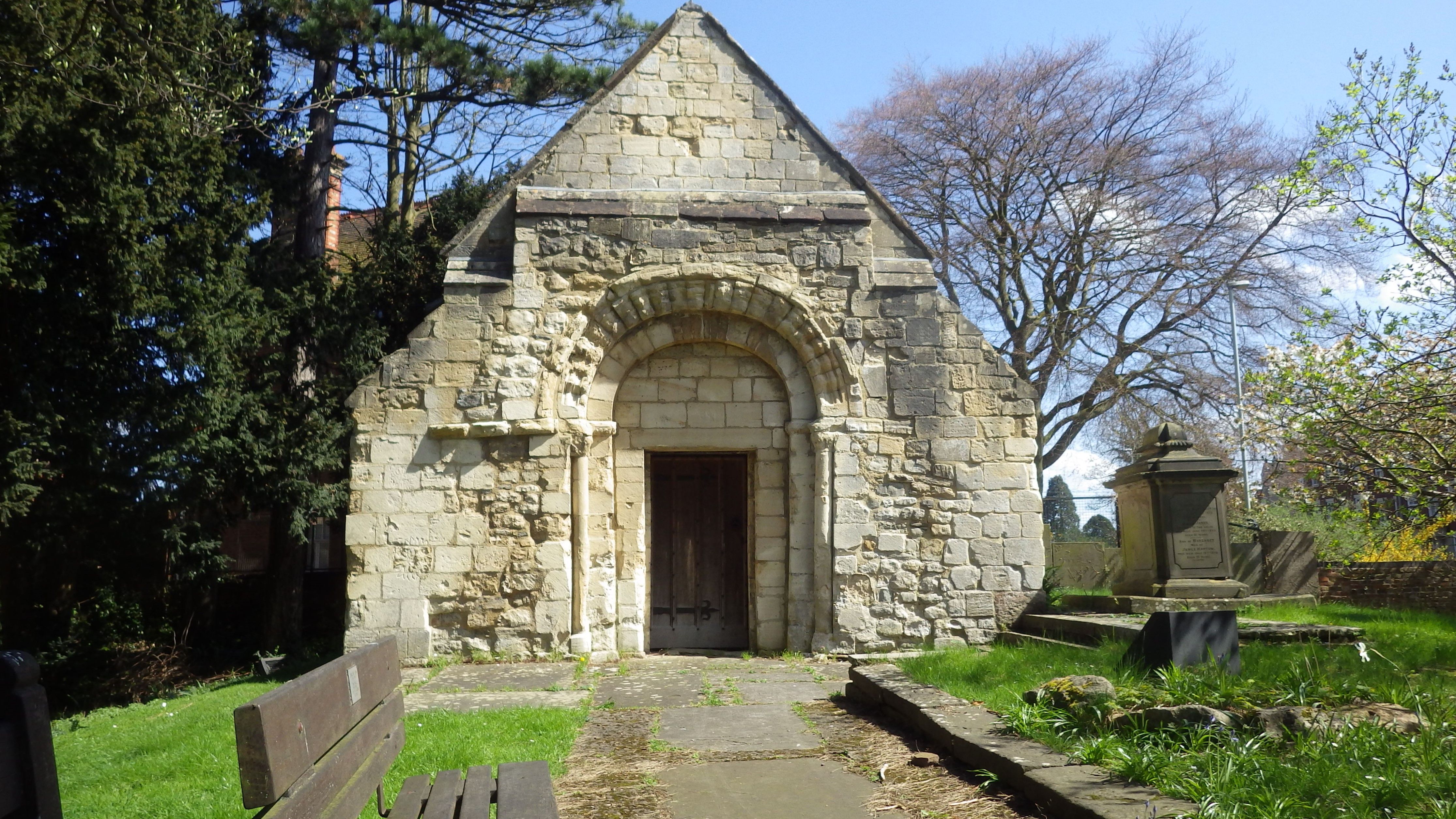
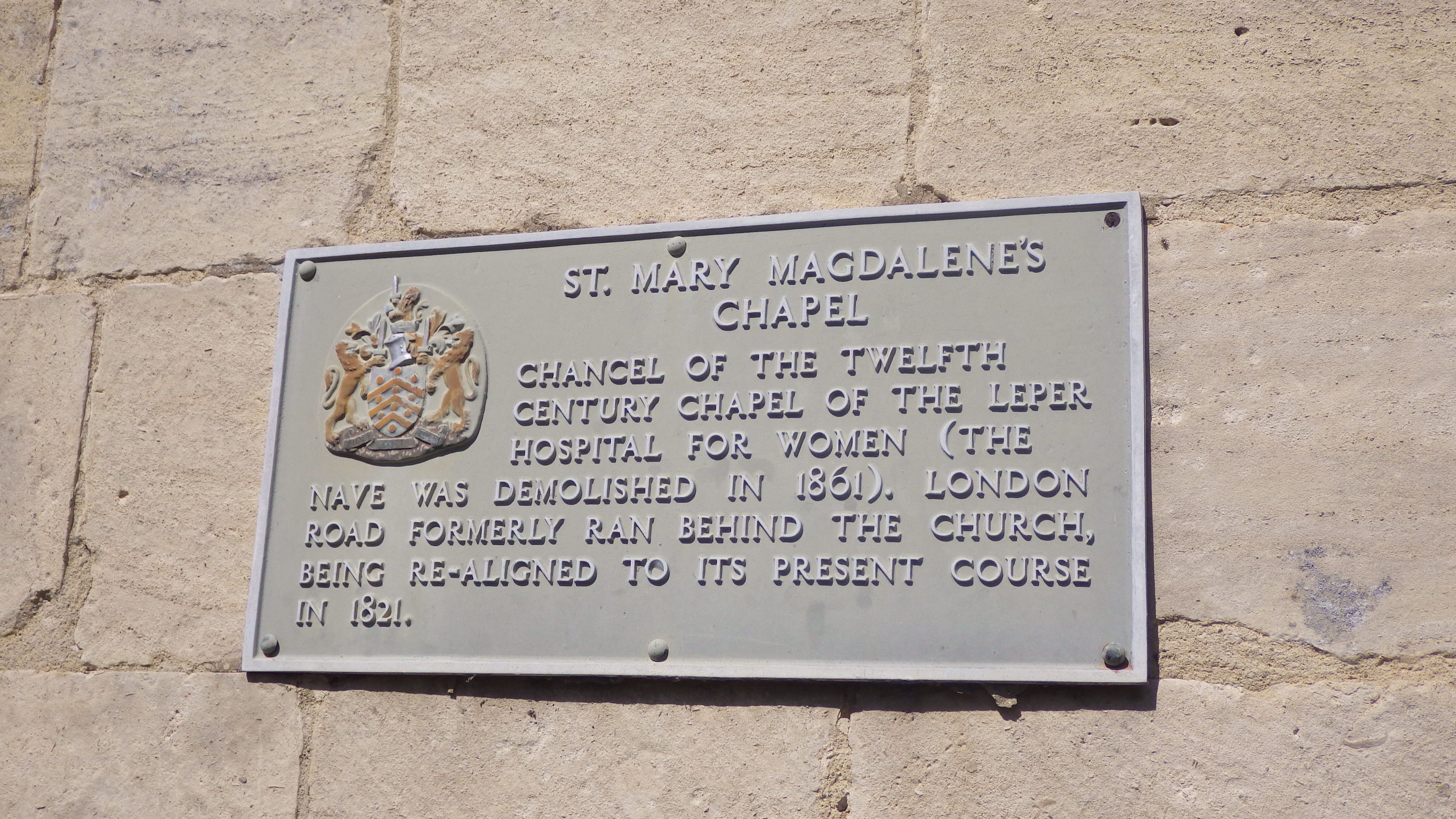
| Description | : | The chapel was built in the 1st half of the 12th century to serve the inmates of the hospital of St Mary Magdalene. By the 1830s both hospital and chapel had fallen into disrepair, and in 1861 the hospital, and the nave of the chapel were demolished by the City Council. The south doorway was retained and reset in the infilled chancel arch, now the west wall of the chapel. Outside few gravestones remain, none in their original location. A small number are concreted in place along the east boundary. A few are used as paths. These are mostly completely... Read More |
frequently asked questions (FAQ):
-
Where is Chapel of St Mary Magdalen?
Chapel of St Mary Magdalen is located at London Road, Wotton, Gloucester. Within Hillfield Gardens. Gloucester, City of Gloucester ,Gloucestershire , GL1 3 CDEngland.
-
Chapel of St Mary Magdalen cemetery's updated grave count on graveviews.com?
1 memorials
-
Where are the coordinates of the Chapel of St Mary Magdalen?
Latitude: 51.8693000
Longitude: -2.2291000
Nearby Cemetories:
1. Saint Catharine's
Gloucester, City of Gloucester, England
Coordinate: 51.8691700, -2.2273500
2. St Margaret's Chapel
Gloucester, City of Gloucester, England
Coordinate: 51.8686720, -2.2321530
3. Horton Road Cemetery
Gloucester, City of Gloucester, England
Coordinate: 51.8666900, -2.2268300
4. Gloucester Cathedral
Gloucester, City of Gloucester, England
Coordinate: 51.8675920, -2.2467670
5. Saint Oswald's Priory
Gloucester, City of Gloucester, England
Coordinate: 51.8694000, -2.2478000
6. St Nicholas' Church
Gloucester, City of Gloucester, England
Coordinate: 51.8672800, -2.2496760
7. Gloucester Crematorium
Gloucester, City of Gloucester, England
Coordinate: 51.8538180, -2.2219260
8. St Lawrence Churchyard
Barnwood, City of Gloucester, England
Coordinate: 51.8580470, -2.2069750
9. Llanthony Secunda Priory
Hempsted, City of Gloucester, England
Coordinate: 51.8602130, -2.2572640
10. Gloucester Old Cemetery
Gloucester, City of Gloucester, England
Coordinate: 51.8482100, -2.2276700
11. St. Matthew's Cemetery
Twigworth, Tewkesbury Borough, England
Coordinate: 51.8936090, -2.2307820
12. Ss Philip and James Churchyard
Hucclecote, Tewkesbury Borough, England
Coordinate: 51.8573040, -2.1876440
13. St. Swithun's Churchyard
Hempsted, City of Gloucester, England
Coordinate: 51.8515740, -2.2719420
14. St. Giles Churchyard
Maisemore, Tewkesbury Borough, England
Coordinate: 51.8931690, -2.2719540
15. St Lawrence Churchyard
Sandhurst, Tewkesbury Borough, England
Coordinate: 51.9083260, -2.2489570
16. Holy Innocents Churchyard
Highnam, Tewkesbury Borough, England
Coordinate: 51.8740890, -2.2970050
17. St George Churchyard
Brockworth, Tewkesbury Borough, England
Coordinate: 51.8517460, -2.1598180
18. St. Oswald Churchyard
Lassington, Tewkesbury Borough, England
Coordinate: 51.8884700, -2.2978000
19. St Margaret Church
Whaddon, Stroud District, England
Coordinate: 51.8214600, -2.2433000
20. Holy Trinity Churchyard
Badgeworth, Tewkesbury Borough, England
Coordinate: 51.8715360, -2.1444640
21. St. James' Churchyard
Quedgeley, City of Gloucester, England
Coordinate: 51.8257770, -2.2811150
22. Prinknash Abbey
Cranham, Stroud District, England
Coordinate: 51.8225000, -2.1761110
23. St. Swithun Churchyard
Brookthorpe, Stroud District, England
Coordinate: 51.8087500, -2.2402900
24. St. Mary the Virgin Cemetery
Rudford, Forest of Dean District, England
Coordinate: 51.8936272, -2.3213976