
| Memorials | : | 1 |
| Location | : | Gloucester, City of Gloucester, England |
| Coordinate | : | 51.8694000, -2.2478000 |
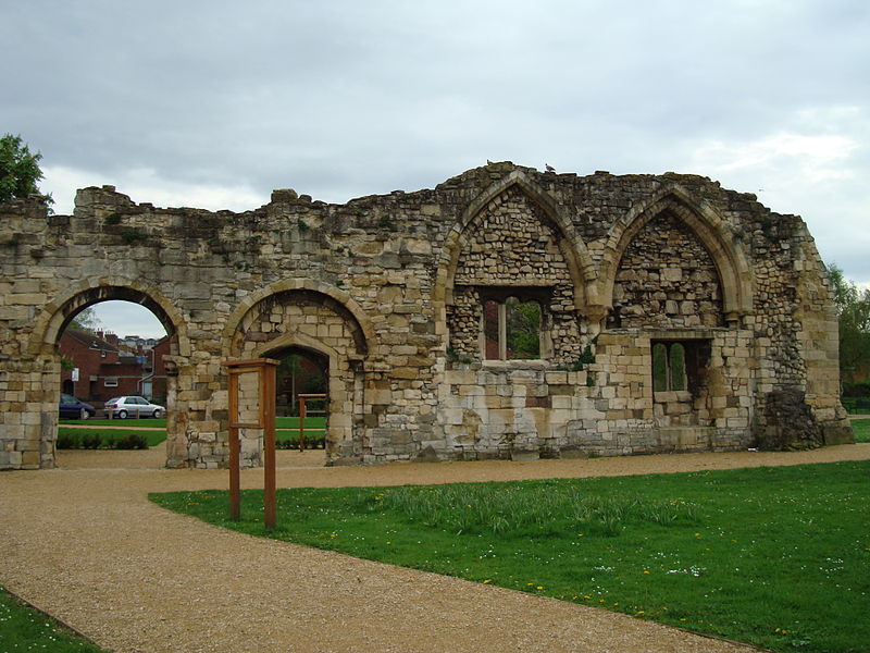
| Description | : | Founded in the late 880s or the 890s, by Ætherlfleda, daughter of Alfred the Great, and her husband Æthelred, ealdorman of Mercia. the priory soon declined into obscurity. Late in the reign of King Cnut, its estates were used as an endowment for a royal clerk. In 1089, Serlo, the Norman abbot of the original St Peter's Abbey, began an ambitious new church (later Gloucester Cathedral) to replace the old minster, and St. Oswald's, its emoluments much reduced, became a minor house of Augustinian canons. The monastery was suppressed in 1536, and became the parish church of St. Catherine, but... Read More |
frequently asked questions (FAQ):
-
Where is Saint Oswald's Priory?
Saint Oswald's Priory is located at Gloucester, City of Gloucester ,Gloucestershire ,England.
-
Saint Oswald's Priory cemetery's updated grave count on graveviews.com?
1 memorials
-
Where are the coordinates of the Saint Oswald's Priory?
Latitude: 51.8694000
Longitude: -2.2478000
Nearby Cemetories:
1. Gloucester Cathedral
Gloucester, City of Gloucester, England
Coordinate: 51.8675920, -2.2467670
2. St Nicholas' Church
Gloucester, City of Gloucester, England
Coordinate: 51.8672800, -2.2496760
3. St Margaret's Chapel
Gloucester, City of Gloucester, England
Coordinate: 51.8686720, -2.2321530
4. Llanthony Secunda Priory
Hempsted, City of Gloucester, England
Coordinate: 51.8602130, -2.2572640
5. Chapel of St Mary Magdalen
Gloucester, City of Gloucester, England
Coordinate: 51.8693000, -2.2291000
6. Saint Catharine's
Gloucester, City of Gloucester, England
Coordinate: 51.8691700, -2.2273500
7. Horton Road Cemetery
Gloucester, City of Gloucester, England
Coordinate: 51.8666900, -2.2268300
8. Gloucester Crematorium
Gloucester, City of Gloucester, England
Coordinate: 51.8538180, -2.2219260
9. St. Swithun's Churchyard
Hempsted, City of Gloucester, England
Coordinate: 51.8515740, -2.2719420
10. Gloucester Old Cemetery
Gloucester, City of Gloucester, England
Coordinate: 51.8482100, -2.2276700
11. St. Matthew's Cemetery
Twigworth, Tewkesbury Borough, England
Coordinate: 51.8936090, -2.2307820
12. St Lawrence Churchyard
Barnwood, City of Gloucester, England
Coordinate: 51.8580470, -2.2069750
13. St. Giles Churchyard
Maisemore, Tewkesbury Borough, England
Coordinate: 51.8931690, -2.2719540
14. Holy Innocents Churchyard
Highnam, Tewkesbury Borough, England
Coordinate: 51.8740890, -2.2970050
15. St. Oswald Churchyard
Lassington, Tewkesbury Borough, England
Coordinate: 51.8884700, -2.2978000
16. St Lawrence Churchyard
Sandhurst, Tewkesbury Borough, England
Coordinate: 51.9083260, -2.2489570
17. Ss Philip and James Churchyard
Hucclecote, Tewkesbury Borough, England
Coordinate: 51.8573040, -2.1876440
18. St Margaret Church
Whaddon, Stroud District, England
Coordinate: 51.8214600, -2.2433000
19. St. James' Churchyard
Quedgeley, City of Gloucester, England
Coordinate: 51.8257770, -2.2811150
20. St. Mary the Virgin Cemetery
Rudford, Forest of Dean District, England
Coordinate: 51.8936272, -2.3213976
21. St. Peter's Churchyard
Minsterworth, Tewkesbury Borough, England
Coordinate: 51.8511500, -2.3307800
22. St. Andrew's Churchyard
Churcham, Forest of Dean District, England
Coordinate: 51.8618970, -2.3375000
23. Hartpury Methodist Churchyard
Hartpury, Forest of Dean District, England
Coordinate: 51.9196444, -2.2883000
24. St George Churchyard
Brockworth, Tewkesbury Borough, England
Coordinate: 51.8517460, -2.1598180