
| Memorials | : | 0 |
| Location | : | Gloucester, City of Gloucester, England |
| Coordinate | : | 51.8666900, -2.2268300 |
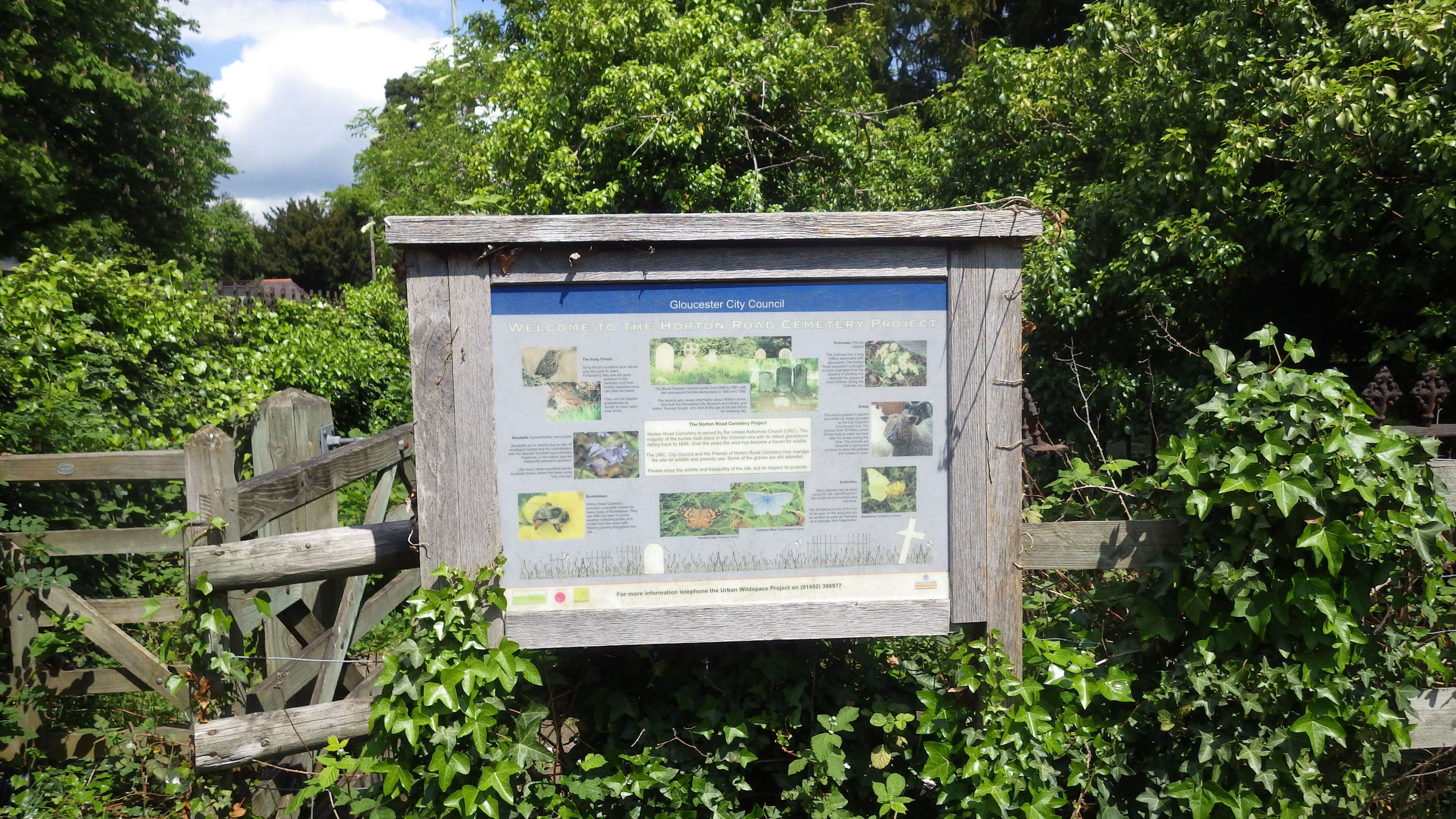
| Description | : | Also known as Wotton Cemetery, Horton Road. The small disused cemetery belongs to the United Reform Church. It is maintained as a wildlife haven, sheep are grazed there during autumn and winter helping to maintain the habitat. There are many mature trees on the site and often birdsong and wildflowers abound. Some graves are maintained however the wild nature of the cemetery means inscriptions are not easily seen. Burials took place from 1848, effectively ceasing in 1961 and the cemetery closed in 1992. Burial records can be accessed at the Gloucester Heritage Hub, Gloucester Archives, Alvin Street. |
frequently asked questions (FAQ):
-
Where is Horton Road Cemetery?
Horton Road Cemetery is located at Horton Road, Gloucester Gloucester, City of Gloucester ,Gloucestershire , GL1 3PYEngland.
-
Horton Road Cemetery cemetery's updated grave count on graveviews.com?
0 memorials
-
Where are the coordinates of the Horton Road Cemetery?
Latitude: 51.8666900
Longitude: -2.2268300
Nearby Cemetories:
1. Saint Catharine's
Gloucester, City of Gloucester, England
Coordinate: 51.8691700, -2.2273500
2. Chapel of St Mary Magdalen
Gloucester, City of Gloucester, England
Coordinate: 51.8693000, -2.2291000
3. St Margaret's Chapel
Gloucester, City of Gloucester, England
Coordinate: 51.8686720, -2.2321530
4. Gloucester Cathedral
Gloucester, City of Gloucester, England
Coordinate: 51.8675920, -2.2467670
5. Gloucester Crematorium
Gloucester, City of Gloucester, England
Coordinate: 51.8538180, -2.2219260
6. Saint Oswald's Priory
Gloucester, City of Gloucester, England
Coordinate: 51.8694000, -2.2478000
7. St Nicholas' Church
Gloucester, City of Gloucester, England
Coordinate: 51.8672800, -2.2496760
8. St Lawrence Churchyard
Barnwood, City of Gloucester, England
Coordinate: 51.8580470, -2.2069750
9. Gloucester Old Cemetery
Gloucester, City of Gloucester, England
Coordinate: 51.8482100, -2.2276700
10. Llanthony Secunda Priory
Hempsted, City of Gloucester, England
Coordinate: 51.8602130, -2.2572640
11. Ss Philip and James Churchyard
Hucclecote, Tewkesbury Borough, England
Coordinate: 51.8573040, -2.1876440
12. St. Matthew's Cemetery
Twigworth, Tewkesbury Borough, England
Coordinate: 51.8936090, -2.2307820
13. St. Swithun's Churchyard
Hempsted, City of Gloucester, England
Coordinate: 51.8515740, -2.2719420
14. St. Giles Churchyard
Maisemore, Tewkesbury Borough, England
Coordinate: 51.8931690, -2.2719540
15. St Lawrence Churchyard
Sandhurst, Tewkesbury Borough, England
Coordinate: 51.9083260, -2.2489570
16. Holy Innocents Churchyard
Highnam, Tewkesbury Borough, England
Coordinate: 51.8740890, -2.2970050
17. St George Churchyard
Brockworth, Tewkesbury Borough, England
Coordinate: 51.8517460, -2.1598180
18. St Margaret Church
Whaddon, Stroud District, England
Coordinate: 51.8214600, -2.2433000
19. St. Oswald Churchyard
Lassington, Tewkesbury Borough, England
Coordinate: 51.8884700, -2.2978000
20. Holy Trinity Churchyard
Badgeworth, Tewkesbury Borough, England
Coordinate: 51.8715360, -2.1444640
21. St. James' Churchyard
Quedgeley, City of Gloucester, England
Coordinate: 51.8257770, -2.2811150
22. Prinknash Abbey
Cranham, Stroud District, England
Coordinate: 51.8225000, -2.1761110
23. St. Swithun Churchyard
Brookthorpe, Stroud District, England
Coordinate: 51.8087500, -2.2402900
24. St. Mary the Virgin Cemetery
Rudford, Forest of Dean District, England
Coordinate: 51.8936272, -2.3213976