
| Memorials | : | 1 |
| Location | : | Zirconia, Henderson County, USA |
| Coordinate | : | 35.2424000, -82.4032000 |
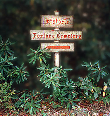
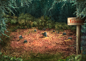
| Description | : | Located off Fortune Place Road in the Greenbriar Subdivision off U.S. 176 in the Zirconia community. Turn into the subdivision on Greenbriar Road. Turn left onto Hearthstone Lane, and then left onto Fortune Place Road. There is a sign pointing to the trail access area. There is an empty grassy area on the left where the trail is accessed. The trail is approximately 240 yards into the woods. This cemetery is the burial site of Revolutionary War soldier William Capps. The cemetery is located on the original property of William Capps. There are 46 field stones with... Read More |
frequently asked questions (FAQ):
-
Where is Fortune-Kuykendall Cemetery?
Fortune-Kuykendall Cemetery is located at Zirconia, Henderson County ,North Carolina ,USA.
-
Fortune-Kuykendall Cemetery cemetery's updated grave count on graveviews.com?
1 memorials
-
Where are the coordinates of the Fortune-Kuykendall Cemetery?
Latitude: 35.2424000
Longitude: -82.4032000
Nearby Cemetories:
1. Ward Family Cemetery
Henderson County, USA
Coordinate: 35.2308780, -82.4049850
2. Crossroads Baptist Church Cemetery
Zirconia, Henderson County, USA
Coordinate: 35.2287090, -82.4154320
3. Mountain View Baptist Church Cemetery
Tuxedo, Henderson County, USA
Coordinate: 35.2325000, -82.4285000
4. Anders Cemetery
East Flat Rock, Henderson County, USA
Coordinate: 35.2654700, -82.4064300
5. Tuxedo First Baptist Church Cemetery
Zirconia, Henderson County, USA
Coordinate: 35.2299000, -82.4285000
6. Oak Grove Baptist Church Cemetery
East Flat Rock, Henderson County, USA
Coordinate: 35.2729000, -82.4031580
7. Bell Family Cemetery
Tuxedo, Henderson County, USA
Coordinate: 35.2158970, -82.4247920
8. Grace Missionary Baptist Church Cemetery
Mountain Page, Henderson County, USA
Coordinate: 35.2176960, -82.3746780
9. Freeman-Murray Cemetery
Tuxedo, Henderson County, USA
Coordinate: 35.2185860, -82.4416270
10. Old Mountain Page Baptist Cemetery
Mountain Page, Henderson County, USA
Coordinate: 35.2190300, -82.3607200
11. Saluda City Cemetery
Saluda, Polk County, USA
Coordinate: 35.2438600, -82.3505400
12. Mountain Page Baptist Church Cemetery
Mountain Page, Henderson County, USA
Coordinate: 35.2097000, -82.3683400
13. Gilbert-Justus Family Cemetery
Upward, Henderson County, USA
Coordinate: 35.2861000, -82.3894380
14. Oakland Cemetery
East Flat Rock, Henderson County, USA
Coordinate: 35.2835999, -82.4302979
15. Hill Mausoleum
Flat Rock, Henderson County, USA
Coordinate: 35.2630638, -82.4577080
16. Pinecrest Presbyterian Church Memorial Garden
Flat Rock, Henderson County, USA
Coordinate: 35.2822100, -82.4426360
17. Andrews Cemetery
Henderson County, USA
Coordinate: 35.2089005, -82.4507980
18. Saint John In the Wilderness Cemetery
Flat Rock, Henderson County, USA
Coordinate: 35.2821170, -82.4435670
19. Davis Family Cemetery
Henderson County, USA
Coordinate: 35.1979750, -82.4363250
20. Pace Cemetery
Henderson County, USA
Coordinate: 35.2131004, -82.4625015
21. Mount Olivet Baptist Church Cemetery
Zirconia, Henderson County, USA
Coordinate: 35.2366900, -82.4749000
22. Jones Family Cemetery at Upward
Upward, Henderson County, USA
Coordinate: 35.3022003, -82.3855972
23. Double Springs Cemetery
Zirconia, Henderson County, USA
Coordinate: 35.1838989, -82.4289017
24. Beddingfield Cemetery
Henderson County, USA
Coordinate: 35.1948690, -82.4523670