
| Memorials | : | 0 |
| Location | : | Flat Rock, Henderson County, USA |
| Coordinate | : | 35.2630638, -82.4577080 |
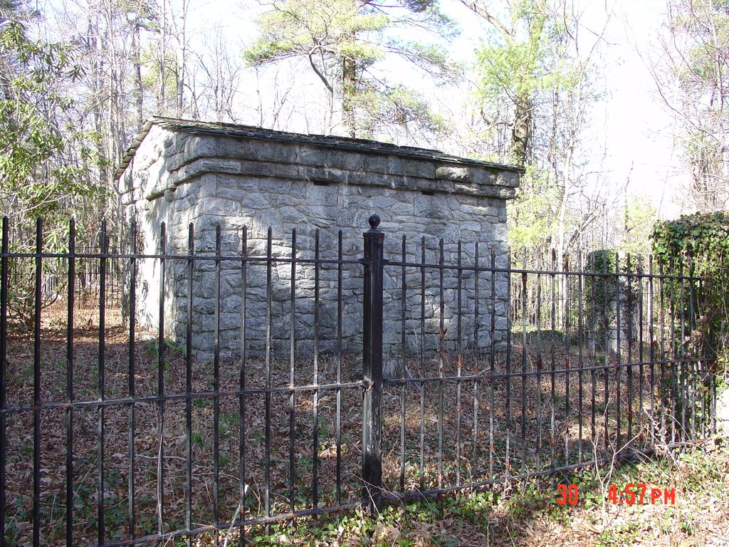
| Description | : | Located on top of Glassy Mountain in Flat Rock. There are two ways to get to the mausoleum. One is through the Kenmure Subdivision, a private gated community. The trail begins at Scenic Drive, 240 feet from Maple Hill Drive. The trail is about 470 feet to the top of Glassy Mountain. The general public cannot access the site by this route. The general public must use the Big Glassy Mountain Trail at the Carl Sandburg National Historic Site located on Little River Road in Flat Rock. The trail from the house to Big Glassy is 1.30... Read More |
frequently asked questions (FAQ):
-
Where is Hill Mausoleum?
Hill Mausoleum is located at Flat Rock, Henderson County ,North Carolina ,USA.
-
Hill Mausoleum cemetery's updated grave count on graveviews.com?
0 memorials
-
Where are the coordinates of the Hill Mausoleum?
Latitude: 35.2630638
Longitude: -82.4577080
Nearby Cemetories:
1. Saint John In the Wilderness Cemetery
Flat Rock, Henderson County, USA
Coordinate: 35.2821170, -82.4435670
2. Pinecrest Presbyterian Church Memorial Garden
Flat Rock, Henderson County, USA
Coordinate: 35.2822100, -82.4426360
3. Berea Baptist Church Cemetery
Flat Rock, Henderson County, USA
Coordinate: 35.2564011, -82.4875031
4. Mud Creek Baptist Church Cemetery
Flat Rock, Henderson County, USA
Coordinate: 35.2905998, -82.4536972
5. Mount Olivet Baptist Church Cemetery
Zirconia, Henderson County, USA
Coordinate: 35.2366900, -82.4749000
6. Oakland Cemetery
East Flat Rock, Henderson County, USA
Coordinate: 35.2835999, -82.4302979
7. Pleasant Hill Cemetery
Valley Hill, Henderson County, USA
Coordinate: 35.2750015, -82.4993973
8. Mountain View Baptist Church Cemetery
Tuxedo, Henderson County, USA
Coordinate: 35.2325000, -82.4285000
9. Tuxedo First Baptist Church Cemetery
Zirconia, Henderson County, USA
Coordinate: 35.2299000, -82.4285000
10. Anders Cemetery
East Flat Rock, Henderson County, USA
Coordinate: 35.2654700, -82.4064300
11. Oak Grove Baptist Church Cemetery
East Flat Rock, Henderson County, USA
Coordinate: 35.2729000, -82.4031580
12. Freeman-Murray Cemetery
Tuxedo, Henderson County, USA
Coordinate: 35.2185860, -82.4416270
13. Cantrell Family Cemetery
Henderson County, USA
Coordinate: 35.2869119, -82.5096819
14. Crossroads Baptist Church Cemetery
Zirconia, Henderson County, USA
Coordinate: 35.2287090, -82.4154320
15. Fortune-Kuykendall Cemetery
Zirconia, Henderson County, USA
Coordinate: 35.2424000, -82.4032000
16. Pace Cemetery
Henderson County, USA
Coordinate: 35.2131004, -82.4625015
17. Saint Francis Chapel Memorial Garden
Henderson County, USA
Coordinate: 35.2641670, -82.5200440
18. Harden Family Cemetery
Henderson County, USA
Coordinate: 35.2505100, -82.5191000
19. Ward Family Cemetery
Henderson County, USA
Coordinate: 35.2308780, -82.4049850
20. Bell Family Cemetery
Tuxedo, Henderson County, USA
Coordinate: 35.2158970, -82.4247920
21. Andrews Cemetery
Henderson County, USA
Coordinate: 35.2089005, -82.4507980
22. Adriance Family Cemetery
Henderson County, USA
Coordinate: 35.2511700, -82.5238300
23. First Congregational Church Memorial Garden
Hendersonville, Henderson County, USA
Coordinate: 35.3151530, -82.4841940
24. Mountain Valley Baptist Church Cemetery
Zirconia, Henderson County, USA
Coordinate: 35.2146988, -82.4938965