
| Memorials | : | 0 |
| Location | : | Upwaltham, Chichester District, England |
| Coordinate | : | 50.9164000, -0.6600810 |
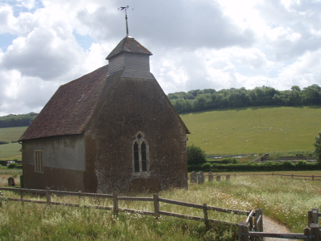
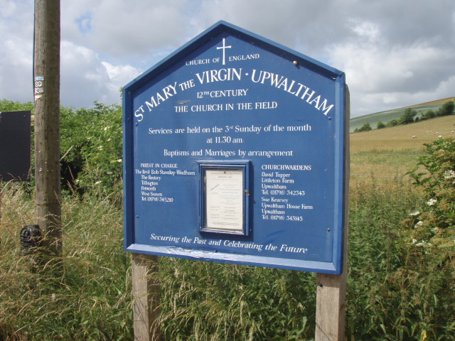
| Description | : | The early Norman church dedicated to St. Mary the Virgin is just over nine hundred years old, and remains little altered in size and structure, although the windows are not original, some being medieval and some Victorian. The three foot (90 cm) thick walls are of stone and downland flint. In Norman style the church has a tall narrow nave and a rounded apse chancel for the alter. The original round Norman chancel arch, between nave and chancel, was replaced after about 100 years by a wider pointed arch. The south door was rebuilt when the church was about 200... Read More |
frequently asked questions (FAQ):
-
Where is St Mary the Virgin?
St Mary the Virgin is located at Upwaltham, Chichester District ,West Sussex ,England.
-
St Mary the Virgin cemetery's updated grave count on graveviews.com?
0 memorials
-
Where are the coordinates of the St Mary the Virgin?
Latitude: 50.9164000
Longitude: -0.6600810

Nearby Cemetories:
1. St Peters Churchyard
East Lavington, Chichester District, England
Coordinate: 50.9379250, -0.6550920
2. All Saints Churchyard
East Dean, Chichester District, England
Coordinate: 50.9111110, -0.7136340
3. St. John The Baptist Churchyard Cemetery
Sutton, Chichester District, England
Coordinate: 50.9316638, -0.6080123
4. Holy Trinity Churchyard
Duncton, Chichester District, England
Coordinate: 50.9491400, -0.6337740
5. St Richard's Church
Duncton, Chichester District, England
Coordinate: 50.9486600, -0.6230000
6. St Richards Catholic Churchyard
Slindon, Arun District, England
Coordinate: 50.8680000, -0.6359000
7. St Mary Churchyard
Slindon, Arun District, England
Coordinate: 50.8666480, -0.6355800
8. St James Churchyard
Heyshott, Chichester District, England
Coordinate: 50.9556210, -0.7238880
9. St Mary and St Blaise Church
Boxgrove, Chichester District, England
Coordinate: 50.8599300, -0.7110320
10. St. John the Evangelist Churchyard
Bury, Chichester District, England
Coordinate: 50.9084756, -0.5565667
11. Goodwood House
Chichester, Chichester District, England
Coordinate: 50.8723110, -0.7394830
12. St Andrews Churchyard
West Dean, Chichester District, England
Coordinate: 50.9065650, -0.7762740
13. St Bartholomew Churchyard
Egdean, Chichester District, England
Coordinate: 50.9716740, -0.5819790
14. Pitshill Garden of Rest
Tillington, Chichester District, England
Coordinate: 50.9893710, -0.6320950
15. All Hallows Churchyard Extension
Tillington, Chichester District, England
Coordinate: 50.9893231, -0.6313783
16. All Hallows Churchyard
Tillington, Chichester District, England
Coordinate: 50.9893180, -0.6291640
17. St Mary Magdelene Churchyard
West Lavington, Chichester District, England
Coordinate: 50.9773640, -0.7311840
18. St Mary Churchyard
Aldingbourne, Arun District, England
Coordinate: 50.8436400, -0.6935500
19. West Dean Cemetery
West Dean, Chichester District, England
Coordinate: 50.9060300, -0.7796100
20. St Mary the Virgin Churchyard
Fittleworth, Chichester District, England
Coordinate: 50.9641190, -0.5641100
21. St Mary Churchyard
Walberton, Arun District, England
Coordinate: 50.8436840, -0.6186680
22. Bartons Lane Cemetery
Petworth, Chichester District, England
Coordinate: 50.9870920, -0.6073540
23. St Mary the Virgin Churchyard
Petworth, Chichester District, England
Coordinate: 50.9879345, -0.6096756
24. St Andrew Churchyard
Tangmere, Chichester District, England
Coordinate: 50.8479850, -0.7207170