
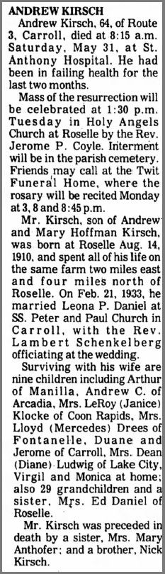
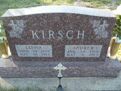
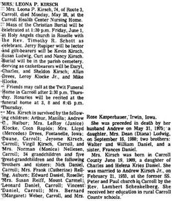
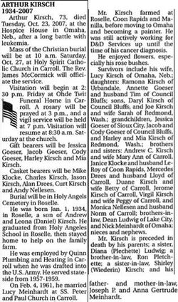
Andrew Kirsch
| Birth | : | 14 Aug 1910 Roselle, Carroll County, Iowa, USA |
| Death | : | 31 May 1975 Roselle, Carroll County, Iowa, USA |
| Burial | : | Forest Lawn Memorial Park, Erlanger, Kenton County, USA |
| Coordinate | : | 39.0163994, -84.5932999 |
| Description | : | Wife: Leona |
frequently asked questions (FAQ):
-
Where is Andrew Kirsch's memorial?
Andrew Kirsch's memorial is located at: Forest Lawn Memorial Park, Erlanger, Kenton County, USA.
-
When did Andrew Kirsch death?
Andrew Kirsch death on 31 May 1975 in Roselle, Carroll County, Iowa, USA
-
Where are the coordinates of the Andrew Kirsch's memorial?
Latitude: 39.0163994
Longitude: -84.5932999
Family Members:
Parent
Spouse
Siblings

Children
Flowers:


Nearby Cemetories:
1. Forest Lawn Memorial Park
Erlanger, Kenton County, USA
Coordinate: 39.0163994, -84.5932999
2. Stevenson Cemetery (Defunct)
Edgewood, Kenton County, USA
Coordinate: 39.0163320, -84.5980660
3. French Cemetery
Elsmere, Kenton County, USA
Coordinate: 39.0077780, -84.5944500
4. Casey Cemetery
Edgewood, Kenton County, USA
Coordinate: 39.0254170, -84.5865000
5. Dry Creek Baptist Church Cemetery
Edgewood, Kenton County, USA
Coordinate: 39.0183330, -84.5769440
6. Mary E. Smith Cemetery
Elsmere, Kenton County, USA
Coordinate: 39.0029060, -84.5938560
7. Yager Cemetery
Erlanger, Kenton County, USA
Coordinate: 39.0027780, -84.5933330
8. Beechwood Farm Cemetery
Crestview Hills, Kenton County, USA
Coordinate: 39.0304020, -84.5756360
9. Perry Family Burying Ground
Lakeside Park, Kenton County, USA
Coordinate: 39.0333600, -84.5724130
10. Wilhoit Cemetery
Florence, Boone County, USA
Coordinate: 38.9974070, -84.6187990
11. Ashbrook-Cheek Cemetery (Defunct)
Florence, Boone County, USA
Coordinate: 39.0116670, -84.6308350
12. Jarrell Cemetery
Erlanger, Kenton County, USA
Coordinate: 38.9901000, -84.5754870
13. Saint Pius X Seminary Cemetery
Florence, Boone County, USA
Coordinate: 39.0289460, -84.6280990
14. Clutterbuck Cemetery
Florence, Boone County, USA
Coordinate: 39.0041670, -84.6297230
15. Florence Cemetery
Florence, Boone County, USA
Coordinate: 39.0001000, -84.6309800
16. Passionist Monastery Cemetery
Erlanger, Kenton County, USA
Coordinate: 39.0350600, -84.6305300
17. Walton Cemetery
Hebron, Boone County, USA
Coordinate: 39.0456700, -84.6198900
18. Cain Cemetery
Edgewood, Kenton County, USA
Coordinate: 38.9905560, -84.5611110
19. Riggs Cemetery (Defunct)
Crescent Springs, Kenton County, USA
Coordinate: 39.0494440, -84.6138890
20. Carpenter Family Cemetery
Florence, Boone County, USA
Coordinate: 38.9914700, -84.6298610
21. Senour Cemetery
Edgewood, Kenton County, USA
Coordinate: 38.9905320, -84.5563500
22. Tupman Cemetery
Villa Hills, Kenton County, USA
Coordinate: 39.0528600, -84.6153440
23. Highland Pet Cemetery
Fort Mitchell, Kenton County, USA
Coordinate: 39.0384507, -84.5483047
24. Northern Kentucky Police K-9 Memorial
Fort Mitchell, Kenton County, USA
Coordinate: 39.0387149, -84.5476438