
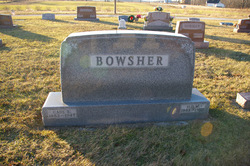
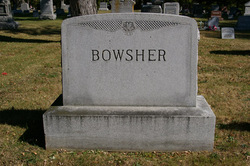
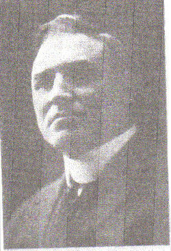
Carl Benjamin Bowsher
| Birth | : | 1 Mar 1885 Shawnee Township, Allen County, Ohio, USA |
| Death | : | 13 Nov 1947 Duchouquet Township, Auglaize County, Ohio, USA |
| Burial | : | St. Andrews Churchyard, Witham on the Hill, South Kesteven District, England |
| Coordinate | : | 52.7364500, -0.4420300 |
| Plot | : | Section J, Row 10 |
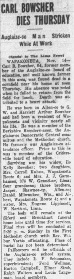
| Description | : | "Carl Bowsher, 64, was found dead at noon today in a cornfield on his farm, three miles north of Wapakoneta on Brewery Road. Death apparently resulted from a heart attack. His wife and two daughters survive." Nov 1947 |
frequently asked questions (FAQ):
-
Where is Carl Benjamin Bowsher's memorial?
Carl Benjamin Bowsher's memorial is located at: St. Andrews Churchyard, Witham on the Hill, South Kesteven District, England.
-
When did Carl Benjamin Bowsher death?
Carl Benjamin Bowsher death on 13 Nov 1947 in Duchouquet Township, Auglaize County, Ohio, USA
-
Where are the coordinates of the Carl Benjamin Bowsher's memorial?
Latitude: 52.7364500
Longitude: -0.4420300
Family Members:
Parent
Spouse

Siblings


Children
Flowers:


Nearby Cemetories:
1. St. Andrews Churchyard
Witham on the Hill, South Kesteven District, England
Coordinate: 52.7364500, -0.4420300
2. Saint Stephen
Carlby, South Kesteven District, England
Coordinate: 52.7125650, -0.4475800
3. St Stephen Churchyard
Careby, South Kesteven District, England
Coordinate: 52.7363500, -0.4823700
4. St Mary Magdalene Churchyard
Essendine, Rutland Unitary Authority, England
Coordinate: 52.7026000, -0.4489000
5. St Faith Churchyard
Wilsthorpe, South Kesteven District, England
Coordinate: 52.7095208, -0.3848166
6. St Wilfrid
Holywell, South Kesteven District, England
Coordinate: 52.7329915, -0.5149881
7. St Peter Churchyard
Creeton, South Kesteven District, England
Coordinate: 52.7669500, -0.4977300
8. St Firmin Churchyard
Thurlby, South Kesteven District, England
Coordinate: 52.7375960, -0.3646650
9. St Michael Churchyard
Edenham, South Kesteven District, England
Coordinate: 52.7836110, -0.4266560
10. Bourne Cemetery
Bourne, South Kesteven District, England
Coordinate: 52.7607264, -0.3714663
11. Bourne Abbey
Bourne, South Kesteven District, England
Coordinate: 52.7661320, -0.3758389
12. St John the Evangelist Churchyard
Ryhall, Rutland Unitary Authority, England
Coordinate: 52.6852000, -0.4685000
13. Ryhall Churchyard Extension
Ryhall, Rutland Unitary Authority, England
Coordinate: 52.6849000, -0.4678700
14. Baston Cemetery
Baston, South Kesteven District, England
Coordinate: 52.7149917, -0.3531338
15. St John the Baptist Churchyard
Baston, South Kesteven District, England
Coordinate: 52.7149530, -0.3530650
16. St James Churchyard
Castle Bytham, South Kesteven District, England
Coordinate: 52.7537140, -0.5367360
17. St Martin Churchyard
Barholm, South Kesteven District, England
Coordinate: 52.6855000, -0.3887600
18. St Mary Churchyard
Swinstead, South Kesteven District, England
Coordinate: 52.7900380, -0.4909380
19. All Saints Churchyard
Little Casterton, Rutland Unitary Authority, England
Coordinate: 52.6775807, -0.4965072
20. St Michael and All Angels Churchyard
Langtoft, South Kesteven District, England
Coordinate: 52.6990300, -0.3389800
21. St Nicholas Churchyard
Swayfield, South Kesteven District, England
Coordinate: 52.7922400, -0.5284400
22. St John the Baptist Churchyard
Morton, South Kesteven District, England
Coordinate: 52.8025100, -0.3724200
23. Newstead Priory
Stamford, South Kesteven District, England
Coordinate: 52.6582800, -0.4542480
24. St Michael & All Angels Churchyard
Uffington, South Kesteven District, England
Coordinate: 52.6570400, -0.4321700