
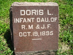
Doris L. Shipman
| Birth | : | 19 Oct 1895 |
| Death | : | 19 Oct 1895 |
| Burial | : | Bridgnorth Cemetery, Bridgnorth, Shropshire Unitary Authority, England |
| Coordinate | : | 52.5387350, -2.4078250 |
| Plot | : | Original Section 322 |
| Inscription | : | INFANT DAUGHTER OF R. M. & J. F. |
frequently asked questions (FAQ):
-
Where is Doris L. Shipman's memorial?
Doris L. Shipman's memorial is located at: Bridgnorth Cemetery, Bridgnorth, Shropshire Unitary Authority, England.
-
When did Doris L. Shipman death?
Doris L. Shipman death on 19 Oct 1895 in
-
Where are the coordinates of the Doris L. Shipman's memorial?
Latitude: 52.5387350
Longitude: -2.4078250
Family Members:
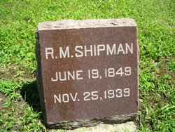
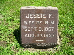
Parent
Siblings


Flowers:


Nearby Cemetories:
1. Bridgnorth Cemetery
Bridgnorth, Shropshire Unitary Authority, England
Coordinate: 52.5387350, -2.4078250
2. St Leonard Churchyard
Bridgnorth, Shropshire Unitary Authority, England
Coordinate: 52.5371970, -2.4187683
3. St Mary Magdelena Churchyard
Bridgnorth, Shropshire Unitary Authority, England
Coordinate: 52.5325220, -2.4187470
4. St. Calixtus Churchyard
Astley Abbotts, Shropshire Unitary Authority, England
Coordinate: 52.5631160, -2.4312720
5. St Bartholomew Churchyard
Glazeley, Shropshire Unitary Authority, England
Coordinate: 52.4913000, -2.4385000
6. Saint Peter's Church
Chelmarsh, Shropshire Unitary Authority, England
Coordinate: 52.4878300, -2.4129890
7. St. Giles Churchyard
Chetton, Shropshire Unitary Authority, England
Coordinate: 52.5101600, -2.4966300
8. All Saints Churchyard
Claverley, Shropshire Unitary Authority, England
Coordinate: 52.5382800, -2.3069010
9. St. Giles Churchyard
Badger, Shropshire Unitary Authority, England
Coordinate: 52.5936507, -2.3438993
10. St Milburga's Churchyard
Beckbury, Shropshire Unitary Authority, England
Coordinate: 52.6113140, -2.3481180
11. All Saints Churchyard
Broseley, Shropshire Unitary Authority, England
Coordinate: 52.6105890, -2.4757160
12. St. Mary's Churchyard
Acton Round, Shropshire Unitary Authority, England
Coordinate: 52.5573080, -2.5406470
13. St. Giles Church Cemetery
Barrow, Shropshire Unitary Authority, England
Coordinate: 52.5969300, -2.5065700
14. Holy Innocents Churchyard
Alveley, Shropshire Unitary Authority, England
Coordinate: 52.4932817, -2.2902335
15. Saint Mary the Virgin Churchyard
Alveley, Shropshire Unitary Authority, England
Coordinate: 52.4581590, -2.3553520
16. Broseley Baptist Church
Broseley, Shropshire Unitary Authority, England
Coordinate: 52.6135650, -2.4871190
17. The Red Church
Broseley, Shropshire Unitary Authority, England
Coordinate: 52.6205367, -2.4753955
18. St. Mary's Churchyard
Highley, Shropshire Unitary Authority, England
Coordinate: 52.4465100, -2.3818640
19. Chorley Chapel Burial Ground
Chorley, Shropshire Unitary Authority, England
Coordinate: 52.4463570, -2.4409710
20. St Mary Patshull Burnhill Green
Pattingham, South Staffordshire Borough, England
Coordinate: 52.6056540, -2.2916790
21. St. Michael's Churchyard
Madeley, Telford and Wrekin Unitary Authority, England
Coordinate: 52.6337300, -2.4503010
22. St Chad Churchyard
Pattingham, South Staffordshire Borough, England
Coordinate: 52.5897150, -2.2656570
23. St. Bartholomew Churchyard
Benthall, Shropshire Unitary Authority, England
Coordinate: 52.6198230, -2.5068570
24. St. Luke's Churchyard
Ironbridge, Telford and Wrekin Unitary Authority, England
Coordinate: 52.6285830, -2.4851180