
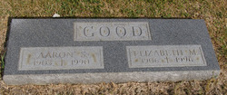
| Birth | : | 16 Aug 1927 Cloverdale, Putnam County, Ohio, USA |
| Death | : | 27 Mar 2003 Toledo, Lucas County, Ohio, USA |
| Burial | : | Pettisville Cemetery, Pettisville, Fulton County, USA |
| Coordinate | : | 41.5302620, -84.2258690 |
| Description | : | ARCHBOLD - Dorthea J. Sauder, 75, of Archbold, died Thursday morning, March 27, 2003, at the Toledo Hospital, where she had been a patient since Feb. 16. Born Aug. 16, 1927, at Cloverdale, to Elizabeth (Good) and Aaron Good, she married Loren Sauder on Oct. 28, 1949, and he survives. A resident of the Archbold area for the past 53 years, she was a homemaker and a member of the Central Mennonite Church near Archbold. In addition to her husband, she is survived by two sons, Steven (and wife, Rachel) Sauder and Nathan Sauder, both of Archbold; a daughter, Mrs.... Read More |
frequently asked questions (FAQ):
-
Where is Dorthea Jean Good Sauder's memorial?
Dorthea Jean Good Sauder's memorial is located at: Pettisville Cemetery, Pettisville, Fulton County, USA.
-
When did Dorthea Jean Good Sauder death?
Dorthea Jean Good Sauder death on 27 Mar 2003 in Toledo, Lucas County, Ohio, USA
-
Where are the coordinates of the Dorthea Jean Good Sauder's memorial?
Latitude: 41.5302620
Longitude: -84.2258690
Family Members:
Parent

Spouse

Siblings
Flowers:


Nearby Cemetories:
1. Pettisville Cemetery
Pettisville, Fulton County, USA
Coordinate: 41.5302620, -84.2258690
2. Pettisville Union Cemetery
Pettisville, Fulton County, USA
Coordinate: 41.5294190, -84.2258910
3. Pettisville Lutheran Cemetery
Pettisville, Fulton County, USA
Coordinate: 41.5321900, -84.2237400
4. Aeschliman Cemetery
Pettisville, Fulton County, USA
Coordinate: 41.5147018, -84.2192001
5. Saint James Lutheran Cemetery
Burlington, Fulton County, USA
Coordinate: 41.5428009, -84.2630997
6. Eckley Cemetery
Eckley, Fulton County, USA
Coordinate: 41.5641600, -84.2491200
7. Lena Cemetery
Fulton County, USA
Coordinate: 41.5175018, -84.1731033
8. Rupp Cemetery
Archbold, Fulton County, USA
Coordinate: 41.5140110, -84.2771370
9. North Pettisville Cemetery
Wauseon, Fulton County, USA
Coordinate: 41.5728190, -84.2200180
10. Beck Cemetery
Fulton County, USA
Coordinate: 41.5648620, -84.2682880
11. Wyse Cemetery
Fulton County, USA
Coordinate: 41.5647820, -84.2686700
12. Saint Peters Cemetery
Archbold, Fulton County, USA
Coordinate: 41.5428009, -84.2882996
13. Bayes Cemetery
Wauseon, Fulton County, USA
Coordinate: 41.5581017, -84.1706009
14. Mikesell Cemetery
Wauseon, Fulton County, USA
Coordinate: 41.5511017, -84.1631012
15. Lauber Hill Cemetery
Fulton County, USA
Coordinate: 41.5742410, -84.2681490
16. Wauseon Union Cemetery
Wauseon, Fulton County, USA
Coordinate: 41.5480995, -84.1564026
17. Saint Caspar Catholic Cemetery
Wauseon, Fulton County, USA
Coordinate: 41.5479500, -84.1557600
18. Freedom Township Cemetery
Freedom Township, Henry County, USA
Coordinate: 41.4752970, -84.2069960
19. Reform Cemetery
Archbold, Fulton County, USA
Coordinate: 41.5039790, -84.3061070
20. Smith Cemetery
Franklin Township, Fulton County, USA
Coordinate: 41.5957985, -84.2316971
21. Archbold Cemetery
Archbold, Fulton County, USA
Coordinate: 41.5028000, -84.3058014
22. Ayers Cemetery
Fulton County, USA
Coordinate: 41.5960999, -84.2296982
23. Tedrow Cemetery
Tedrow, Fulton County, USA
Coordinate: 41.6019300, -84.1975100
24. Saint Lukes Lutheran Church Cemetery
Fulton County, USA
Coordinate: 41.4963100, -84.1340700