
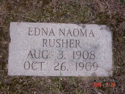
Edna Naoma Rusher
| Birth | : | 3 Aug 1908 USA |
| Death | : | 26 Oct 1909 USA |
| Burial | : | St. Michael & All Angels Churchyard, Penkridge, South Staffordshire Borough, England |
| Coordinate | : | 52.7245874, -2.1181258 |
frequently asked questions (FAQ):
-
Where is Edna Naoma Rusher's memorial?
Edna Naoma Rusher's memorial is located at: St. Michael & All Angels Churchyard, Penkridge, South Staffordshire Borough, England.
-
When did Edna Naoma Rusher death?
Edna Naoma Rusher death on 26 Oct 1909 in USA
-
Where are the coordinates of the Edna Naoma Rusher's memorial?
Latitude: 52.7245874
Longitude: -2.1181258
Family Members:
Parent

Siblings
Flowers:


Nearby Cemetories:
1. Christ Church
Gailey, South Staffordshire Borough, England
Coordinate: 52.6933900, -2.1308200
2. St. James Churchyard
Acton Trussell, South Staffordshire Borough, England
Coordinate: 52.7546980, -2.0943120
3. Saint John's Churchyard
Stretton, South Staffordshire Borough, England
Coordinate: 52.6999790, -2.1720920
4. All Saints Churchyard
Lapley, South Staffordshire Borough, England
Coordinate: 52.7138900, -2.1902330
5. St. Saviour Churchyard
Hatherton, South Staffordshire Borough, England
Coordinate: 52.6841730, -2.0660840
6. St Mary and All Saints
Bradley, Stafford Borough, England
Coordinate: 52.7599257, -2.1808769
7. Cannock Chase War Cemetery
Cannock, Cannock Chase District, England
Coordinate: 52.7370710, -2.0266340
8. Cannock Chase German Military Cemetery
Cannock, Cannock Chase District, England
Coordinate: 52.7370580, -2.0265050
9. Cannock Cemetery
Cannock, Cannock Chase District, England
Coordinate: 52.7008790, -2.0288950
10. St Mary and St Chad Churchyard
Brewood, South Staffordshire Borough, England
Coordinate: 52.6754850, -2.1738520
11. St. Luke's Churchyard
Cannock, Cannock Chase District, England
Coordinate: 52.6889919, -2.0287352
12. St Mary Roman Catholic Churchyard
Cannock, Cannock Chase District, England
Coordinate: 52.6867620, -2.0283360
13. St. Editha's Parish Church Graveyard
Church Eaton, Stafford Borough, England
Coordinate: 52.7560690, -2.2259540
14. St Giles Churchyard
Haughton, Stafford Borough, England
Coordinate: 52.7817750, -2.2005140
15. Our Lady of Lourdes Churchyard
Hednesford, Cannock Chase District, England
Coordinate: 52.7051311, -1.9969935
16. St. Peter's Churchyard
Hednesford, Cannock Chase District, England
Coordinate: 52.7050630, -1.9918330
17. Cheslyn Hay Cemetery
Cheslyn Hay, South Staffordshire Borough, England
Coordinate: 52.6581170, -2.0431790
18. St. Mary's Churchyard
Stafford, Stafford Borough, England
Coordinate: 52.8057000, -2.1187000
19. St Chad
Stafford, Stafford Borough, England
Coordinate: 52.8061611, -2.1165797
20. St. Mark's Churchyard
Great Wyrley, South Staffordshire Borough, England
Coordinate: 52.6664250, -2.0231955
21. Great Wyrley Cemetery
Great Wyrley, South Staffordshire Borough, England
Coordinate: 52.6642130, -2.0269380
22. Saint Johns Church
Bishops Wood, Shropshire Unitary Authority, England
Coordinate: 52.6810030, -2.2369880
23. St John Churchyard
Heath Hayes, Cannock Chase District, England
Coordinate: 52.6914160, -1.9846280
24. Stafford Crematorium and Burial Ground
Stafford, Stafford Borough, England
Coordinate: 52.8080900, -2.0747420