

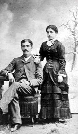
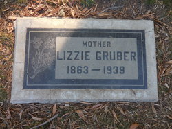
Elizabeth Catherine “Lizzie” Tuley Gruber
| Birth | : | 4 Aug 1863 Lewis County, Missouri, USA |
| Death | : | 23 Feb 1939 Fullerton, Orange County, California, USA |
| Burial | : | Folsom Prison Cemetery, Folsom, Sacramento County, USA |
| Coordinate | : | 38.6952860, -121.1636690 |
| Plot | : | Evergreen Lawn |
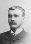
| Description | : | Relatives received word Friday morning that Mrs. John Gruber of Fullerton, Calif., died suddenly Thursday evening at her home. She was the daughter of William Addison and Rebecca Ann Tuley, was raised in Lewis county. She lived near LaGrange until about ten years old and moved near Benjamin where she lived until united in marriage to John Gruber December 25, 1890, and left Missouri the fall of 1918 for the sunny clime in which she died. She had been in failing health for some time but her death was not expected although she had been in four... Read More |
frequently asked questions (FAQ):
-
Where is Elizabeth Catherine “Lizzie” Tuley Gruber's memorial?
Elizabeth Catherine “Lizzie” Tuley Gruber's memorial is located at: Folsom Prison Cemetery, Folsom, Sacramento County, USA.
-
When did Elizabeth Catherine “Lizzie” Tuley Gruber death?
Elizabeth Catherine “Lizzie” Tuley Gruber death on 23 Feb 1939 in Fullerton, Orange County, California, USA
-
Where are the coordinates of the Elizabeth Catherine “Lizzie” Tuley Gruber's memorial?
Latitude: 38.6952860
Longitude: -121.1636690
Family Members:
Flowers:


Nearby Cemetories:
1. Folsom Prison Cemetery
Folsom, Sacramento County, USA
Coordinate: 38.6952860, -121.1636690
2. Saint John the Baptist Catholic Church Cemetery
Folsom, Sacramento County, USA
Coordinate: 38.6721900, -121.1803000
3. F.O.E. 929 Cemetery
Folsom, Sacramento County, USA
Coordinate: 38.6717010, -121.1801010
4. Young Wo Cemetery
Folsom, Sacramento County, USA
Coordinate: 38.6733400, -121.1835000
5. Lakeside Memorial Lawn Cemetery
Folsom, Sacramento County, USA
Coordinate: 38.6715300, -121.1841000
6. China Mission-Chung Wah Chinese Cemetery
Folsom, Sacramento County, USA
Coordinate: 38.6698410, -121.1851790
7. Mormon Island Relocation Cemetery
El Dorado Hills, El Dorado County, USA
Coordinate: 38.6986084, -121.1093521
8. Mount Vernon Memorial Park
Fair Oaks, Sacramento County, USA
Coordinate: 38.6800003, -121.2566986
9. Clarksville Cemetery
Clarksville, El Dorado County, USA
Coordinate: 38.6546707, -121.0615387
10. Railroad House Cemetery
Clarksville, El Dorado County, USA
Coordinate: 38.6575699, -121.0516129
11. Shepherd of the Sierra Memorial Garden
Loomis, Placer County, USA
Coordinate: 38.7890800, -121.1944200
12. Sylvan Cemetery
Citrus Heights, Sacramento County, USA
Coordinate: 38.7001534, -121.2904587
13. Fair Oaks Cemetery
Fair Oaks, Sacramento County, USA
Coordinate: 38.6501167, -121.2792000
14. Fair Oaks United Methodist Church Memorial Garden
Fair Oaks, Sacramento County, USA
Coordinate: 38.6396300, -121.2744600
15. Rocklin Cemetery
Rocklin, Placer County, USA
Coordinate: 38.7827670, -121.2337980
16. Boothill Cemetery
Roseville, Placer County, USA
Coordinate: 38.7598730, -121.2712130
17. Roseville Public Cemetery District
Roseville, Placer County, USA
Coordinate: 38.7606010, -121.2707977
18. Morrison Ranch Family Cemetery
Clarksville, El Dorado County, USA
Coordinate: 38.6552887, -121.0368500
19. Rust Family Gravesite
Cameron Park, El Dorado County, USA
Coordinate: 38.6980160, -121.0207130
20. Prosser Family Cemetery
Loomis, Placer County, USA
Coordinate: 38.8071900, -121.1285600
21. Green Valley Cemetery
Rescue, El Dorado County, USA
Coordinate: 38.6993790, -121.0081406
22. Mansur Family Cemetery
Loomis, Placer County, USA
Coordinate: 38.8139600, -121.1214000
23. Calvary Catholic Cemetery and Mausoleum
Sacramento, Sacramento County, USA
Coordinate: 38.6937180, -121.3233109
24. Kilgore Cemetery
Rancho Cordova, Sacramento County, USA
Coordinate: 38.5978012, -121.2683029