
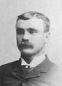
John Gruber
| Birth | : | 25 Aug 1863 Lewis County, Missouri, USA |
| Death | : | 3 Feb 1935 Fullerton, Orange County, California, USA |
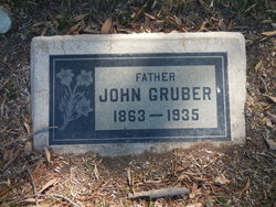
| Burial | : | Folsom Prison Cemetery, Folsom, Sacramento County, USA |
| Coordinate | : | 38.6952860, -121.1636690 |
| Plot | : | Evergreen Lawn |
| Description | : | Funeral services were held yesterday afternoon, for John Gruber, 71, known to everyone in Fullerton as "Popcorn John", who was fatally injured about 9 p. m. Saturday when he was struck while pushing his wagon to his home by a car driven by Charlie DeBoer of Buena Park. The accident occurred on the corner of Jacaranda Pl. and Highland Ave. According to a report turned in by DeBoer, Gruber was struck as the car apparently backed into the wagon as DeBoer was leaving a parking place on Jacaranda pl. Gruber was taken to the Fullerton General hospital... Read More |
frequently asked questions (FAQ):
-
Where is John Gruber's memorial?
John Gruber's memorial is located at: Folsom Prison Cemetery, Folsom, Sacramento County, USA.
-
When did John Gruber death?
John Gruber death on 3 Feb 1935 in Fullerton, Orange County, California, USA
-
Where are the coordinates of the John Gruber's memorial?
Latitude: 38.6952860
Longitude: -121.1636690
Family Members:
Parent
Spouse

Siblings

Children
Flowers:


Nearby Cemetories:
1. Folsom Prison Cemetery
Folsom, Sacramento County, USA
Coordinate: 38.6952860, -121.1636690
2. Saint John the Baptist Catholic Church Cemetery
Folsom, Sacramento County, USA
Coordinate: 38.6721900, -121.1803000
3. F.O.E. 929 Cemetery
Folsom, Sacramento County, USA
Coordinate: 38.6717010, -121.1801010
4. Young Wo Cemetery
Folsom, Sacramento County, USA
Coordinate: 38.6733400, -121.1835000
5. Lakeside Memorial Lawn Cemetery
Folsom, Sacramento County, USA
Coordinate: 38.6715300, -121.1841000
6. China Mission-Chung Wah Chinese Cemetery
Folsom, Sacramento County, USA
Coordinate: 38.6698410, -121.1851790
7. Mormon Island Relocation Cemetery
El Dorado Hills, El Dorado County, USA
Coordinate: 38.6986084, -121.1093521
8. Mount Vernon Memorial Park
Fair Oaks, Sacramento County, USA
Coordinate: 38.6800003, -121.2566986
9. Clarksville Cemetery
Clarksville, El Dorado County, USA
Coordinate: 38.6546707, -121.0615387
10. Railroad House Cemetery
Clarksville, El Dorado County, USA
Coordinate: 38.6575699, -121.0516129
11. Shepherd of the Sierra Memorial Garden
Loomis, Placer County, USA
Coordinate: 38.7890800, -121.1944200
12. Sylvan Cemetery
Citrus Heights, Sacramento County, USA
Coordinate: 38.7001534, -121.2904587
13. Fair Oaks Cemetery
Fair Oaks, Sacramento County, USA
Coordinate: 38.6501167, -121.2792000
14. Fair Oaks United Methodist Church Memorial Garden
Fair Oaks, Sacramento County, USA
Coordinate: 38.6396300, -121.2744600
15. Rocklin Cemetery
Rocklin, Placer County, USA
Coordinate: 38.7827670, -121.2337980
16. Boothill Cemetery
Roseville, Placer County, USA
Coordinate: 38.7598730, -121.2712130
17. Roseville Public Cemetery District
Roseville, Placer County, USA
Coordinate: 38.7606010, -121.2707977
18. Morrison Ranch Family Cemetery
Clarksville, El Dorado County, USA
Coordinate: 38.6552887, -121.0368500
19. Rust Family Gravesite
Cameron Park, El Dorado County, USA
Coordinate: 38.6980160, -121.0207130
20. Prosser Family Cemetery
Loomis, Placer County, USA
Coordinate: 38.8071900, -121.1285600
21. Green Valley Cemetery
Rescue, El Dorado County, USA
Coordinate: 38.6993790, -121.0081406
22. Mansur Family Cemetery
Loomis, Placer County, USA
Coordinate: 38.8139600, -121.1214000
23. Calvary Catholic Cemetery and Mausoleum
Sacramento, Sacramento County, USA
Coordinate: 38.6937180, -121.3233109
24. Kilgore Cemetery
Rancho Cordova, Sacramento County, USA
Coordinate: 38.5978012, -121.2683029